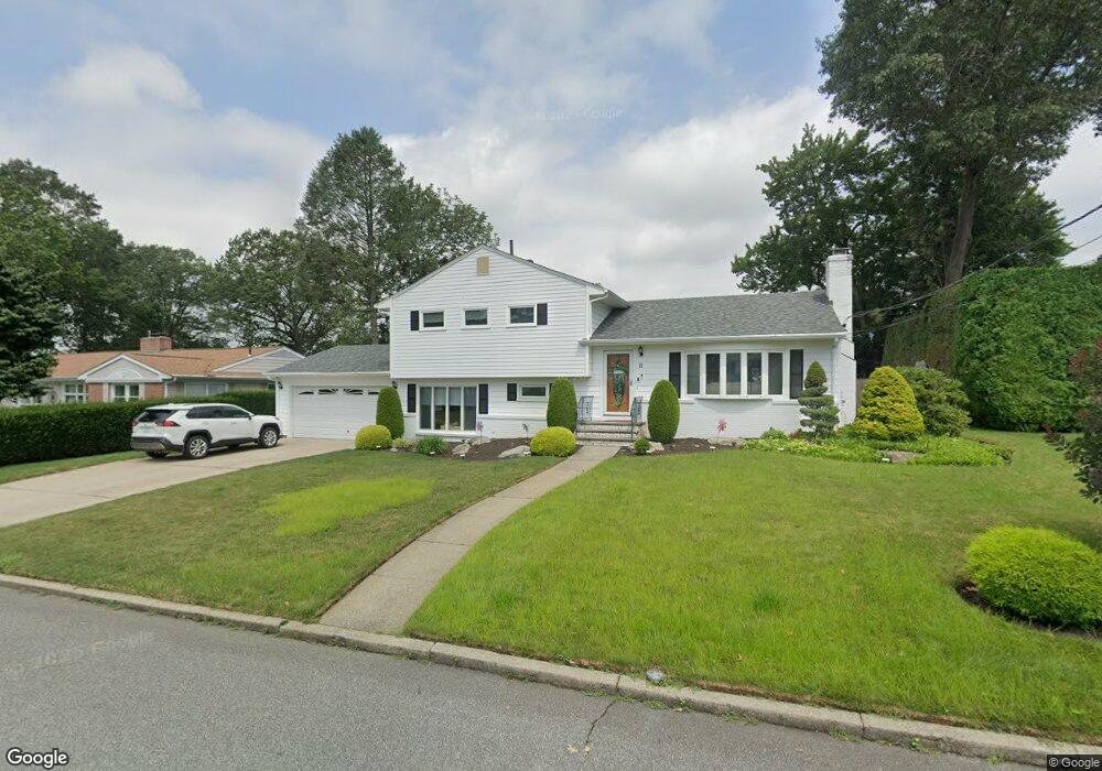
11 W Bel Air Rd Cranston, RI 02920
Meshanticut NeighborhoodEstimated Value: $489,702 - $601,000
3
Beds
2
Baths
2,152
Sq Ft
$254/Sq Ft
Est. Value
About This Home
This home is located at 11 W Bel Air Rd, Cranston, RI 02920 and is currently estimated at $546,426, approximately $253 per square foot. 11 W Bel Air Rd is a home located in Providence County with nearby schools including Glen Hills School, Western Hills Middle School, and Cranston High School West.
Ownership History
Date
Name
Owned For
Owner Type
Purchase Details
Closed on
Jul 8, 1999
Sold by
Perelman Todd M and Perelman Lisa
Bought by
Grover William A and Grover Sandra
Current Estimated Value
Home Financials for this Owner
Home Financials are based on the most recent Mortgage that was taken out on this home.
Original Mortgage
$30,000
Outstanding Balance
$8,003
Interest Rate
7.19%
Estimated Equity
$538,423
Create a Home Valuation Report for This Property
The Home Valuation Report is an in-depth analysis detailing your home's value as well as a comparison with similar homes in the area
Home Values in the Area
Average Home Value in this Area
Purchase History
| Date | Buyer | Sale Price | Title Company |
|---|---|---|---|
| Grover William A | $190,000 | -- |
Source: Public Records
Mortgage History
| Date | Status | Borrower | Loan Amount |
|---|---|---|---|
| Open | Grover William A | $30,000 |
Source: Public Records
Tax History Compared to Growth
Tax History
| Year | Tax Paid | Tax Assessment Tax Assessment Total Assessment is a certain percentage of the fair market value that is determined by local assessors to be the total taxable value of land and additions on the property. | Land | Improvement |
|---|---|---|---|---|
| 2025 | $6,456 | $465,100 | $140,800 | $324,300 |
| 2024 | $6,330 | $465,100 | $140,800 | $324,300 |
| 2023 | $6,231 | $329,700 | $100,700 | $229,000 |
| 2022 | $6,103 | $329,700 | $100,700 | $229,000 |
| 2021 | $5,935 | $329,700 | $100,700 | $229,000 |
| 2020 | $5,986 | $288,200 | $104,300 | $183,900 |
| 2019 | $5,986 | $288,200 | $104,300 | $183,900 |
| 2018 | $5,848 | $288,200 | $104,300 | $183,900 |
| 2017 | $5,717 | $249,200 | $97,100 | $152,100 |
| 2016 | $5,595 | $249,200 | $97,100 | $152,100 |
| 2015 | $5,595 | $249,200 | $97,100 | $152,100 |
| 2014 | $5,774 | $252,800 | $104,300 | $148,500 |
Source: Public Records
Map
Nearby Homes
- 189 Summit Dr
- 45 Hamden Rd
- 145 E Hill Dr
- 51 E Bel Air Rd
- 7 Oak Tree Ln
- 275 Meshanticut Valley Pkwy
- 203 Dean Ridge Ct
- 200 Hoffman Ave Unit 505
- 132 Hoffman Ave Unit 115
- 132 Hoffman Ave Unit 207
- 132 Hoffman Ave Unit 110
- 143 Hoffman Ave Unit 109
- 143 Hoffman Ave Unit 110
- 143 Hoffman Ave Unit 206
- 46 Lilyana Way
- 29 Valley St
- 141 Glen Ridge Rd
- 0 Wain St
- 269 Glen Hills Dr
- 189 Poplar Dr
- 19 W Bel Air Rd
- 21 W Hamden Rd
- 20 W Blue Ridge Rd
- 9 W Blue Ridge Rd
- 14 W Bel Air Rd
- 22 W Blue Ridge Rd
- 20 W Bel Air Rd
- 6 W Bel Air Rd
- 23 W Bel Air Rd
- 28 W Bel Air Rd
- 32 W Hamden Rd
- 101 Park Forest Rd
- 11 W Blue Ridge Rd
- 30 W Blue Ridge Rd
- 51 W Hamden Rd
- 33 W Bel Air Rd
- 109 Park Forest Rd
- 93 Park Forest Rd
- 22 W Hamden Rd
- 46 W Hamden Rd