Estimated Value: $3,007,000 - $3,846,000
4
Beds
5
Baths
3,515
Sq Ft
$1,013/Sq Ft
Est. Value
About This Home
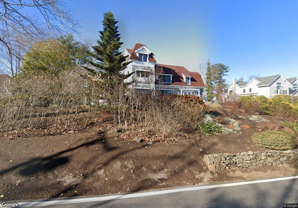
This home is located at 11 Wentworth Rd, Rye, NH 03870 and is currently estimated at $3,560,762, approximately $1,013 per square foot. 11 Wentworth Rd is a home located in Rockingham County with nearby schools including Rye Elementary School, Rye Junior High School, and St Patrick School.
Ownership History
Date
Name
Owned For
Owner Type
Purchase Details
Closed on
Aug 24, 2012
Sold by
Devore Robert W
Bought by
Robert W Devore Ret and Devore
Current Estimated Value
Purchase Details
Closed on
Sep 13, 2002
Sold by
Hansen Paul
Bought by
Devore Robert W
Home Financials for this Owner
Home Financials are based on the most recent Mortgage that was taken out on this home.
Original Mortgage
$600,000
Interest Rate
6.48%
Mortgage Type
Purchase Money Mortgage
Create a Home Valuation Report for This Property
The Home Valuation Report is an in-depth analysis detailing your home's value as well as a comparison with similar homes in the area
Home Values in the Area
Average Home Value in this Area
Purchase History
| Date | Buyer | Sale Price | Title Company |
|---|---|---|---|
| Robert W Devore Ret | -- | -- | |
| Devore Robert W | $1,300,000 | -- |
Source: Public Records
Mortgage History
| Date | Status | Borrower | Loan Amount |
|---|---|---|---|
| Previous Owner | Devore Robert W | $267,500 | |
| Previous Owner | Devore Robert W | $383,000 | |
| Previous Owner | Devore Robert W | $600,000 |
Source: Public Records
Tax History Compared to Growth
Tax History
| Year | Tax Paid | Tax Assessment Tax Assessment Total Assessment is a certain percentage of the fair market value that is determined by local assessors to be the total taxable value of land and additions on the property. | Land | Improvement |
|---|---|---|---|---|
| 2024 | $19,669 | $2,271,200 | $1,490,400 | $780,800 |
| 2023 | $18,238 | $2,271,200 | $1,490,400 | $780,800 |
| 2022 | $15,853 | $2,271,200 | $1,490,400 | $780,800 |
| 2021 | $19,351 | $1,893,400 | $1,063,800 | $829,600 |
| 2020 | $20,373 | $1,893,400 | $1,063,800 | $829,600 |
| 2019 | $19,351 | $1,893,400 | $1,063,800 | $829,600 |
| 2018 | $19,233 | $1,829,200 | $1,063,800 | $765,400 |
| 2017 | $18,493 | $1,829,200 | $1,063,800 | $765,400 |
| 2016 | $18,497 | $1,731,900 | $966,700 | $765,200 |
| 2013 | $17,514 | $1,596,500 | $966,700 | $629,800 |
Source: Public Records
Map
Nearby Homes
- 163 Little Harbor Rd
- 167 Little Harbor Rd
- 112 Wentworth Rd
- 57 Old Bay Rd
- 18 Mainmast Cir
- 267 Pioneer Rd
- 1 Sagamore Grove
- 137 Walker Bungalow Rd
- 1155 Sagamore Ave Unit 2
- 1155 Sagamore Ave Unit 3
- 1155 Sagamore Ave Unit D
- 1155 Sagamore Ave Unit 1
- 4 Sagamore Rd
- 175 Wentworth Rd
- 14 Colonial Ln
- 14 Sagamore Rd Unit 3
- 17 Elm Ct
- 15 Atkinson St
- 24 Seabreeze Ln
- 149 Jones Ave
- 21 Wentworth Rd
- 5 Wentworth Rd
- 3 Wentworth Rd
- 23 Wentworth Rd
- 16 Wentworth Rd
- 27 Wentworth Rd
- 27 Wentworth Rd Unit 1
- 27 Wentworth St Unit 1
- 2 Wentworth Rd
- 33 Wentworth Rd
- 35 Wentworth Rd
- 51 Wentworth Rd
- 5 Harborview Dr
- 1 Harborview Dr
- 40 Heather Rd
- 11 Harborview Dr
- 9 Heather Dr
- 1 Heather Rd
- 107 Campbells Ln
- 99 Campbells Ln