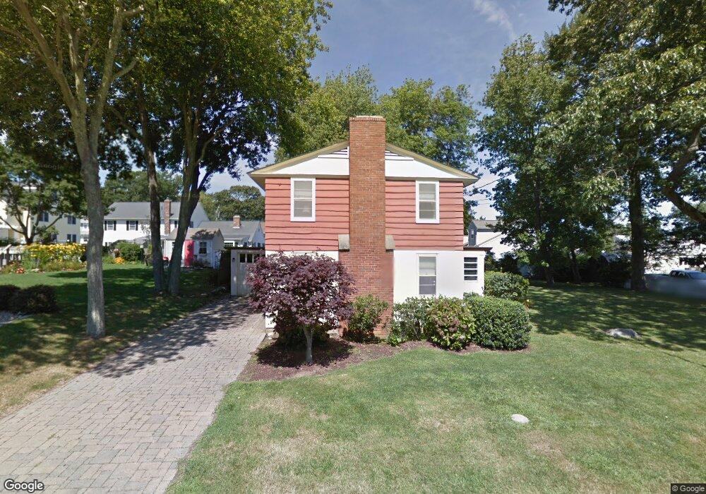
11 Whitecap Rd Niantic, CT 06357
Estimated Value: $312,000 - $733,000
4
Beds
2
Baths
1,388
Sq Ft
$416/Sq Ft
Est. Value
About This Home
This home is located at 11 Whitecap Rd, Niantic, CT 06357 and is currently estimated at $577,918, approximately $416 per square foot. 11 Whitecap Rd is a home located in New London County with nearby schools including East Lyme Middle School, East Lyme High School, and The Light House Voc-Ed Center.
Ownership History
Date
Name
Owned For
Owner Type
Purchase Details
Closed on
Apr 17, 2025
Sold by
Mackay T T and Mackay Salzarulo
Bought by
Mackay John L and Mackay Lindsey M
Current Estimated Value
Purchase Details
Closed on
Mar 4, 2025
Sold by
Anders E Hogblom T E and Anders Hogblom
Bought by
Mackay T T and Mackay Salzarulo
Purchase Details
Closed on
Jan 12, 2023
Sold by
Parmelee Sylvia H
Bought by
Mackay John L and Mackay Lindsey M
Purchase Details
Closed on
Oct 7, 1980
Bought by
Mackay June H
Create a Home Valuation Report for This Property
The Home Valuation Report is an in-depth analysis detailing your home's value as well as a comparison with similar homes in the area
Home Values in the Area
Average Home Value in this Area
Purchase History
| Date | Buyer | Sale Price | Title Company |
|---|---|---|---|
| Mackay John L | -- | None Available | |
| Mackay John L | -- | None Available | |
| Mackay T T | -- | None Available | |
| Mackay T T | -- | None Available | |
| Mackay John L | $150,000 | None Available | |
| Mackay John L | $150,000 | None Available | |
| Mackay June H | -- | -- |
Source: Public Records
Tax History
| Year | Tax Paid | Tax Assessment Tax Assessment Total Assessment is a certain percentage of the fair market value that is determined by local assessors to be the total taxable value of land and additions on the property. | Land | Improvement |
|---|---|---|---|---|
| 2025 | $7,260 | $259,210 | $178,150 | $81,060 |
| 2024 | $6,830 | $259,210 | $178,150 | $81,060 |
| 2023 | $6,449 | $259,210 | $178,150 | $81,060 |
| 2022 | $6,180 | $259,210 | $178,150 | $81,060 |
| 2021 | $6,159 | $216,020 | $154,420 | $61,600 |
| 2020 | $6,126 | $216,020 | $154,420 | $61,600 |
| 2019 | $6,090 | $216,020 | $154,420 | $61,600 |
| 2018 | $5,908 | $216,020 | $154,420 | $61,600 |
| 2017 | $5,651 | $216,020 | $154,420 | $61,600 |
| 2016 | $5,585 | $220,220 | $154,420 | $65,800 |
| 2015 | $5,442 | $220,220 | $154,420 | $65,800 |
| 2014 | $5,292 | $220,220 | $154,420 | $65,800 |
Source: Public Records
Map
Nearby Homes
- 61 Whitecap Rd
- 36 Attawan Rd
- 26 Mohawk Dr
- 127 Black Point Rd Unit 7
- 42 S Washington Ave
- 15 Griswold Rd
- 19 Sapia Dr
- 12 Spinnaker Dr
- 468 Main St Unit 318
- 468 Main St Unit 111
- 31 Regatta Dr
- 43 Village Crossing Unit 43
- 18 Compass Ct
- 47 Village Crossing Unit 47
- 46 Village Crossing Unit 46
- 97 W Main St Unit 36
- 185 Main St Unit 301
- 185 Main St Unit 305
- 55 Corey Ln
- 43 Roxbury Ct
- 9 Whitecap Rd
- 13 Whitecap Rd
- 14 Indianola Rd
- 12 Indianola Rd
- 7 Whitecap Rd
- 10 Whitecap Rd
- 16 Indianola Rd
- 15 Whitecap Rd
- 5 Whitecap Rd
- 8 Indianola Rd
- 14 Whitecap Rd
- 18 Indianola Rd
- 17 Whitecap Rd
- 31 E Shore Dr
- 13 Indianola Rd
- 13 Sea Breeze Ave
- 11 Indianola Rd
- 9 Sea Breeze Ave
- 15 Indianola Rd
- 15 Sea Breeze Ave
Your Personal Tour Guide
Ask me questions while you tour the home.