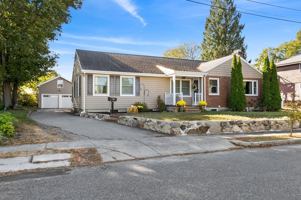
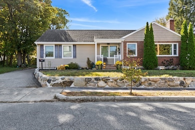
11 Wilson Ave Wakefield, MA 01880
Montrose NeighborhoodEstimated payment $5,010/month
Highlights
- In Ground Pool
- Property is near public transit
- Wood Flooring
- Open Floorplan
- Ranch Style House
- Bonus Room
About This Home
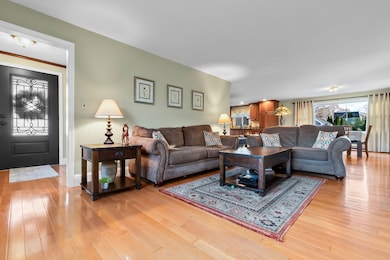
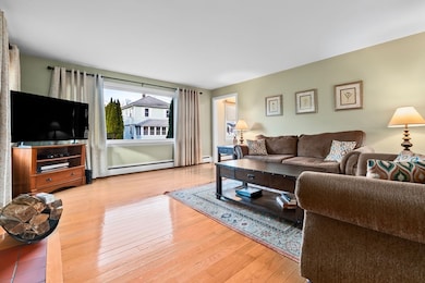
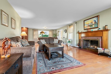
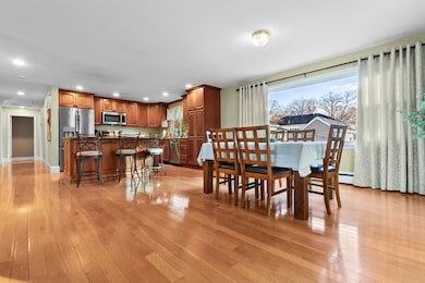
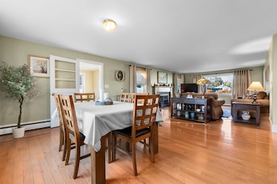
Presenting... an expansive 4 BR, 2 bath Ranch nestled on a tranquil street in popular Wakefield w/ over 3,200 sf of living space designed to accommodate an expanded family/multigenerational living. Inside, discover a beautifully renovated kitchen & bath w/ modern finishes that blend seamlessly w/ the open floor plan. The home boasts gorgeous hardwood floors, complemented by newer windows & durable vinyl siding. Outside is just as enticing, w/ new garage doors leading to a 2-car garage complete w/ a loft for add’l storage. 2 sheds provide space for hobbyists or a workshop. The private backyard is an oasis, w/ an in-ground pool perfect for summer fun & plenty of space for BBQs. Wakefield’s vibrant downtown brims w/ fabulous restaurants & shops. Walk/jog around picturesque Lake Quannapowitt & take advantage of the convenient commuter rail service to/from Boston. Easy access to major highways. Experience the perfect blend of comfort, convenience, & community & make this home yours today!
Home Details
Home Type
- Single Family
Est. Annual Taxes
- $9,573
Year Built
- Built in 1955 | Remodeled
Lot Details
- 0.33 Acre Lot
- Fenced Yard
- Property is zoned SR
Parking
- 2 Car Detached Garage
- Driveway
- Open Parking
- Off-Street Parking
Home Design
- Ranch Style House
- Frame Construction
- Shingle Roof
- Concrete Perimeter Foundation
Interior Spaces
- Open Floorplan
- Ceiling Fan
- Recessed Lighting
- Light Fixtures
- Picture Window
- Living Room with Fireplace
- Combination Dining and Living Room
- Bonus Room
Kitchen
- Stove
- Range
- Dishwasher
- Stainless Steel Appliances
- Kitchen Island
- Solid Surface Countertops
- Disposal
Flooring
- Wood
- Ceramic Tile
- Vinyl
Bedrooms and Bathrooms
- 4 Bedrooms
- 2 Full Bathrooms
- Bathtub with Shower
- Separate Shower
Laundry
- Laundry on main level
- Washer Hookup
Finished Basement
- Walk-Out Basement
- Basement Fills Entire Space Under The House
- Interior and Exterior Basement Entry
- Sump Pump
Outdoor Features
- In Ground Pool
- Outdoor Storage
- Rain Gutters
- Porch
Location
- Property is near public transit
- Property is near schools
Schools
- Galvin Middle School
- Wakefield High School
Utilities
- No Cooling
- Heating System Uses Natural Gas
- Baseboard Heating
- Gas Water Heater
Listing and Financial Details
- Assessor Parcel Number M:000029 B:0114 P:0B68BA,821151
Community Details
Overview
- No Home Owners Association
Amenities
- Shops
- Coin Laundry
Recreation
- Jogging Path
Map
Home Values in the Area
Average Home Value in this Area
Tax History
| Year | Tax Paid | Tax Assessment Tax Assessment Total Assessment is a certain percentage of the fair market value that is determined by local assessors to be the total taxable value of land and additions on the property. | Land | Improvement |
|---|---|---|---|---|
| 2025 | $9,573 | $843,400 | $408,900 | $434,500 |
| 2024 | $9,435 | $838,700 | $406,600 | $432,100 |
| 2023 | $8,991 | $766,500 | $370,800 | $395,700 |
| 2022 | $8,623 | $699,900 | $337,700 | $362,200 |
| 2021 | $8,431 | $662,300 | $315,400 | $346,900 |
| 2020 | $7,905 | $619,000 | $294,800 | $324,200 |
| 2019 | $7,489 | $583,700 | $280,300 | $303,400 |
| 2018 | $6,972 | $538,400 | $258,600 | $279,800 |
| 2017 | $6,557 | $503,200 | $241,700 | $261,500 |
| 2016 | $6,576 | $487,500 | $228,900 | $258,600 |
| 2015 | $6,158 | $456,800 | $213,900 | $242,900 |
| 2014 | $5,622 | $439,900 | $205,700 | $234,200 |
Property History
| Date | Event | Price | List to Sale | Price per Sq Ft |
|---|---|---|---|---|
| 12/01/2025 12/01/25 | For Sale | $799,900 | -- | $246 / Sq Ft |
Purchase History
| Date | Type | Sale Price | Title Company |
|---|---|---|---|
| Deed | $480,000 | -- |
Mortgage History
| Date | Status | Loan Amount | Loan Type |
|---|---|---|---|
| Open | $134,000 | Purchase Money Mortgage |
Source: MLS Property Information Network (MLS PIN)
MLS Number: 73458612
APN: WAKE-000029-000114-B000068BA
Disclaimer: Certain information contained herein is derived from information provided by parties other than Homes.com. All information provided is deemed reliable, but is not guaranteed to be accurate and should be independently verified.
![]() The property listing data and information, or the Images, set forth herein were provided to MLS Property Information Network, Inc. from third party sources, including sellers, lessors and public records, and were compiled by MLS Property Information Network, Inc. The property listing data and information, and the Images, are for the personal, non-commercial use of consumers having a good faith interest in purchasing or leasing listed properties of the type displayed to them and may not be used for any purpose other than to identify prospective properties which such consumers may have a good faith interest in purchasing or leasing. MLS Property Information Network, Inc. and its subscribers disclaim any and all representations and warranties as to the accuracy of the property listing data and information, or as to the accuracy of any of the Images, set forth herein.
The property listing data and information, or the Images, set forth herein were provided to MLS Property Information Network, Inc. from third party sources, including sellers, lessors and public records, and were compiled by MLS Property Information Network, Inc. The property listing data and information, and the Images, are for the personal, non-commercial use of consumers having a good faith interest in purchasing or leasing listed properties of the type displayed to them and may not be used for any purpose other than to identify prospective properties which such consumers may have a good faith interest in purchasing or leasing. MLS Property Information Network, Inc. and its subscribers disclaim any and all representations and warranties as to the accuracy of the property listing data and information, or as to the accuracy of any of the Images, set forth herein.
- 6 Blue Jay Cir Unit 2
- 314 Water St Unit 5
- 9 Nelson Ave
- 16 Pleasant St
- 11 Muriel Ave
- 1 Millbrook Ln Unit 111
- 1 Millbrook Ln Unit 304
- 22 Wayland Rd
- 24 Park St
- 5 Bateman Ct Unit 5
- 3 Garden Ln
- 51 Crescent St
- 22 Jefferson Rd
- 142 Montrose Ave
- 48 Cordis St
- 38 Bennett St Unit 3D
- 14 Sycamore Rd
- 199 Nahant St
- 134 Nahant St Unit B
- 9 Avon St Unit 2
- 2 Blue Jay Cir Unit 1
- 246 Salem St
- 246 Salem St
- 259 Water St Unit 101
- 2 Melvin St Unit 2
- 34 Salem St Unit 2
- 52 Valley St
- 10 Wakefield Ave
- 10 Wakefield Ave
- 10 Wakefield Ave
- 10 Roosevelt Rd
- 43 Crescent St Unit 43
- 27-37 Water St
- 34 Richardson St Unit 2
- 40 Avon St Unit 2
- 22 Sweetser St Unit 1
- 15 Sycamore Rd
- 554 Main St Unit 2
- 22 Yale Ave Unit A
- 27 W Water St Unit 211
