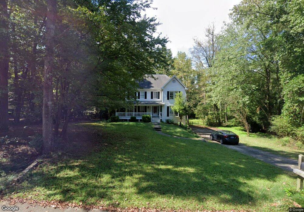
110 Autumn Trace Tyrone, GA 30290
Estimated Value: $437,573 - $497,000
Studio
1
Bath
2,158
Sq Ft
$218/Sq Ft
Est. Value
About This Home
This home is located at 110 Autumn Trace, Tyrone, GA 30290 and is currently estimated at $469,393, approximately $217 per square foot. 110 Autumn Trace is a home located in Fayette County with nearby schools including Crabapple Lane Elementary School, Flat Rock Middle School, and Sandy Creek High School.
Ownership History
Date
Name
Owned For
Owner Type
Purchase Details
Closed on
Mar 14, 2008
Sold by
Phillips Rick and Phillips Michaela M
Bought by
Ream Robert D
Current Estimated Value
Home Financials for this Owner
Home Financials are based on the most recent Mortgage that was taken out on this home.
Original Mortgage
$193,500
Outstanding Balance
$117,544
Interest Rate
5.62%
Mortgage Type
New Conventional
Estimated Equity
$351,849
Purchase Details
Closed on
Jun 20, 2003
Sold by
Stell Wm Keith and Stell Jill S
Bought by
Phillips Micheala M and Phillips Rick
Home Financials for this Owner
Home Financials are based on the most recent Mortgage that was taken out on this home.
Original Mortgage
$166,800
Interest Rate
5.3%
Mortgage Type
New Conventional
Create a Home Valuation Report for This Property
The Home Valuation Report is an in-depth analysis detailing your home's value as well as a comparison with similar homes in the area
Home Values in the Area
Average Home Value in this Area
Purchase History
| Date | Buyer | Sale Price | Title Company |
|---|---|---|---|
| Ream Robert D | $215,000 | -- | |
| Phillips Micheala M | $208,500 | -- |
Source: Public Records
Mortgage History
| Date | Status | Borrower | Loan Amount |
|---|---|---|---|
| Open | Ream Robert D | $193,500 | |
| Previous Owner | Phillips Micheala M | $166,800 |
Source: Public Records
Tax History
| Year | Tax Paid | Tax Assessment Tax Assessment Total Assessment is a certain percentage of the fair market value that is determined by local assessors to be the total taxable value of land and additions on the property. | Land | Improvement |
|---|---|---|---|---|
| 2025 | $3,545 | $161,514 | $29,960 | $131,554 |
| 2024 | $3,451 | $150,948 | $28,000 | $122,948 |
| 2023 | $2,982 | $144,960 | $28,000 | $116,960 |
| 2022 | $3,157 | $124,240 | $28,000 | $96,240 |
| 2021 | $2,934 | $106,080 | $19,000 | $87,080 |
| 2020 | $3,029 | $99,480 | $19,000 | $80,480 |
| 2019 | $3,087 | $100,400 | $19,000 | $81,400 |
| 2018 | $2,976 | $95,880 | $19,000 | $76,880 |
| 2017 | $2,686 | $86,480 | $19,000 | $67,480 |
| 2016 | $2,471 | $78,240 | $19,000 | $59,240 |
| 2015 | $2,781 | $86,320 | $19,000 | $67,320 |
| 2014 | $2,488 | $76,240 | $19,000 | $57,240 |
| 2013 | -- | $74,320 | $0 | $0 |
Source: Public Records
Map
Nearby Homes
- 100 Clydesdale Ct
- 130 Windchime Way Unit 9
- 150 Kylemore Pass
- 135 Arabian
- 200 Chaparral Trace
- 108 Tullamore Trail
- 28 Border Point
- 113 Creggan Hill Ct
- 121 Northwoods Rd
- 80 Northwoods Rd
- 535 Laurelwood Dr
- 235 Ashmere Ct
- 105 Laurel Forest Dr
- 100 Leisure Trail
- 135 French Village Blvd
- 321 Cottonwood Cir
- 152 Ardenlee Dr
- 1103 Maybeck Way
- 134 Ardenlee Dr
- 125 Meadowview Cir
- 330 Ashland Trail Unit 47
- 330 Ashland Trail
- 320 Ashland Trail
- 120 Autumn Trace
- 115 Autumn Trace
- 125 Autumn Trace
- 130 Autumn Trace
- 340 Ashland Trail
- 115 Crimson Ridge
- 315 Ashland Trail
- 335 Ashland Trail
- 325 Ashland Trail
- 345 Ashland Trail
- 952 Dogwood Trail
- 135 Crimson Ridge
- 350 Ashland Trail
- 109 Crimson Ridge
- 109 Crimson Ridge Unit 50
- 355 Ashland Trail
- 105 Crimson Ridge
Your Personal Tour Guide
Ask me questions while you tour the home.