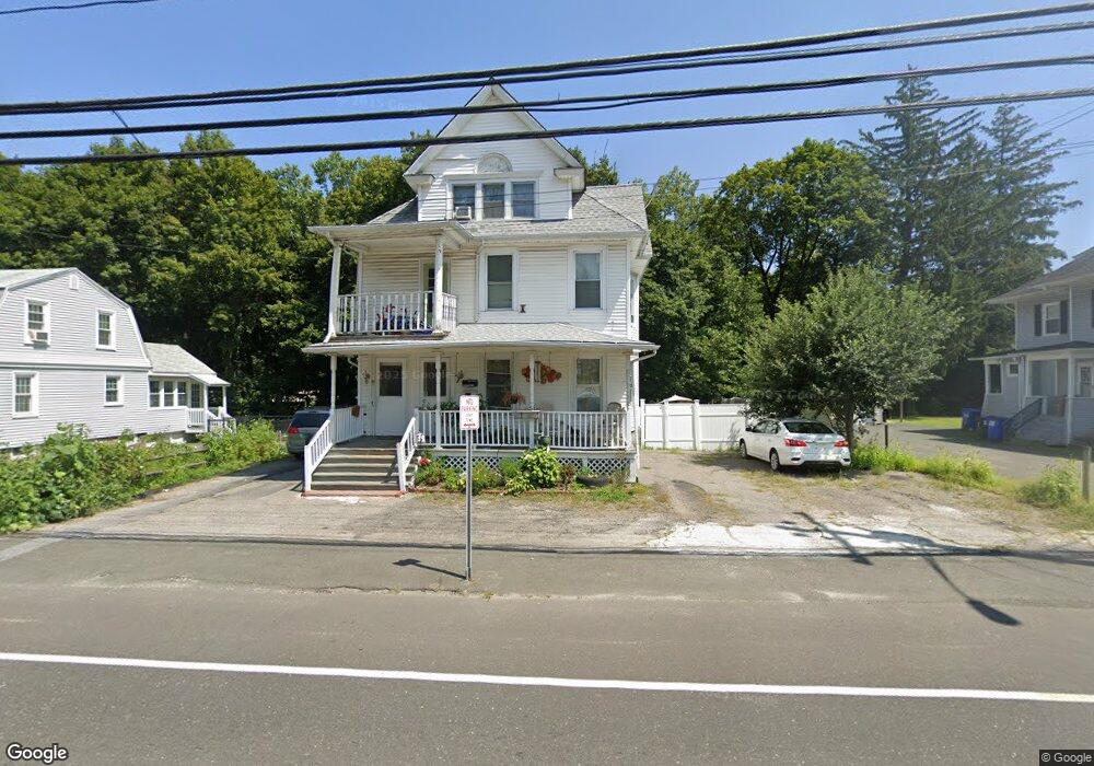
110 N Main St Winsted, CT 06098
Estimated Value: $244,352 - $364,000
8
Beds
3
Baths
3,084
Sq Ft
$98/Sq Ft
Est. Value
About This Home
This home is located at 110 N Main St, Winsted, CT 06098 and is currently estimated at $300,838, approximately $97 per square foot. 110 N Main St is a home located in Litchfield County with nearby schools including Explorations Charter School, St Anthony School, and The Gilbert School.
Ownership History
Date
Name
Owned For
Owner Type
Purchase Details
Closed on
Jul 20, 1999
Sold by
Bensle Marion F
Bought by
Martinez Edward C and Martinez Juana M
Current Estimated Value
Home Financials for this Owner
Home Financials are based on the most recent Mortgage that was taken out on this home.
Original Mortgage
$83,900
Outstanding Balance
$23,186
Interest Rate
7.39%
Estimated Equity
$277,652
Create a Home Valuation Report for This Property
The Home Valuation Report is an in-depth analysis detailing your home's value as well as a comparison with similar homes in the area
Home Values in the Area
Average Home Value in this Area
Purchase History
| Date | Buyer | Sale Price | Title Company |
|---|---|---|---|
| Martinez Edward C | $84,000 | -- | |
| Martinez Edward C | $84,000 | -- |
Source: Public Records
Mortgage History
| Date | Status | Borrower | Loan Amount |
|---|---|---|---|
| Open | Martinez Edward C | $83,900 | |
| Closed | Martinez Edward C | $83,900 | |
| Previous Owner | Martinez Edward C | $25,000 |
Source: Public Records
Tax History Compared to Growth
Tax History
| Year | Tax Paid | Tax Assessment Tax Assessment Total Assessment is a certain percentage of the fair market value that is determined by local assessors to be the total taxable value of land and additions on the property. | Land | Improvement |
|---|---|---|---|---|
| 2025 | $3,379 | $115,850 | $22,260 | $93,590 |
| 2024 | $3,156 | $115,850 | $22,260 | $93,590 |
| 2023 | $3,057 | $115,850 | $22,260 | $93,590 |
| 2022 | $2,897 | $86,380 | $16,170 | $70,210 |
| 2021 | $2,897 | $86,380 | $16,170 | $70,210 |
| 2020 | $2,897 | $86,380 | $16,170 | $70,210 |
| 2019 | $2,897 | $86,380 | $16,170 | $70,210 |
| 2018 | $2,897 | $86,380 | $16,170 | $70,210 |
| 2017 | $2,939 | $87,640 | $16,170 | $71,470 |
| 2016 | $2,939 | $87,640 | $16,170 | $71,470 |
| 2015 | $2,866 | $87,640 | $16,170 | $71,470 |
| 2014 | $2,797 | $87,640 | $16,170 | $71,470 |
Source: Public Records
Map
Nearby Homes
- 116 N Main St
- 135 N Main St
- 0 N Main St Unit 24111564
- 0 N Main St Unit 170620642
- 0 N Main St Unit 170469982
- 0 N Main St Unit 170178403
- 180 Holabird Ave
- 163 Holabird Ave
- 143 N Main St
- 143 Wetmore Ave
- 139 N Main St
- 139 N Main St Unit 2
- 139 N Main St Unit LL
- 139 N Main St Unit 3
- 158 Holabird Ave
- 14 N Main St
- 153 Holabird Ave
- 153 Wetmore Ave
- 144 Wetmore Ave
- 144 Wetmore Ave Unit 2