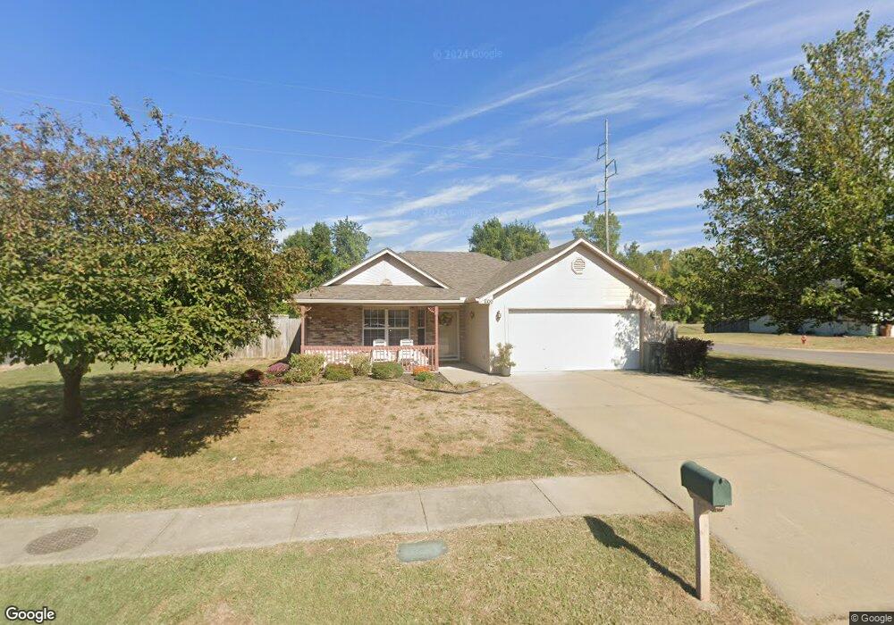
1100 SW Blue Branch Dr Grain Valley, MO 64029
Estimated Value: $269,000 - $294,000
3
Beds
2
Baths
1,268
Sq Ft
$218/Sq Ft
Est. Value
About This Home
This home is located at 1100 SW Blue Branch Dr, Grain Valley, MO 64029 and is currently estimated at $275,972, approximately $217 per square foot. 1100 SW Blue Branch Dr is a home located in Jackson County with nearby schools including Grain Valley High School.
Ownership History
Date
Name
Owned For
Owner Type
Purchase Details
Closed on
Feb 5, 2013
Sold by
Rozell Joseph F and Rozell Frances
Bought by
Rozell Joseph F and Rozell Frances
Current Estimated Value
Home Financials for this Owner
Home Financials are based on the most recent Mortgage that was taken out on this home.
Original Mortgage
$62,000
Outstanding Balance
$27,986
Interest Rate
3.39%
Mortgage Type
New Conventional
Estimated Equity
$247,986
Purchase Details
Closed on
Jun 14, 2011
Sold by
Rozell Joseph F and Rozell Frances
Bought by
Rozell Joseph F and Rozell William P
Purchase Details
Closed on
Jan 14, 2000
Sold by
Lafal Swope Inc
Bought by
Smith Kenneth L and Smith Mandi S
Home Financials for this Owner
Home Financials are based on the most recent Mortgage that was taken out on this home.
Original Mortgage
$95,545
Interest Rate
7.84%
Mortgage Type
Purchase Money Mortgage
Create a Home Valuation Report for This Property
The Home Valuation Report is an in-depth analysis detailing your home's value as well as a comparison with similar homes in the area
Home Values in the Area
Average Home Value in this Area
Purchase History
| Date | Buyer | Sale Price | Title Company |
|---|---|---|---|
| Rozell Joseph F | -- | Stewart Title | |
| Rozell Joseph F | -- | None Available | |
| Smith Kenneth L | -- | Stewart Title |
Source: Public Records
Mortgage History
| Date | Status | Borrower | Loan Amount |
|---|---|---|---|
| Open | Rozell Joseph F | $62,000 | |
| Closed | Smith Kenneth L | $95,545 |
Source: Public Records
Tax History Compared to Growth
Tax History
| Year | Tax Paid | Tax Assessment Tax Assessment Total Assessment is a certain percentage of the fair market value that is determined by local assessors to be the total taxable value of land and additions on the property. | Land | Improvement |
|---|---|---|---|---|
| 2025 | $2,758 | $33,921 | $6,219 | $27,702 |
| 2024 | $2,655 | $33,489 | $5,409 | $28,080 |
| 2023 | $2,655 | $33,490 | $3,557 | $29,933 |
| 2022 | $2,325 | $25,650 | $3,816 | $21,834 |
| 2021 | $2,271 | $25,650 | $3,816 | $21,834 |
| 2020 | $2,307 | $25,702 | $3,816 | $21,886 |
| 2019 | $2,260 | $25,702 | $3,816 | $21,886 |
| 2018 | $1,561,026 | $22,369 | $3,321 | $19,048 |
| 2017 | $2,105 | $22,369 | $3,321 | $19,048 |
| 2016 | $1,952 | $20,756 | $3,519 | $17,237 |
| 2014 | $1,928 | $20,349 | $3,450 | $16,899 |
Source: Public Records
Map
Nearby Homes
- 1024 Christie Ln
- 200 Cross Creek Ln
- 1418 SW Blue Branch Dr
- 209 SW Cross Creek Dr
- 207 Pebblebrook St
- 509 SW Joseph Ct
- 401 S Minter Rd
- 1235 NW Ashley Ln
- 1229 NW Ashley Dr
- 636 SW Lakeview Dr
- 725 SW Tisha Ln
- 1215 SW Lone Star Ct
- 1007 NW Long Dr
- 518 South St
- 605 NW Silverstone Cir
- 640 SW Crestview Dr
- 1402 NW Broadway Throughway
- 1214 SW Windcrest Ct
- 714 SW Brome Dr
- 512 Broadway St
- 1102 SW Blue Branch Dr
- 1104 SW Blue Branch Dr
- 1003 SW Blue Branch Dr
- 1101 SW Blue Branch Dr
- 1109 SW Blue Branch Dr
- 1110 SW Blue Branch Dr
- 1103 SW Blue Branch Dr
- 1009 SW Blue Branch Dr
- 1107 SW Blue Branch Dr
- 1105 SW Blue Branch Dr
- 1112 SW Blue Branch Dr
- 1011 SW Blue Branch Dr
- 1111 SW Blue Branch Dr
- 1007 SW Blue Branch Dr
- 1114 SW Blue Branch Dr
- 1113 SW Blue Branch Dr
- 1036 Dean Dr
- 1040 Dean Dr
- 1100 Dean Dr
- 1042 Dean Dr