Estimated Value: $238,754 - $265,000
3
Beds
2
Baths
1,664
Sq Ft
$151/Sq Ft
Est. Value
About This Home
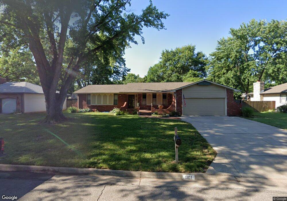
This home is located at 1101 E Post Oak St, Derby, KS 67037 and is currently estimated at $251,877, approximately $151 per square foot. 1101 E Post Oak St is a home located in Sedgwick County with nearby schools including Swaney Elementary School, Derby Middle School, and Derby High School.
Ownership History
Date
Name
Owned For
Owner Type
Purchase Details
Closed on
Jun 26, 2020
Sold by
Lollar Lonnie A and Lollar Patricia A
Bought by
Goings Chad Michael and Goings Lauren Ann
Current Estimated Value
Home Financials for this Owner
Home Financials are based on the most recent Mortgage that was taken out on this home.
Original Mortgage
$160,000
Outstanding Balance
$141,877
Interest Rate
3.1%
Mortgage Type
New Conventional
Estimated Equity
$110,000
Purchase Details
Closed on
May 18, 2000
Sold by
Car Lon Oil & Gas Company
Bought by
Lollar Lonnie A and Lollar Patricia A
Create a Home Valuation Report for This Property
The Home Valuation Report is an in-depth analysis detailing your home's value as well as a comparison with similar homes in the area
Home Values in the Area
Average Home Value in this Area
Purchase History
| Date | Buyer | Sale Price | Title Company |
|---|---|---|---|
| Goings Chad Michael | -- | Security 1St Title Llc | |
| Lollar Lonnie A | -- | -- |
Source: Public Records
Mortgage History
| Date | Status | Borrower | Loan Amount |
|---|---|---|---|
| Open | Goings Chad Michael | $160,000 |
Source: Public Records
Tax History
| Year | Tax Paid | Tax Assessment Tax Assessment Total Assessment is a certain percentage of the fair market value that is determined by local assessors to be the total taxable value of land and additions on the property. | Land | Improvement |
|---|---|---|---|---|
| 2025 | $3,194 | $25,048 | $5,624 | $19,424 |
| 2023 | $3,194 | $23,633 | $3,554 | $20,079 |
| 2022 | $3,097 | $21,954 | $3,347 | $18,607 |
| 2021 | $2,946 | $20,521 | $3,347 | $17,174 |
| 2020 | $2,810 | $19,539 | $3,347 | $16,192 |
| 2019 | $2,602 | $18,090 | $3,347 | $14,743 |
| 2018 | $2,518 | $17,561 | $2,312 | $15,249 |
| 2017 | $2,312 | $0 | $0 | $0 |
| 2016 | $2,179 | $0 | $0 | $0 |
| 2015 | $2,207 | $0 | $0 | $0 |
| 2014 | $2,118 | $0 | $0 | $0 |
Source: Public Records
Map
Nearby Homes
- 327 N Willow Dr
- 1401 E Carolyn St
- 1111 E Redwood Rd
- 1213 E Brook Forest Ct
- 2 S Woodlawn Blvd
- 1518 E Carolyn St
- 500 S Sharon Ct
- 452 S Spring Creek Dr
- 854 N Beaver Trail Rd
- 1312 E Pine Tree Rd
- 519 S Partridge Ln
- 329 N Sarah Ct
- 1625 E Tiara Pines St
- 718 N Sumac Rd
- 1525 E Pheasant Run St
- 1413 E Cresthill Rd
- 101 N Crosswood Ln
- 129 S Kokomo Ave
- 1000 N El Paso Dr
- 1613 E Brendonwood Rd
- 1019 E Post Oak St
- 1107 E Post Oak St
- 1100 E Post Oak St
- 1018 E Post Oak St
- 1100 E Cottonwood Rd
- 1013 E Post Oak St
- 1106 E Post Oak St
- 1018 E Cottonwood Rd
- 1113 E Post Oak St
- 1106 E Cottonwood Rd
- 1112 E Post Oak St
- 1012 E Cottonwood Rd
- 1012 E Post Oak St
- 1112 E Cottonwood Rd
- 1007 E Post Oak St
- 307 N Brookwood Dr
- 1006 E Cottonwood Rd
- 1101 E Cottonwood Rd
- 1006 E Post Oak St
- 315 N Brookwood Dr
Your Personal Tour Guide
Ask me questions while you tour the home.