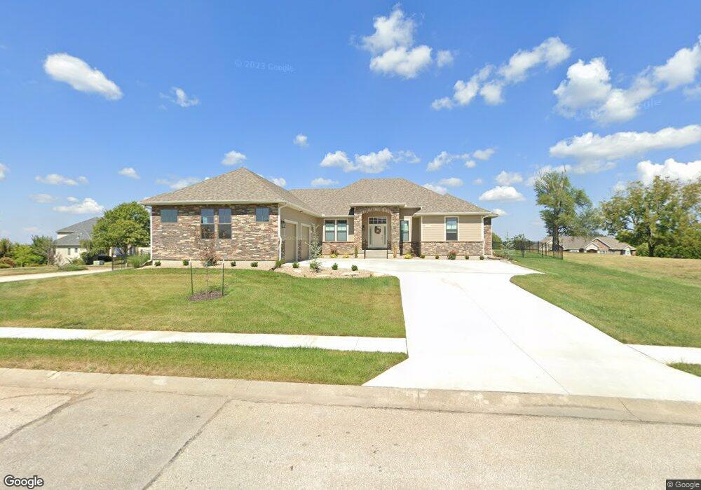
1101 Saxony Ct Warrensburg, MO 64093
Estimated Value: $322,000 - $639,000
--
Bed
--
Bath
4,115
Sq Ft
$127/Sq Ft
Est. Value
About This Home
This home is located at 1101 Saxony Ct, Warrensburg, MO 64093 and is currently estimated at $524,548, approximately $127 per square foot. 1101 Saxony Ct is a home with nearby schools including Ridge View Elementary School, Sterling Elementary School, and Warrensburg Middle School.
Ownership History
Date
Name
Owned For
Owner Type
Purchase Details
Closed on
Oct 11, 2022
Sold by
Wade Sammy H and Wade Robin G
Bought by
Woodard Phillip D and Woodard Carolyn L
Current Estimated Value
Purchase Details
Closed on
Nov 1, 2019
Sold by
Weatherstone Development Llc
Bought by
Norton Charles and Norton Allison
Home Financials for this Owner
Home Financials are based on the most recent Mortgage that was taken out on this home.
Original Mortgage
$112,706
Interest Rate
3.7%
Mortgage Type
Future Advance Clause Open End Mortgage
Purchase Details
Closed on
Apr 14, 2014
Sold by
Swisher Richard A and Swisher Lisa M
Bought by
Wade Sammy H and Wade Robin G
Purchase Details
Closed on
Oct 4, 2005
Sold by
Maxson Virginia G and Maxson Tristan R
Bought by
Swisher Richard A and Swisher Lisa M
Purchase Details
Closed on
Jul 1, 2005
Sold by
Younger Ralph E and Younger Linda L
Bought by
Maxson Virginia G and Maxson Tristan R
Create a Home Valuation Report for This Property
The Home Valuation Report is an in-depth analysis detailing your home's value as well as a comparison with similar homes in the area
Home Values in the Area
Average Home Value in this Area
Purchase History
| Date | Buyer | Sale Price | Title Company |
|---|---|---|---|
| Woodard Phillip D | $3,000 | -- | |
| Norton Charles | -- | None Available | |
| Wade Sammy H | -- | None Available | |
| Swisher Richard A | -- | Johnson County Title Company | |
| Maxson Virginia G | -- | None Available |
Source: Public Records
Mortgage History
| Date | Status | Borrower | Loan Amount |
|---|---|---|---|
| Previous Owner | Norton Charles | $112,706 |
Source: Public Records
Tax History Compared to Growth
Tax History
| Year | Tax Paid | Tax Assessment Tax Assessment Total Assessment is a certain percentage of the fair market value that is determined by local assessors to be the total taxable value of land and additions on the property. | Land | Improvement |
|---|---|---|---|---|
| 2024 | $5,141 | $67,327 | $0 | $0 |
| 2023 | $5,141 | $475 | $0 | $0 |
| 2022 | $36 | $475 | $0 | $0 |
| 2021 | $36 | $475 | $0 | $0 |
| 2020 | $37 | $475 | $0 | $0 |
| 2019 | $37 | $475 | $0 | $0 |
| 2017 | $37 | $475 | $0 | $0 |
| 2016 | $34 | $475 | $0 | $0 |
| 2015 | $35 | $475 | $0 | $0 |
| 2014 | -- | $475 | $0 | $0 |
Source: Public Records
Map
Nearby Homes
- 1002 Weschester Ct
- 1510 Coventry Ct
- 1506 Coventry Ct
- 1508 Coventry Ct
- 1509 Coventry Ct
- 1507 Coventry Ct
- 1505 Coventry Ct
- 1503 Coventry Ct
- 1421 Grandview Dr
- 1406 Grandview Dr
- 1410 Grandview Dr
- 1090 Pebblecreek Dr
- 1092 Pebblecreek Dr
- 1094 Pebblecreek Dr
- 1096 Pebblecreek Dr
- 1098 Pebblecreek Dr
- 1504 Park Ave
- 135 Cedar Ct
- 1506 Park Ave
- 134 Cedar Ct
- 0 Manitou Way Dr
- 1205 Manitou Way Dr
- 1201 Manitou Way Dr
- 1106 Saxony Ct
- 1204 Manitou Way Dr
- 1200 Manitou Way Dr
- 1208 Manitou Way Dr
- 1108 Kismet St
- 1108 Kismet Dr
- Lot 12 Kismet Dr
- 1108 Saxony Ct
- 1101 Kismet Dr
- 1101 Kismet St
- 1301 Manitou Ct
- 1005 Quincy Dr
- 1103 Kismet St
- 1003 Quincy Dr
- 0 Manitou Way Ct
- 1007 Quincy Dr
- 1001 Quincy Dr