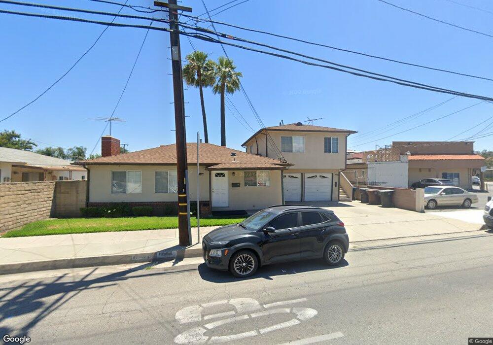
11018 Bryant Rd El Monte, CA 91731
Norwood Cherrylee NeighborhoodEstimated Value: $781,099 - $891,000
3
Beds
2
Baths
1,911
Sq Ft
$439/Sq Ft
Est. Value
About This Home
This home is located at 11018 Bryant Rd, El Monte, CA 91731 and is currently estimated at $839,275, approximately $439 per square foot. 11018 Bryant Rd is a home located in Los Angeles County with nearby schools including Legore Elementary School, Wright Elementary School, and Arroyo High School.
Ownership History
Date
Name
Owned For
Owner Type
Purchase Details
Closed on
Oct 16, 2023
Sold by
Roth Family 1992 Revocable Trust
Bought by
Roth Family 1992 Revocable Trust and Roth
Current Estimated Value
Purchase Details
Closed on
Mar 14, 1994
Sold by
Roth Joseph M and Roth Grace A
Bought by
Roth Joseph M
Home Financials for this Owner
Home Financials are based on the most recent Mortgage that was taken out on this home.
Original Mortgage
$120,000
Interest Rate
7%
Create a Home Valuation Report for This Property
The Home Valuation Report is an in-depth analysis detailing your home's value as well as a comparison with similar homes in the area
Home Values in the Area
Average Home Value in this Area
Purchase History
| Date | Buyer | Sale Price | Title Company |
|---|---|---|---|
| Roth Family 1992 Revocable Trust | -- | None Listed On Document | |
| Roth Joseph M | -- | Guardian Title Company |
Source: Public Records
Mortgage History
| Date | Status | Borrower | Loan Amount |
|---|---|---|---|
| Previous Owner | Roth Joseph M | $120,000 |
Source: Public Records
Tax History
| Year | Tax Paid | Tax Assessment Tax Assessment Total Assessment is a certain percentage of the fair market value that is determined by local assessors to be the total taxable value of land and additions on the property. | Land | Improvement |
|---|---|---|---|---|
| 2025 | $1,971 | $104,130 | $37,163 | $66,967 |
| 2024 | $1,971 | $102,089 | $36,435 | $65,654 |
| 2023 | $1,935 | $100,088 | $35,721 | $64,367 |
| 2022 | $1,874 | $98,126 | $35,021 | $63,105 |
| 2021 | $1,876 | $96,203 | $34,335 | $61,868 |
| 2019 | $1,899 | $93,351 | $33,317 | $60,034 |
| 2018 | $1,806 | $91,521 | $32,664 | $58,857 |
| 2016 | $1,719 | $87,969 | $31,397 | $56,572 |
| 2015 | $1,698 | $86,649 | $30,926 | $55,723 |
| 2014 | $1,655 | $84,953 | $30,321 | $54,632 |
Source: Public Records
Map
Nearby Homes
- 3760 Esmeralda Ave
- 3813 Lincoln Ave
- 4014 Cedar Ave
- 11326 Forest Grove St
- 11040 Encanto Way
- 11135 Legion Dr Unit 101
- 11123 Legion Loop Unit 101
- 11130 Legion Loop Unit 105
- 11175 Legion Loop Unit 110
- 11211 Mcgirk Ave
- 4104 Elrovia Ave
- 10988 Las Flores Dr
- 3841 Peck Rd
- 11396 Mcgirk Ave
- 10679 Elmcrest St
- 4445 Halifax Rd
- 11450 Clover Ln
- 11446 Clover Ln
- 11427 Wildflower Ln
- 11440 Clover Ln
- 4033 Winston Dr
- 4022 Tyler Ave
- 11019 Bryant Rd
- 4102 Tyler Ave
- 4021 Winston Dr
- 4032 Winston Dr
- 4028 Winston Dr
- 4024 Winston Dr
- 11048 Bryant Rd
- 4020 Winston Dr
- 4013 Winston Dr
- 4016 Tyler Ave
- 4016 Winston Dr
- 4122 Tyler Ave
- 4012 Winston Dr
- 4005 Winston Dr
- 4015 Esmeralda Ave
- 4011 Esmeralda Ave
- 4019 Esmeralda Ave
- 4006 Tyler Ave
Your Personal Tour Guide
Ask me questions while you tour the home.