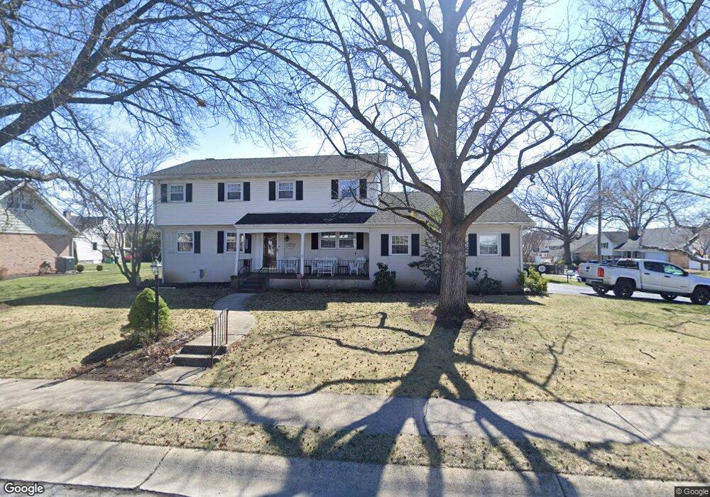
1102 Lilac Ln Reading, PA 19609
Whitfield NeighborhoodEstimated Value: $354,000 - $438,000
4
Beds
3
Baths
2,450
Sq Ft
$159/Sq Ft
Est. Value
About This Home
This home is located at 1102 Lilac Ln, Reading, PA 19609 and is currently estimated at $389,869, approximately $159 per square foot. 1102 Lilac Ln is a home located in Berks County with nearby schools including Whitfield Elementary School, Wilson West Middle School, and Wilson High School.
Ownership History
Date
Name
Owned For
Owner Type
Purchase Details
Closed on
May 16, 2002
Sold by
Smith Robert A and Smith Theresa A
Bought by
Smith Robert A and Smith Theresa A
Current Estimated Value
Home Financials for this Owner
Home Financials are based on the most recent Mortgage that was taken out on this home.
Original Mortgage
$35,000
Interest Rate
6.24%
Create a Home Valuation Report for This Property
The Home Valuation Report is an in-depth analysis detailing your home's value as well as a comparison with similar homes in the area
Home Values in the Area
Average Home Value in this Area
Purchase History
| Date | Buyer | Sale Price | Title Company |
|---|---|---|---|
| Smith Robert A | -- | Fidelity National Title Ins |
Source: Public Records
Mortgage History
| Date | Status | Borrower | Loan Amount |
|---|---|---|---|
| Closed | Smith Robert A | $35,000 |
Source: Public Records
Tax History
| Year | Tax Paid | Tax Assessment Tax Assessment Total Assessment is a certain percentage of the fair market value that is determined by local assessors to be the total taxable value of land and additions on the property. | Land | Improvement |
|---|---|---|---|---|
| 2025 | $2,544 | $141,100 | $38,700 | $102,400 |
| 2024 | $6,037 | $141,100 | $38,700 | $102,400 |
| 2023 | $5,752 | $141,100 | $38,700 | $102,400 |
| 2022 | $5,611 | $141,100 | $38,700 | $102,400 |
| 2021 | $5,414 | $141,100 | $38,700 | $102,400 |
| 2020 | $5,414 | $141,100 | $38,700 | $102,400 |
| 2019 | $5,260 | $141,100 | $38,700 | $102,400 |
| 2018 | $5,215 | $141,100 | $38,700 | $102,400 |
| 2017 | $5,126 | $141,100 | $38,700 | $102,400 |
| 2016 | $1,781 | $141,100 | $38,700 | $102,400 |
| 2015 | $1,781 | $141,100 | $38,700 | $102,400 |
| 2014 | $1,781 | $141,100 | $38,700 | $102,400 |
Source: Public Records
Map
Nearby Homes
- 2904 Gerard Ave
- 2300 Gring Dr
- 3107 Octagon Ave
- 3116 Linda Ln
- 504 Kutz Ct
- 3029 Grandview Blvd
- 3125 Merritt Pkwy Unit PY
- 130 Laurel Ct Unit 130B
- 132 Laurel Ct Unit 132A
- 3016 Belmont Ave
- 118 Laurel Ct Unit 118B
- 2900 State Hill Rd Unit I12
- 14 Laird St
- 162 Hawthorne Ct
- 3411 Penn Ave
- 1920 Andre Ct
- 101 Robert Rd
- 41 Dorchester Dr
- 103 Hawthorne Ct
- 120 Coventry Ln
- 2702 Craig Ave
- 1100 Lilac Ln
- 2703 Saint Albans Dr
- 1103 Lilac Ln
- 2704 Craig Ave
- 1105 Lilac Ln
- 1108 Lilac Ln
- 2703 Craig Ave
- 2603 Saint Albans Dr
- 2705 Saint Albans Dr
- 2705 Craig Ave
- 2706 Craig Ave
- 1109 Lilac Ln
- 1110 Lilac Ln
- 2707 Saint Albans Dr
- 1102 Dogwood Dr
- 1104 Dogwood Dr
- 2707 Craig Ave
- 1106 Dogwood Dr
- 2601 Saint Albans Dr
Your Personal Tour Guide
Ask me questions while you tour the home.