Estimated Value: $593,000 - $624,000
3
Beds
3
Baths
3,356
Sq Ft
$183/Sq Ft
Est. Value
About This Home
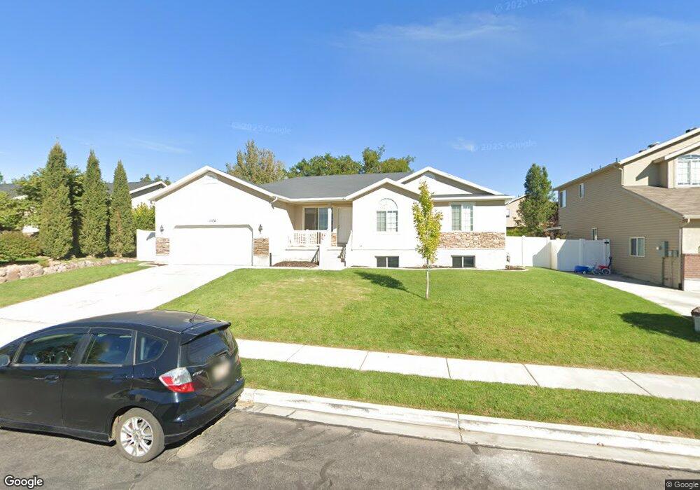
This home is located at 1102 N 1250 E, Lehi, UT 84043 and is currently estimated at $613,588, approximately $182 per square foot. 1102 N 1250 E is a home located in Utah County with nearby schools including Freedom Elementary School, Lehi Junior High School, and Skyridge High School.
Ownership History
Date
Name
Owned For
Owner Type
Purchase Details
Closed on
Jun 21, 2017
Sold by
Oak Wood Strategies Llc
Bought by
Oak Wood Strategies Traverse Lc
Current Estimated Value
Purchase Details
Closed on
May 19, 2017
Sold by
Wiest Thomas
Bought by
Oak Wood Strategies Llc
Purchase Details
Closed on
Oct 29, 2004
Sold by
Hallmark Homes & Development
Bought by
Wiest Thomas A
Home Financials for this Owner
Home Financials are based on the most recent Mortgage that was taken out on this home.
Original Mortgage
$166,217
Interest Rate
5.74%
Mortgage Type
Purchase Money Mortgage
Create a Home Valuation Report for This Property
The Home Valuation Report is an in-depth analysis detailing your home's value as well as a comparison with similar homes in the area
Home Values in the Area
Average Home Value in this Area
Purchase History
| Date | Buyer | Sale Price | Title Company |
|---|---|---|---|
| Oak Wood Strategies Traverse Lc | -- | Artisan Title | |
| Oak Wood Strategies Llc | -- | Artisan Title | |
| Wiest Thomas A | -- | Merrill Title Company |
Source: Public Records
Mortgage History
| Date | Status | Borrower | Loan Amount |
|---|---|---|---|
| Previous Owner | Wiest Thomas A | $166,217 |
Source: Public Records
Tax History
| Year | Tax Paid | Tax Assessment Tax Assessment Total Assessment is a certain percentage of the fair market value that is determined by local assessors to be the total taxable value of land and additions on the property. | Land | Improvement |
|---|---|---|---|---|
| 2025 | $2,480 | $311,190 | -- | -- |
| 2024 | $2,480 | $290,180 | $0 | $0 |
| 2023 | $2,334 | $296,560 | $0 | $0 |
| 2022 | $2,505 | $308,550 | $0 | $0 |
| 2021 | $2,241 | $417,300 | $131,100 | $286,200 |
| 2020 | $2,113 | $388,900 | $121,400 | $267,500 |
| 2019 | $1,850 | $354,000 | $121,400 | $232,600 |
| 2018 | $1,828 | $330,700 | $111,000 | $219,700 |
| 2017 | $1,752 | $168,520 | $0 | $0 |
| 2016 | $1,782 | $159,005 | $0 | $0 |
| 2015 | $1,863 | $157,850 | $0 | $0 |
| 2014 | $1,622 | $136,620 | $0 | $0 |
Source: Public Records
Map
Nearby Homes
- 1175 E 900 N
- 1272 N Cedar Hollow Blvd
- 893 N 1580 E
- 1370 N Cedar Hollow Blvd
- 890 N Whipple Dr
- 556 N 1440 E
- 9435 N Aspen Hollow Cir
- 499 N 1520 E
- 414 N 1322 E
- 4007 W 1000 N
- 3947 W 1000 N Unit 439
- 3971 W 1000 N Unit 441
- 3959 W 1000 N
- 3995 W 1000 N
- 822 N 860 W Unit 317
- 764 W 880 North St Unit 308
- 822 W 800 St N Unit LOT319
- 595 S 600 E
- 672 W 900 N
- 428 E 500 N
Your Personal Tour Guide
Ask me questions while you tour the home.