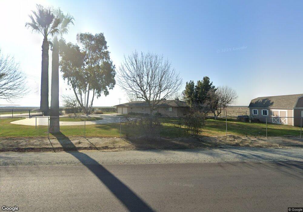
11027 W Manning Ave Fresno, CA 93706
Estimated Value: $426,000 - $498,000
3
Beds
2
Baths
1,587
Sq Ft
$286/Sq Ft
Est. Value
About This Home
This home is located at 11027 W Manning Ave, Fresno, CA 93706 and is currently estimated at $454,133, approximately $286 per square foot. 11027 W Manning Ave is a home located in Fresno County with nearby schools including Raisin City Elementary School.
Ownership History
Date
Name
Owned For
Owner Type
Purchase Details
Closed on
Oct 10, 2017
Sold by
Lehman Roger and Lehman Amy N
Bought by
Verwey John B and Verwey Ann M
Current Estimated Value
Purchase Details
Closed on
Apr 2, 2012
Sold by
Verwey John B and Verwey Ann M
Bought by
Lehman Roger and Lehman Amy N
Purchase Details
Closed on
Mar 4, 2008
Sold by
Hartwig Delores E
Bought by
Verwey John B and Verwey Ann M
Purchase Details
Closed on
Feb 11, 1999
Sold by
Hartwig and Betty
Bought by
Hartwig Ralph D and Hartwig Lawrence R
Create a Home Valuation Report for This Property
The Home Valuation Report is an in-depth analysis detailing your home's value as well as a comparison with similar homes in the area
Home Values in the Area
Average Home Value in this Area
Purchase History
| Date | Buyer | Sale Price | Title Company |
|---|---|---|---|
| Verwey John B | -- | None Available | |
| Lehman Roger | -- | None Available | |
| Verwey John B | $3,500,000 | Chicago Title Company | |
| Hartwig Ralph D | -- | Chicago Title Company | |
| Not Provided | -- | Chicago Title Company | |
| Hartwig Ralph D | $100,000 | -- |
Source: Public Records
Tax History Compared to Growth
Tax History
| Year | Tax Paid | Tax Assessment Tax Assessment Total Assessment is a certain percentage of the fair market value that is determined by local assessors to be the total taxable value of land and additions on the property. | Land | Improvement |
|---|---|---|---|---|
| 2025 | $3,124 | $296,181 | $91,937 | $204,244 |
| 2023 | $3,071 | $284,682 | $88,368 | $196,314 |
| 2022 | $3,030 | $279,101 | $86,636 | $192,465 |
| 2021 | $2,950 | $273,630 | $84,938 | $188,692 |
| 2020 | $2,450 | $225,000 | $65,000 | $160,000 |
| 2019 | $2,232 | $204,100 | $61,700 | $142,400 |
| 2018 | $2,195 | $200,200 | $60,500 | $139,700 |
| 2017 | $2,115 | $196,400 | $59,400 | $137,000 |
| 2016 | $2,015 | $189,953 | $57,463 | $132,490 |
| 2015 | $1,981 | $187,100 | $56,600 | $130,500 |
| 2014 | $1,873 | $175,200 | $53,000 | $122,200 |
Source: Public Records
Map
Nearby Homes
- 11203 W South Ave
- S Side of Lincoln Ave Unit btwn. Goldenrod & Bi
- 12250 S Jameson Ave
- 10420 Manning Ave
- 7455 W Lincoln Ave
- 5920 W Springfield Ave
- 9707 S Henderson Rd
- 2186 S Ivy Ave
- 9890 S Hayes Ave
- 2328 S Cherry Ave
- 0 S Madera Ave
- 9495 W Kamm Ave
- 13370 S Bryan Ave
- 10690 S Henderson Rd
- 6066 S Cornelia Ave
- 17946 W American Ave
- 15963 W Jensen Ave
- 0 North
- 0 S Marks Ave Unit 637440
- 0 From Manning Ave Unit .75 miles along E. s