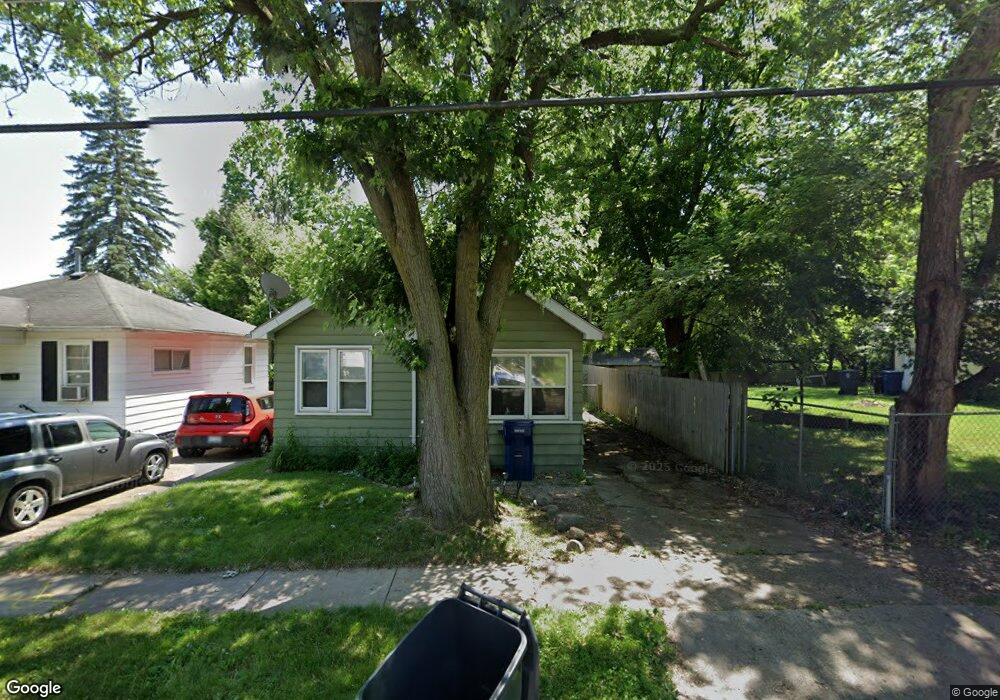
1105 Pinehurst Ave Flint, MI 48507
South Side NeighborhoodEstimated Value: $40,000 - $50,000
2
Beds
1
Bath
763
Sq Ft
$59/Sq Ft
Est. Value
About This Home
This home is located at 1105 Pinehurst Ave, Flint, MI 48507 and is currently estimated at $45,141, approximately $59 per square foot. 1105 Pinehurst Ave is a home located in Genesee County with nearby schools including Neithercut Elementary School, Flint Southwestern Classical Academy, and International Academy of Flint (K-12).
Ownership History
Date
Name
Owned For
Owner Type
Purchase Details
Closed on
Aug 21, 2025
Sold by
Jc Capital Funding Llc
Bought by
Bp Sfr Flint 1 Llc
Current Estimated Value
Purchase Details
Closed on
May 8, 2024
Sold by
Jc Capital Funding Llc and Jc Capital Funding Flint Llc
Bought by
Bp Sfr Flint 1 Llc
Purchase Details
Closed on
Jan 10, 2003
Sold by
Pearce Richard C and Pearce Maria
Bought by
Windom Michael J and Windom Mary J
Create a Home Valuation Report for This Property
The Home Valuation Report is an in-depth analysis detailing your home's value as well as a comparison with similar homes in the area
Home Values in the Area
Average Home Value in this Area
Purchase History
| Date | Buyer | Sale Price | Title Company |
|---|---|---|---|
| Bp Sfr Flint 1 Llc | $165,000 | None Listed On Document | |
| Bp Sfr Flint 1 Llc | -- | Dream Title & Escrow | |
| Windom Michael J | $43,500 | Metropolitan Title Company |
Source: Public Records
Tax History
| Year | Tax Paid | Tax Assessment Tax Assessment Total Assessment is a certain percentage of the fair market value that is determined by local assessors to be the total taxable value of land and additions on the property. | Land | Improvement |
|---|---|---|---|---|
| 2025 | $1,203 | $15,000 | $0 | $0 |
| 2024 | $1,113 | $15,400 | $0 | $0 |
| 2023 | $1,087 | $12,500 | $0 | $0 |
| 2022 | $0 | $10,500 | $0 | $0 |
| 2021 | $839 | $9,400 | $0 | $0 |
| 2020 | $777 | $9,400 | $0 | $0 |
| 2019 | $764 | $9,600 | $0 | $0 |
| 2018 | $741 | $7,800 | $0 | $0 |
| 2017 | $724 | $0 | $0 | $0 |
| 2016 | $719 | $0 | $0 | $0 |
| 2015 | -- | $0 | $0 | $0 |
| 2014 | -- | $0 | $0 | $0 |
| 2012 | -- | $9,600 | $0 | $0 |
Source: Public Records
Map
Nearby Homes
- 1122 Markham St
- 1210 Pinehurst Ave
- 1318 Ingleside Ave
- 1234 Huron St
- 1310 Huron St
- 1310 Alvord Ave
- 912 Huron St
- 846 W Hemphill Rd
- 1627 Blackberry Ln
- 845 Alvord Ave
- 1028 Campbell St
- 1826 Greenbrook Ln
- 805 Alvord Ave
- 4502 Huckleberry Ln
- 1410 Berrywood Ln
- 806 Alvord Ave
- 1130 W Atherton Rd
- 1902 Crestbrook Ln
- 842 Leland St
- 717 Huron St
- 1101 Pinehurst Ave
- 1113 Pinehurst Ave
- 1106 Markham St
- 1117 Pinehurst Ave
- 1102 Markham St
- 1112 Markham St
- 1102 Pinehurst Ave
- 1121 Pinehurst Ave
- 1035 Pinehurst Ave
- 1043 Pinehurst Ave
- 1110 Pinehurst Ave
- 1046 Pinehurst Ave
- 1036 Markham St
- 1118 Pinehurst Ave
- 1042 Pinehurst Ave
- 1129 Pinehurst Ave
- 1122 Pinehurst Ave
- 1027 Pinehurst Ave
- 1130 Markham St
- 1036 Pinehurst Ave
Your Personal Tour Guide
Ask me questions while you tour the home.