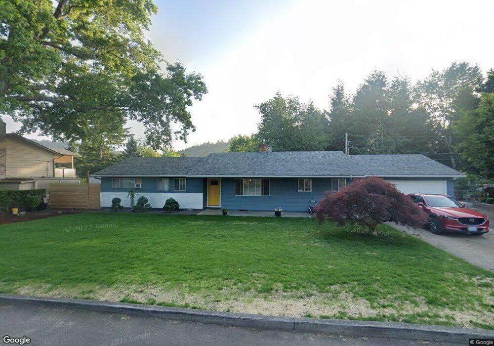
1105 SE Liberty Ave Gresham, OR 97080
Historic Southeast NeighborhoodEstimated Value: $453,000 - $466,000
3
Beds
2
Baths
1,474
Sq Ft
$313/Sq Ft
Est. Value
About This Home
This home is located at 1105 SE Liberty Ave, Gresham, OR 97080 and is currently estimated at $460,848, approximately $312 per square foot. 1105 SE Liberty Ave is a home located in Multnomah County with nearby schools including East Gresham Elementary School, Dexter McCarty Middle School, and Gresham High School.
Ownership History
Date
Name
Owned For
Owner Type
Purchase Details
Closed on
Sep 9, 2016
Sold by
Klein Jan
Bought by
Klein Dana G and Klein Sharon
Current Estimated Value
Home Financials for this Owner
Home Financials are based on the most recent Mortgage that was taken out on this home.
Original Mortgage
$225,996
Interest Rate
3.43%
Mortgage Type
Seller Take Back
Purchase Details
Closed on
Dec 4, 2015
Sold by
Klein Janet
Bought by
Klein Jan G and Klein Heidi A
Create a Home Valuation Report for This Property
The Home Valuation Report is an in-depth analysis detailing your home's value as well as a comparison with similar homes in the area
Home Values in the Area
Average Home Value in this Area
Purchase History
| Date | Buyer | Sale Price | Title Company |
|---|---|---|---|
| Klein Dana G | $225,996 | Fidelity Natl Title Of Or | |
| Klein Jan G | $205,000 | Fidelity Natl Title Co Of Or |
Source: Public Records
Mortgage History
| Date | Status | Borrower | Loan Amount |
|---|---|---|---|
| Closed | Klein Dana G | $225,996 |
Source: Public Records
Tax History
| Year | Tax Paid | Tax Assessment Tax Assessment Total Assessment is a certain percentage of the fair market value that is determined by local assessors to be the total taxable value of land and additions on the property. | Land | Improvement |
|---|---|---|---|---|
| 2025 | $4,941 | $242,800 | -- | -- |
| 2024 | $4,730 | $235,730 | -- | -- |
| 2023 | $4,730 | $228,870 | -- | -- |
| 2022 | $4,189 | $222,210 | $0 | $0 |
| 2021 | $4,083 | $215,740 | $0 | $0 |
| 2020 | $3,842 | $209,460 | $0 | $0 |
| 2019 | $3,741 | $203,360 | $0 | $0 |
| 2018 | $3,567 | $197,440 | $0 | $0 |
| 2017 | $3,423 | $191,690 | $0 | $0 |
| 2016 | $3,018 | $186,110 | $0 | $0 |
| 2015 | $2,952 | $180,690 | $0 | $0 |
| 2014 | $2,881 | $175,430 | $0 | $0 |
Source: Public Records
Map
Nearby Homes
- 1949 SE Palmquist Rd Unit 51
- 1949 SE Palmquist Rd Unit 91
- 1949 SE Palmquist Rd Unit 121
- 511 SE 15th St
- 1918 SE Regner Rd
- 2024 SE Spruce Ave
- 1715 SE 5th St Unit 1725
- 2137 SE 15th Aly
- 1414 SE Beech Place
- 450 SE Hogan Rd
- 1700 SE 4th St
- 2293 SE 15th Aly
- 732 SE Rene Ave
- 2358 SE Palmquist Rd
- 2240 SE 16th St
- 2125 SE 18th Aly
- 2392 SE 16th Aly
- 4740 SE 2nd St
- 4764 SE 2nd St
- 4667 SE 2nd St
- 1191 SE Liberty Ave
- 1095 SE Liberty Ave
- 1134 SE Liberty Ave
- 1162 SE Liberty Ave
- 1080 SE Liberty Ave
- 1195 SE Liberty Ave
- 1055 SE Liberty Ave
- 1224 SE Liberty Ave
- 1066 SE Liberty Ave
- 1129 SE Maple Place
- 1159 SE Maple Place
- 1255 SE Liberty Ave
- 1256 SE Liberty Ave
- 1025 SE Liberty Ave
- 1010 SE Liberty Ave
- 1391 SE 11th St
- 1217 SE Maple Place
- 1345 SE Liberty Ave
- 1350 SE 10th St
- 1275 SE Liberty Ave
Your Personal Tour Guide
Ask me questions while you tour the home.