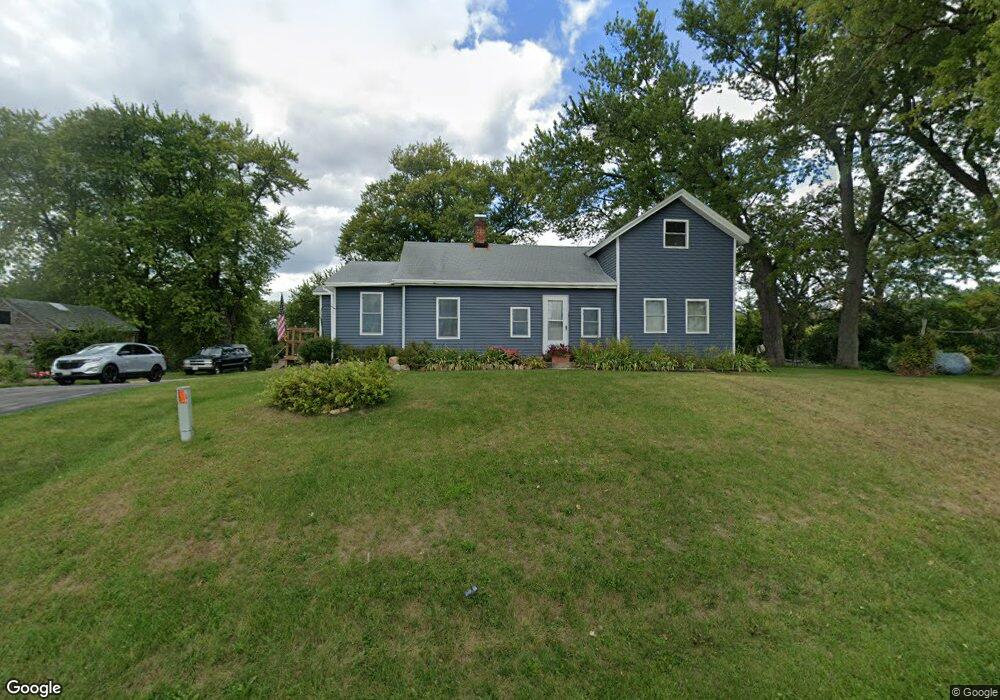
1107 Flint Rd Stoughton, WI 53589
Estimated Value: $445,048 - $576,000
--
Bed
--
Bath
--
Sq Ft
17.35
Acres
About This Home
This home is located at 1107 Flint Rd, Stoughton, WI 53589 and is currently estimated at $516,683. 1107 Flint Rd is a home located in Dane County with nearby schools including Fox Prairie Elementary School, River Bluff Middle School, and Stoughton High School.
Ownership History
Date
Name
Owned For
Owner Type
Purchase Details
Closed on
Dec 15, 2020
Sold by
Handeland Evelyn
Bought by
Handeland Janelle M and Handeland John M
Current Estimated Value
Home Financials for this Owner
Home Financials are based on the most recent Mortgage that was taken out on this home.
Original Mortgage
$160,000
Outstanding Balance
$142,448
Interest Rate
2.7%
Mortgage Type
New Conventional
Estimated Equity
$374,235
Create a Home Valuation Report for This Property
The Home Valuation Report is an in-depth analysis detailing your home's value as well as a comparison with similar homes in the area
Home Values in the Area
Average Home Value in this Area
Purchase History
| Date | Buyer | Sale Price | Title Company |
|---|---|---|---|
| Handeland Janelle M | $250,000 | None Available |
Source: Public Records
Mortgage History
| Date | Status | Borrower | Loan Amount |
|---|---|---|---|
| Open | Handeland Janelle M | $160,000 |
Source: Public Records
Tax History Compared to Growth
Tax History
| Year | Tax Paid | Tax Assessment Tax Assessment Total Assessment is a certain percentage of the fair market value that is determined by local assessors to be the total taxable value of land and additions on the property. | Land | Improvement |
|---|---|---|---|---|
| 2024 | $3,509 | $292,500 | $203,700 | $88,800 |
| 2023 | $3,023 | $292,200 | $203,400 | $88,800 |
| 2021 | $3,039 | $181,600 | $119,300 | $62,300 |
| 2020 | $2,991 | $181,700 | $119,400 | $62,300 |
| 2019 | $2,934 | $181,800 | $119,500 | $62,300 |
| 2018 | $2,958 | $181,700 | $119,400 | $62,300 |
| 2017 | $2,970 | $181,700 | $119,400 | $62,300 |
| 2016 | $2,835 | $181,900 | $119,600 | $62,300 |
| 2015 | $2,977 | $181,800 | $119,500 | $62,300 |
| 2014 | $2,839 | $181,800 | $119,500 | $62,300 |
| 2013 | $2,853 | $181,800 | $119,500 | $62,300 |
Source: Public Records
Map
Nearby Homes
- 4631 County Road A
- 562 Lexington Dr Unit 20
- +/-236 Ac Old Stone Rd
- 581 Concord Dr
- 938 Johnson Ave
- 402 Concord Dr
- LOT 97 Foxfield Ct
- LOT 103 Foxfield Ct
- 1038 Autumn Blaze Ct
- 4432 Old Stage Rd
- 1009 Autumn Blaze Ct
- 1063 Autumn Blaze Ct
- 1085 Autumn Blaze Ct
- The Birchwood Plan at Autumn Ridge
- The Mulberry Plan at Autumn Ridge
- The Lily Plan at Autumn Ridge
- The Lavender Plan at Autumn Ridge
- The Azalea Plan at Autumn Ridge
- The Holly Plan at Autumn Ridge
- The Wicklow Plan at Autumn Ridge
- L1 Flint Rd
- 1123 Flint Rd
- 1161 Flint Rd
- 1031 Flint Rd
- 1189 Flint Rd
- 1006 Flint Rd
- 1191 Flint Rd
- 1005 Flint Rd
- 1210 Sunrise Rd
- 1190 Sunrise Rd
- 1208 Sunrise Rd
- 962 Flint Rd
- 4230 Sunny Ridge Rd
- 1216 Sunrise Rd
- 4271 Oak Hill Rd
- 975 Flint Rd
- 1201 Sunrise Rd
- 1222 Sunrise Rd
- 4280 Oak Hill Rd
- 4252 Sunny Ridge Rd