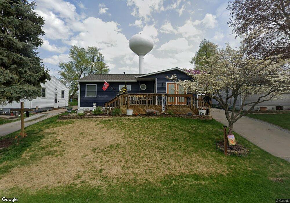
1107 Hacker St Buffalo, IA 52728
Estimated Value: $177,000 - $214,000
4
Beds
3
Baths
1,254
Sq Ft
$159/Sq Ft
Est. Value
About This Home
This home is located at 1107 Hacker St, Buffalo, IA 52728 and is currently estimated at $199,846, approximately $159 per square foot. 1107 Hacker St is a home located in Scott County with nearby schools including Liberty Elementary School, Buffalo Elementary School, and Walcott Intermediate School.
Ownership History
Date
Name
Owned For
Owner Type
Purchase Details
Closed on
Apr 15, 2021
Sold by
Thornton Christine M and Carson Jeffrey A
Bought by
Teel Steven Lowell and Teel Lynette Renee
Current Estimated Value
Home Financials for this Owner
Home Financials are based on the most recent Mortgage that was taken out on this home.
Original Mortgage
$130,000
Outstanding Balance
$107,589
Interest Rate
3%
Mortgage Type
New Conventional
Estimated Equity
$92,257
Create a Home Valuation Report for This Property
The Home Valuation Report is an in-depth analysis detailing your home's value as well as a comparison with similar homes in the area
Home Values in the Area
Average Home Value in this Area
Purchase History
| Date | Buyer | Sale Price | Title Company |
|---|---|---|---|
| Teel Steven Lowell | $150,000 | None Available |
Source: Public Records
Mortgage History
| Date | Status | Borrower | Loan Amount |
|---|---|---|---|
| Open | Teel Steven Lowell | $130,000 |
Source: Public Records
Tax History Compared to Growth
Tax History
| Year | Tax Paid | Tax Assessment Tax Assessment Total Assessment is a certain percentage of the fair market value that is determined by local assessors to be the total taxable value of land and additions on the property. | Land | Improvement |
|---|---|---|---|---|
| 2025 | $2,578 | $198,500 | $17,200 | $181,300 |
| 2024 | $2,458 | $174,800 | $17,200 | $157,600 |
| 2023 | $2,508 | $174,800 | $17,200 | $157,600 |
| 2022 | $2,458 | $142,110 | $9,720 | $132,390 |
| 2021 | $2,458 | $142,110 | $9,720 | $132,390 |
| 2020 | $2,278 | $140,210 | $9,720 | $130,490 |
| 2019 | $2,256 | $134,650 | $9,720 | $124,930 |
| 2018 | $2,204 | $134,650 | $9,720 | $124,930 |
| 2017 | $730 | $134,650 | $9,720 | $124,930 |
| 2016 | $2,010 | $126,280 | $0 | $0 |
| 2015 | $2,010 | $120,070 | $0 | $0 |
| 2014 | $1,934 | $120,070 | $0 | $0 |
| 2013 | $1,892 | $0 | $0 | $0 |
| 2012 | -- | $120,310 | $9,720 | $110,590 |
Source: Public Records
Map
Nearby Homes
- 516 4th St
- 116 Main St
- 1131 Chestnut St
- 1240 Spruce St
- 702 - 708 W Front St
- 9520 115th St
- 3 Chestnut Dr
- 11501 Devils Creek Rd
- 5 E Timberline Dr
- 61 W Timberline Dr
- 12080 100th Ave
- Lot 01 95th Ave
- Lot 02 95th Ave
- 0 5th St W
- 226 4th Ave W Unit 173
- 7 Sandpiper Dr
- 9933 123rd St
- 228 6th Ave E
- 8528 101st St W
- 13109 83rd Ave
- 1105 Hacker St
- 1109 Hacker St
- 1117 Hacker St
- 1103 Hacker St
- 1102 Hacker St
- 1206 Hacker St
- 1018 Hacker St
- 1003 Hacker St
- 1002 Hacker St
- 1208 Hacker St
- 915 Franklin St
- 913 Franklin St
- 814 Hacker St
- 1015 Franklin St
- 903 Franklin St
- 1000 Jefferson St
- 812 Hacker St
- 815 Hacker St
- 827 Franklin St
- 717 Enfield Dr