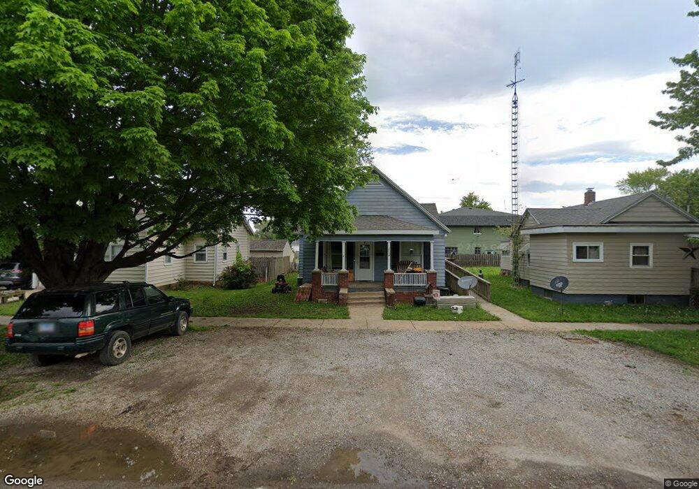
1108 Moultrie Ave Mattoon, IL 61938
Estimated Value: $59,572 - $76,000
2
Beds
1
Bath
1,006
Sq Ft
$68/Sq Ft
Est. Value
About This Home
This home is located at 1108 Moultrie Ave, Mattoon, IL 61938 and is currently estimated at $68,893, approximately $68 per square foot. 1108 Moultrie Ave is a home located in Coles County with nearby schools including Mattoon High School.
Ownership History
Date
Name
Owned For
Owner Type
Purchase Details
Closed on
Dec 19, 2017
Sold by
Washington Savings Bank
Bought by
Rescue Trust
Current Estimated Value
Purchase Details
Closed on
Apr 6, 2011
Sold by
Painted Lady Properties Inc
Bought by
First Federal Savings & Loan Assn and Land Trust 6497
Home Financials for this Owner
Home Financials are based on the most recent Mortgage that was taken out on this home.
Original Mortgage
$159,000
Interest Rate
4.93%
Mortgage Type
New Conventional
Purchase Details
Closed on
Apr 20, 2010
Sold by
Rowland James E and Butler Louis
Bought by
First Mid Illinois Bank & Trust N A
Create a Home Valuation Report for This Property
The Home Valuation Report is an in-depth analysis detailing your home's value as well as a comparison with similar homes in the area
Home Values in the Area
Average Home Value in this Area
Purchase History
| Date | Buyer | Sale Price | Title Company |
|---|---|---|---|
| Rescue Trust | -- | None Available | |
| First Federal Savings & Loan Assn | -- | None Available | |
| First Mid Illinois Bank & Trust N A | -- | None Available |
Source: Public Records
Mortgage History
| Date | Status | Borrower | Loan Amount |
|---|---|---|---|
| Previous Owner | First Federal Savings & Loan Assn | $159,000 |
Source: Public Records
Tax History Compared to Growth
Tax History
| Year | Tax Paid | Tax Assessment Tax Assessment Total Assessment is a certain percentage of the fair market value that is determined by local assessors to be the total taxable value of land and additions on the property. | Land | Improvement |
|---|---|---|---|---|
| 2024 | $503 | $11,923 | $1,243 | $10,680 |
| 2023 | $941 | $10,646 | $1,110 | $9,536 |
| 2022 | $915 | $10,470 | $1,092 | $9,378 |
| 2021 | $371 | $9,617 | $1,003 | $8,614 |
| 2020 | $361 | $9,964 | $1,039 | $8,925 |
| 2019 | $336 | $9,617 | $3,744 | $5,873 |
| 2018 | $330 | $9,617 | $3,744 | $5,873 |
| 2017 | $329 | $9,617 | $3,744 | $5,873 |
| 2016 | $322 | $9,617 | $3,744 | $5,873 |
| 2015 | $846 | $9,617 | $3,744 | $5,873 |
| 2014 | $846 | $9,617 | $3,744 | $5,873 |
| 2013 | $846 | $9,617 | $3,744 | $5,873 |
Source: Public Records
Map
Nearby Homes
- 1021 Piatt Ave
- 817 N 11th St
- 1205 Champaign Ave
- 916 Piatt Ave
- 1412 Champaign Ave
- 1101 N 10th St
- 801 Richmond Ave
- 1120 Broadway Ave
- 1120 N 11th St
- 1705 Dewitt Ave
- 1612 Richmond Ave
- 512 Dewitt Ave
- 909 Broadway Ave
- 421 Dewitt Ave
- 1816 Grant Ave
- 1905 Dewitt Ave
- 1001 Wabash Ave
- 1904 Dewitt Ave
- 1900 Champaign Ave
- 1908 Dewitt Ave
- 1112 Moultrie Ave
- 1104 Moultrie Ave
- 1100 Moultrie Ave
- 1101 Dewitt Ave
- 1113 Dewitt Ave
- 1121 Dewitt Ave
- 1109 Moultrie Ave
- 1101 Moultrie Ave
- 1020 Moultrie Ave
- 1113 Moultrie Ave
- 1105 Dewitt Ave Unit 1101
- 520 N 12th St
- 1016 Moultrie Ave
- 1201 Dewitt Ave
- 1021 Moultrie Ave
- 1021 Dewitt Ave
- 1012 Moultrie Ave
- 1201 Moultrie Ave
- 1100 Dewitt Ave
- 1017 Moultrie Ave