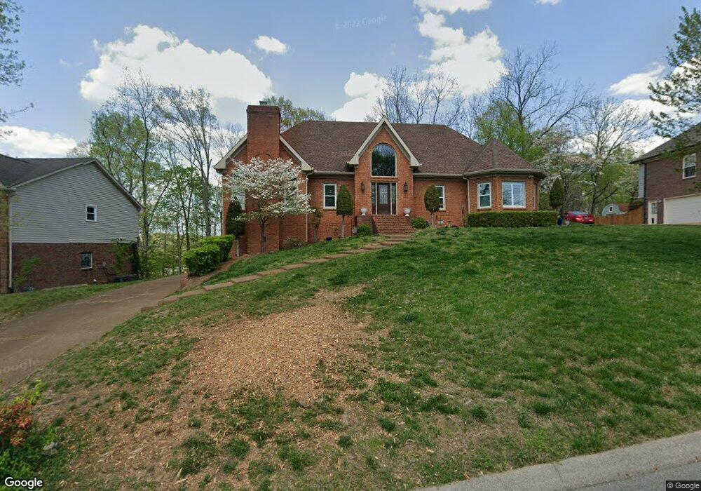
1109 Brookstone Blvd Mount Juliet, TN 37122
Estimated Value: $518,062 - $587,000
--
Bed
3
Baths
3,349
Sq Ft
$167/Sq Ft
Est. Value
About This Home
This home is located at 1109 Brookstone Blvd, Mount Juliet, TN 37122 and is currently estimated at $559,766, approximately $167 per square foot. 1109 Brookstone Blvd is a home located in Wilson County with nearby schools including Mt. Juliet Elementary School, Mt. Juliet Middle School, and Green Hill High School.
Ownership History
Date
Name
Owned For
Owner Type
Purchase Details
Closed on
Nov 30, 1995
Bought by
Holloway Ronald E
Current Estimated Value
Purchase Details
Closed on
Oct 8, 1992
Bought by
Hardick Robert E
Purchase Details
Closed on
Feb 28, 1991
Bought by
Kyle Donnie K
Purchase Details
Closed on
Apr 28, 1989
Bought by
Batson Carl Stephen and Deborah Jo
Purchase Details
Closed on
Apr 4, 1904
Bought by
Brookstone Limited Two Brentwood Commons
Create a Home Valuation Report for This Property
The Home Valuation Report is an in-depth analysis detailing your home's value as well as a comparison with similar homes in the area
Home Values in the Area
Average Home Value in this Area
Purchase History
| Date | Buyer | Sale Price | Title Company |
|---|---|---|---|
| Holloway Ronald E | $185,000 | -- | |
| Hardick Robert E | $157,000 | -- | |
| Kyle Donnie K | $152,000 | -- | |
| Batson Carl Stephen | $25,500 | -- | |
| Brookstone Limited Two Brentwood Commons | -- | -- |
Source: Public Records
Tax History Compared to Growth
Tax History
| Year | Tax Paid | Tax Assessment Tax Assessment Total Assessment is a certain percentage of the fair market value that is determined by local assessors to be the total taxable value of land and additions on the property. | Land | Improvement |
|---|---|---|---|---|
| 2024 | $1,783 | $93,400 | $21,250 | $72,150 |
| 2022 | $1,783 | $93,400 | $21,250 | $72,150 |
| 2021 | $1,886 | $93,400 | $21,250 | $72,150 |
| 2020 | $1,818 | $93,400 | $21,250 | $72,150 |
| 2019 | $224 | $67,675 | $18,750 | $48,925 |
| 2018 | $1,809 | $67,375 | $18,750 | $48,625 |
| 2017 | $1,809 | $67,375 | $18,750 | $48,625 |
| 2016 | $1,809 | $67,375 | $18,750 | $48,625 |
| 2015 | $1,867 | $67,375 | $18,750 | $48,625 |
| 2014 | $1,630 | $58,847 | $0 | $0 |
Source: Public Records
Map
Nearby Homes
- 1120 Brookstone Blvd
- 288 Page Dr
- 1013 Brookstone Blvd
- 1520 Brookstone Cir
- 271 Page Dr
- 493 Page Dr
- 1105 Camden Cir
- 222 Jackson Trail
- 212 Jackson Trail
- 506 Page Dr
- 144 W Division St
- 3107 Oxford Dr
- 2001 Lynnhaven Ct
- 2202 Dinah Ct
- 700 Castle Rd
- 4014 Ethan Ave
- 2006 Lynnhaven Ct
- 604 Georgian Way
- 3890 W Division St
- 1733 Hartford Ln
- 1111 Brookstone Blvd
- 1107 Brookstone Blvd
- 1113 Brookstone Blvd
- 1110 Brookstone Blvd
- 1105 Brookstone Blvd
- 1604 Brookvalley Cir
- 1108 Brookstone Blvd
- 1112 Brookstone Blvd
- 1606 Brookvalley Cir
- 1602 Brookvalley Cir
- 1106 Brookstone Blvd
- 1303 Thoreau Ct
- 1206 Walden Place
- 1802 Brookvalley Place
- 1114 Brookstone Blvd
- 1101 Brookstone Blvd
- 1800 Brookvalley Place
- 1115 Brookstone Blvd
- 1102 Brookstone Blvd
- 2107 Thoreau Place