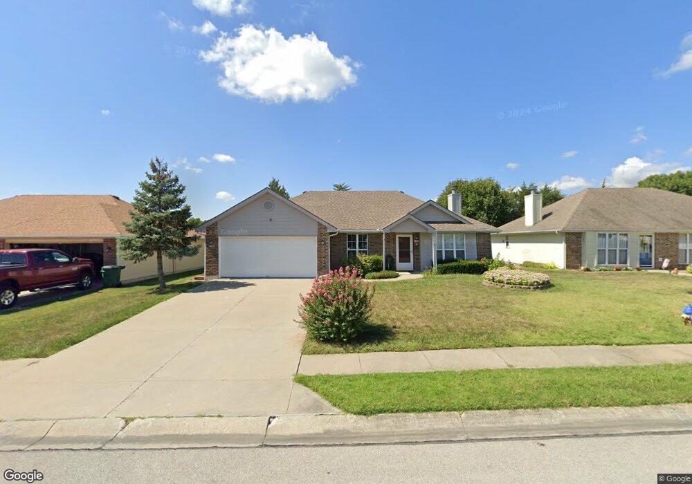
1109 Foxridge Dr Warrensburg, MO 64093
Estimated Value: $202,471 - $250,000
--
Bed
--
Bath
1,554
Sq Ft
$151/Sq Ft
Est. Value
About This Home
This home is located at 1109 Foxridge Dr, Warrensburg, MO 64093 and is currently estimated at $234,618, approximately $150 per square foot. 1109 Foxridge Dr is a home located in Johnson County with nearby schools including Ridge View Elementary School, Sterling Elementary School, and Warrensburg Middle School.
Ownership History
Date
Name
Owned For
Owner Type
Purchase Details
Closed on
Jan 3, 2020
Sold by
Vinardi Gregory B and James A Constance V Weikel Tru
Bought by
Snipes Troy D and Snipes Leolanda A
Current Estimated Value
Home Financials for this Owner
Home Financials are based on the most recent Mortgage that was taken out on this home.
Original Mortgage
$101,250
Outstanding Balance
$89,458
Interest Rate
3.6%
Mortgage Type
New Conventional
Estimated Equity
$145,160
Purchase Details
Closed on
Apr 28, 2008
Sold by
Weikel James A and Weikel Constance V
Bought by
Weikel James A and Weikel Constance
Create a Home Valuation Report for This Property
The Home Valuation Report is an in-depth analysis detailing your home's value as well as a comparison with similar homes in the area
Home Values in the Area
Average Home Value in this Area
Purchase History
| Date | Buyer | Sale Price | Title Company |
|---|---|---|---|
| Snipes Troy D | -- | Truman Title Inc | |
| Weikel James A | -- | -- |
Source: Public Records
Mortgage History
| Date | Status | Borrower | Loan Amount |
|---|---|---|---|
| Open | Snipes Troy D | $101,250 |
Source: Public Records
Tax History Compared to Growth
Tax History
| Year | Tax Paid | Tax Assessment Tax Assessment Total Assessment is a certain percentage of the fair market value that is determined by local assessors to be the total taxable value of land and additions on the property. | Land | Improvement |
|---|---|---|---|---|
| 2024 | $1,395 | $18,273 | $0 | $0 |
| 2023 | $1,395 | $18,273 | $0 | $0 |
| 2022 | $1,345 | $17,534 | $0 | $0 |
| 2021 | $1,340 | $17,534 | $0 | $0 |
| 2020 | $1,298 | $16,793 | $0 | $0 |
| 2019 | $1,297 | $16,793 | $0 | $0 |
| 2017 | $1,294 | $16,793 | $0 | $0 |
| 2016 | $1,192 | $16,793 | $0 | $0 |
| 2015 | $1,224 | $16,793 | $0 | $0 |
| 2014 | -- | $16,793 | $0 | $0 |
Source: Public Records
Map
Nearby Homes
- 1002 Weschester Ct
- 1509 Coventry Ct
- 1507 Coventry Ct
- 1505 Coventry Ct
- 1503 Coventry Ct
- 1510 Coventry Ct
- 1506 Coventry Ct
- 1508 Coventry Ct
- 1406 Grandview Dr
- 1421 Grandview Dr
- 1410 Grandview Dr
- 135 Cedar Ct
- 134 Cedar Ct
- 1090 Pebblecreek Dr
- 1092 Pebblecreek Dr
- 1094 Pebblecreek Dr
- 1096 Pebblecreek Dr
- 1098 Pebblecreek Dr
- 1504 Park Ave
- 1411 Woodlawn Dr
- 1107 Foxridge Dr
- 1111 Foxridge Dr
- 1105 Foxridge Dr
- 1113 Foxridge Dr
- 1110 Foxridge Dr
- 1112 Foxridge Dr
- 1108 Foxridge Dr
- 1201 Foxridge Dr
- 1103 Foxridge Dr
- 1106 Foxridge Dr
- 1002 Hampton Dr
- 1203 Foxridge Dr
- 1202 Foxridge Dr
- 1101 Foxridge Dr
- 1104 Foxridge Dr
- 1001 Weschester Ct
- 1003 Weschester Ct
- 1006 Pca Rd
- 1000 Pca Rd
- 1004 Hampton Dr