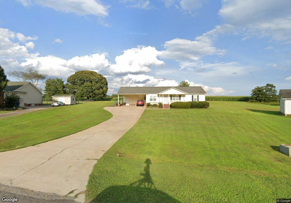
111 Elmarg Dr Kings Mountain, NC 28086
Estimated Value: $252,201 - $295,000
3
Beds
2
Baths
1,268
Sq Ft
$218/Sq Ft
Est. Value
About This Home
This home is located at 111 Elmarg Dr, Kings Mountain, NC 28086 and is currently estimated at $275,800, approximately $217 per square foot. 111 Elmarg Dr is a home located in Cleveland County with nearby schools including Bethware Elementary School, Kings Mountain Middle, and Kings Mountain Intermediate School.
Ownership History
Date
Name
Owned For
Owner Type
Purchase Details
Closed on
Jun 25, 2009
Sold by
Dunn Thomas A
Bought by
Babb Kenneth W
Current Estimated Value
Home Financials for this Owner
Home Financials are based on the most recent Mortgage that was taken out on this home.
Original Mortgage
$121,380
Outstanding Balance
$77,101
Interest Rate
4.79%
Mortgage Type
Purchase Money Mortgage
Estimated Equity
$198,699
Purchase Details
Closed on
Aug 31, 2007
Sold by
Dunn Mary Beth
Bought by
Dunn Thomas A
Create a Home Valuation Report for This Property
The Home Valuation Report is an in-depth analysis detailing your home's value as well as a comparison with similar homes in the area
Home Values in the Area
Average Home Value in this Area
Purchase History
| Date | Buyer | Sale Price | Title Company |
|---|---|---|---|
| Babb Kenneth W | $119,000 | None Available | |
| Dunn Thomas A | -- | None Available |
Source: Public Records
Mortgage History
| Date | Status | Borrower | Loan Amount |
|---|---|---|---|
| Open | Babb Kenneth W | $121,380 |
Source: Public Records
Tax History Compared to Growth
Tax History
| Year | Tax Paid | Tax Assessment Tax Assessment Total Assessment is a certain percentage of the fair market value that is determined by local assessors to be the total taxable value of land and additions on the property. | Land | Improvement |
|---|---|---|---|---|
| 2025 | $1,388 | $218,554 | $23,360 | $195,194 |
| 2024 | $1,234 | $145,165 | $23,360 | $121,805 |
| 2023 | $1,228 | $145,165 | $23,360 | $121,805 |
| 2022 | $1,228 | $145,165 | $23,360 | $121,805 |
| 2021 | $1,232 | $145,165 | $23,360 | $121,805 |
| 2020 | $996 | $111,479 | $19,996 | $91,483 |
| 2019 | $996 | $111,479 | $19,996 | $91,483 |
| 2018 | $992 | $111,479 | $19,996 | $91,483 |
| 2017 | $987 | $111,479 | $19,996 | $91,483 |
| 2016 | $943 | $111,479 | $19,996 | $91,483 |
| 2015 | $970 | $114,893 | $18,688 | $96,205 |
| 2014 | $970 | $114,893 | $18,688 | $96,205 |
Source: Public Records
Map
Nearby Homes
- 608 Rollingbrook Rd
- 124 Rollingbrook Rd
- 000 Putnam Lake Rd
- 101 Long Meadows Dr
- 106 Kelly Marie
- 105 Gold Run Ct
- 123 Gold Run Ct
- 221 Reliance Rd
- 100 Tripp Dr
- 104 Ole Farm Place
- 167 Patterson Rd
- 1427 Merrimont Ave
- 155 Patterson Rd
- 236 Hoyles Rd
- 215 J Robinson Pkwy
- 104 Edison St
- 213 Press Sweezy Rd
- 521 Coman Ln
- 1417 Merrimont Ave
- 117 Dutchess Dr