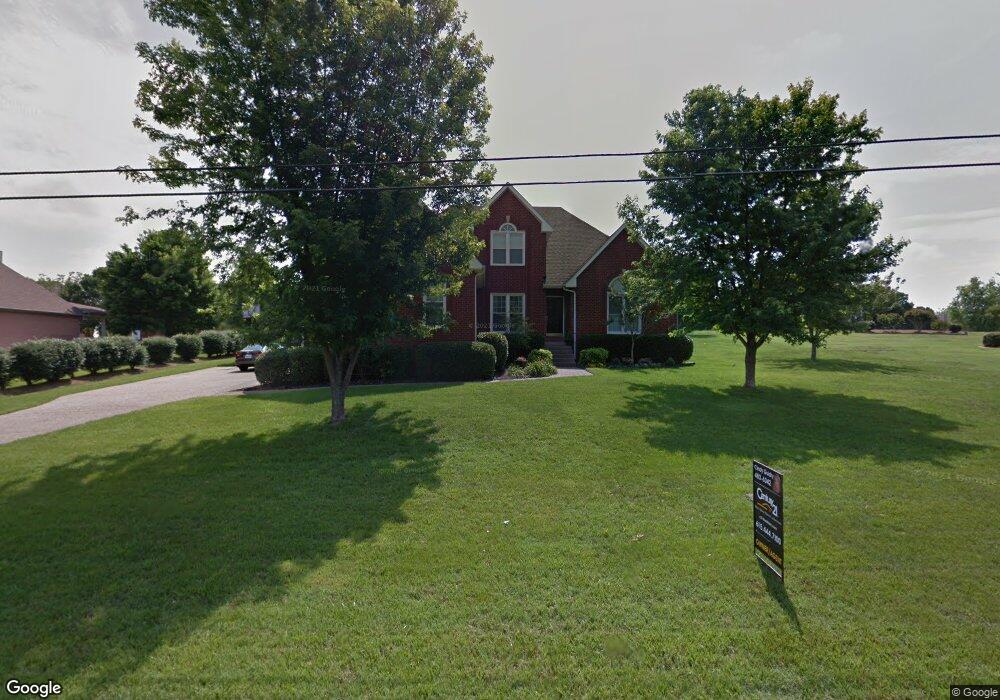
111 Jarod Way Lebanon, TN 37087
Estimated Value: $572,860 - $684,000
3
Beds
3
Baths
3,100
Sq Ft
$210/Sq Ft
Est. Value
About This Home
This home is located at 111 Jarod Way, Lebanon, TN 37087 and is currently estimated at $650,715, approximately $209 per square foot. 111 Jarod Way is a home located in Wilson County with nearby schools including Castle Heights Elementary School, Winfree Bryant Middle School, and Lebanon High School.
Ownership History
Date
Name
Owned For
Owner Type
Purchase Details
Closed on
Jun 7, 2001
Bought by
Guidry Dennis J and Guidry Cynthia S
Current Estimated Value
Home Financials for this Owner
Home Financials are based on the most recent Mortgage that was taken out on this home.
Original Mortgage
$197,600
Outstanding Balance
$74,830
Interest Rate
7.06%
Estimated Equity
$575,885
Purchase Details
Closed on
Jan 18, 2000
Sold by
Brown Mark T
Bought by
Hubbard John L
Create a Home Valuation Report for This Property
The Home Valuation Report is an in-depth analysis detailing your home's value as well as a comparison with similar homes in the area
Home Values in the Area
Average Home Value in this Area
Purchase History
| Date | Buyer | Sale Price | Title Company |
|---|---|---|---|
| Guidry Dennis J | $247,000 | -- | |
| Hubbard John L | $201,000 | -- |
Source: Public Records
Mortgage History
| Date | Status | Borrower | Loan Amount |
|---|---|---|---|
| Open | Hubbard John L | $197,600 |
Source: Public Records
Tax History Compared to Growth
Tax History
| Year | Tax Paid | Tax Assessment Tax Assessment Total Assessment is a certain percentage of the fair market value that is determined by local assessors to be the total taxable value of land and additions on the property. | Land | Improvement |
|---|---|---|---|---|
| 2024 | $2,035 | $92,250 | $16,250 | $76,000 |
| 2022 | $2,667 | $92,250 | $16,250 | $76,000 |
| 2021 | $2,668 | $92,250 | $16,250 | $76,000 |
| 2020 | $2,771 | $92,250 | $16,250 | $76,000 |
| 2019 | $632 | $73,725 | $12,025 | $61,700 |
| 2018 | $2,587 | $73,725 | $12,025 | $61,700 |
| 2017 | $2,587 | $73,725 | $12,025 | $61,700 |
| 2016 | $2,587 | $73,725 | $12,025 | $61,700 |
| 2015 | $2,675 | $73,725 | $12,025 | $61,700 |
| 2014 | $2,390 | $65,891 | $0 | $0 |
Source: Public Records
Map
Nearby Homes
- 108 Southfork Dr
- 2019 Arlington Rd
- 0 Palmer Rd
- 1930 Arlington Rd
- 0 Horn Springs Rd Unit RTC2822266
- 0 Horn Springs Rd Unit RTC2822257
- 0 Horn Springs Rd Unit RTC2780684
- 523 Medwyk Dr
- 1920 Hampton Dr
- 3 Horn Springs Rd
- The Peachtree Plan at Stratford Station
- The James Plan at Stratford Station
- The Harrington Plan at Stratford Station
- The Braselton II Plan at Stratford Station
- The Palmer Plan at Stratford Station
- The Telfair Plan at Stratford Station
- The Langford Plan at Stratford Station
- The McGinnis Plan at Stratford Station
- 119 Fister Dr
- 1063 River Oaks Blvd
- 2101 Ewing Dr
- 109 Jarod Way
- 108 Lexington Dr
- 110 Jarod Way
- 106 Lexington Dr
- 110 Lexington Dr
- 112 Jarod Way
- 108 Jarod Way
- 107 Jarod Way
- 104 Lexington Dr
- 201 Jarod Way
- 106 Jarod Way
- 109 Lexington Dr
- 202 Lexington Dr
- 111 Lexington Dr
- 2201 Ewing Dr
- 107 Lexington Dr
- 200 Jarod Way
- 105 Jarod Way
- 201 Lexington Dr