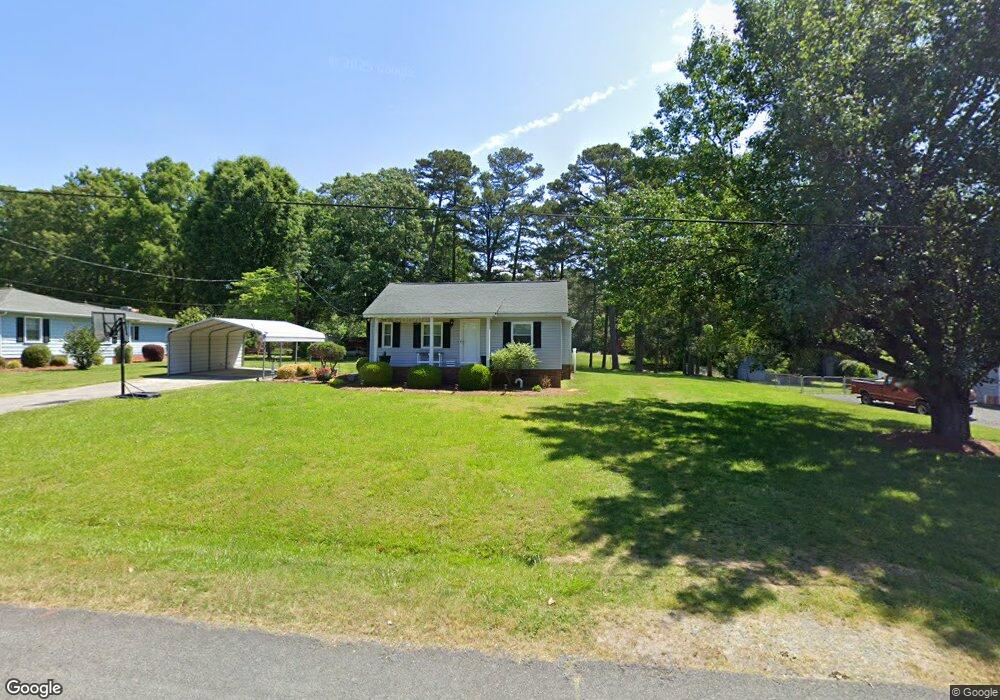
111 Simpson Rd Locust, NC 28097
Estimated Value: $282,728 - $335,000
3
Beds
2
Baths
1,400
Sq Ft
$215/Sq Ft
Est. Value
About This Home
This home is located at 111 Simpson Rd, Locust, NC 28097 and is currently estimated at $300,932, approximately $214 per square foot. 111 Simpson Rd is a home located in Stanly County with nearby schools including Locust Elementary School, West Stanly Middle School, and West Stanly High School.
Ownership History
Date
Name
Owned For
Owner Type
Purchase Details
Closed on
Feb 20, 2013
Sold by
Weeks Patricia M and Miller James Brent
Bought by
Almond Phil Everette and Almond Janet M
Current Estimated Value
Home Financials for this Owner
Home Financials are based on the most recent Mortgage that was taken out on this home.
Original Mortgage
$62,000
Interest Rate
3.43%
Mortgage Type
Unknown
Create a Home Valuation Report for This Property
The Home Valuation Report is an in-depth analysis detailing your home's value as well as a comparison with similar homes in the area
Home Values in the Area
Average Home Value in this Area
Purchase History
| Date | Buyer | Sale Price | Title Company |
|---|---|---|---|
| Almond Phil Everette | $60,000 | None Available |
Source: Public Records
Mortgage History
| Date | Status | Borrower | Loan Amount |
|---|---|---|---|
| Closed | Almond Phil Everette | $62,000 |
Source: Public Records
Tax History
| Year | Tax Paid | Tax Assessment Tax Assessment Total Assessment is a certain percentage of the fair market value that is determined by local assessors to be the total taxable value of land and additions on the property. | Land | Improvement |
|---|---|---|---|---|
| 2025 | $1,705 | $185,323 | $49,593 | $135,730 |
| 2024 | $1,304 | $119,644 | $29,305 | $90,339 |
| 2023 | $1,424 | $119,644 | $29,305 | $90,339 |
| 2022 | $1,412 | $119,644 | $29,305 | $90,339 |
| 2021 | $1,400 | $119,644 | $29,305 | $90,339 |
| 2020 | $1,207 | $97,264 | $25,698 | $71,566 |
| 2019 | $281 | $97,264 | $25,698 | $71,566 |
| 2018 | $1,099 | $97,264 | $25,698 | $71,566 |
| 2017 | $1,099 | $97,264 | $25,698 | $71,566 |
| 2016 | $1,082 | $95,783 | $23,895 | $71,888 |
| 2015 | $1,199 | $95,783 | $23,895 | $71,888 |
| 2014 | $1,108 | $95,783 | $23,895 | $71,888 |
Source: Public Records
Map
Nearby Homes
- 211 Drive Inn Rd
- 169 Abigail Ln
- 402 Church St
- TBD Simpson Rd
- 240 Ella Dr
- Lot 1 Meadow Creek Church Rd Unit 1
- 417 Kiser Ln
- 202 Jenkins St
- 206 Montclair Dr
- 716 Saddlebred Ln
- 744 Saddlebred Ln
- 421 Carolina Hemlock Dr
- 207 Kerri Dawn Ln
- 617 Ardsley Dr
- 306 Old Hickory Rd
- 219 Kerri Dawn Ln
- 107 Oakgrove St
- 288 Harrison Ln
- 27 Berea Baptist Church Rd
- 103 Berea Baptist Church Rd
- 109 Simpson Rd
- 113 Simpson Rd
- 107 Simpson Rd
- 115 Simpson Rd
- 112 Simpson Rd
- 114 Simpson Rd
- 108 Simpson Rd
- 105 Simpson Rd
- 106 Simpson Rd
- 118 Simpson Rd
- 120 Simpson Rd
- 103 Simpson Rd
- 203 Simpson Rd
- 105 A Kluttz St
- 107 Kluttz St
- 208 Simpson Rd
- 105 Kluttz St
- 903 Main St W
- 105 Morningstar Dr
- 109 Kluttz St
Your Personal Tour Guide
Ask me questions while you tour the home.