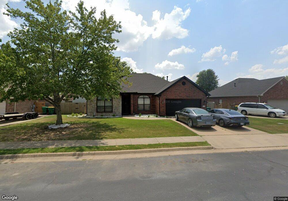
111 Skinner St Centerton, AR 72719
Estimated Value: $347,301 - $400,000
4
Beds
2
Baths
1,928
Sq Ft
$197/Sq Ft
Est. Value
About This Home
This home is located at 111 Skinner St, Centerton, AR 72719 and is currently estimated at $379,325, approximately $196 per square foot. 111 Skinner St is a home located in Benton County with nearby schools including Centerton Gamble Elementary School, Grimsley Junior High School, and Creekside Middle School.
Ownership History
Date
Name
Owned For
Owner Type
Purchase Details
Closed on
May 31, 2018
Sold by
Williams Hannah and Williams Jonathan
Bought by
Sandoval Michael
Current Estimated Value
Home Financials for this Owner
Home Financials are based on the most recent Mortgage that was taken out on this home.
Original Mortgage
$165,242
Outstanding Balance
$142,993
Interest Rate
4.62%
Mortgage Type
FHA
Estimated Equity
$236,332
Purchase Details
Closed on
Sep 22, 2009
Sold by
Haas Kurt William and Haas Courtney Brooke
Bought by
Williams Hannah
Home Financials for this Owner
Home Financials are based on the most recent Mortgage that was taken out on this home.
Original Mortgage
$161,986
Interest Rate
5.16%
Mortgage Type
FHA
Purchase Details
Closed on
Jul 21, 2004
Bought by
Haas
Purchase Details
Closed on
Jul 19, 2004
Bought by
Haas
Purchase Details
Closed on
Nov 26, 2003
Bought by
N and A
Purchase Details
Closed on
Aug 11, 2003
Bought by
Layne 12P
Create a Home Valuation Report for This Property
The Home Valuation Report is an in-depth analysis detailing your home's value as well as a comparison with similar homes in the area
Home Values in the Area
Average Home Value in this Area
Purchase History
| Date | Buyer | Sale Price | Title Company |
|---|---|---|---|
| Sandoval Michael | $199,900 | Lenders Title Company | |
| Williams Hannah | $165,000 | Clear Title Of Arkansas Llc | |
| Haas | $173,000 | -- | |
| Haas | $173,000 | -- | |
| N | -- | -- | |
| Layne 12P | -- | -- |
Source: Public Records
Mortgage History
| Date | Status | Borrower | Loan Amount |
|---|---|---|---|
| Open | Sandoval Michael | $165,242 | |
| Previous Owner | Williams Hannah | $161,986 |
Source: Public Records
Tax History
| Year | Tax Paid | Tax Assessment Tax Assessment Total Assessment is a certain percentage of the fair market value that is determined by local assessors to be the total taxable value of land and additions on the property. | Land | Improvement |
|---|---|---|---|---|
| 2025 | $2,939 | $60,931 | $15,000 | $45,931 |
| 2024 | $2,721 | $60,931 | $15,000 | $45,931 |
| 2023 | $2,474 | $40,110 | $7,600 | $32,510 |
| 2022 | $2,331 | $40,110 | $7,600 | $32,510 |
| 2021 | $1,735 | $40,110 | $7,600 | $32,510 |
| 2020 | $1,665 | $32,070 | $4,000 | $28,070 |
| 2019 | $1,665 | $32,070 | $4,000 | $28,070 |
| 2018 | $1,690 | $32,070 | $4,000 | $28,070 |
| 2017 | $1,690 | $32,070 | $4,000 | $28,070 |
| 2016 | $1,619 | $32,070 | $4,000 | $28,070 |
| 2015 | $1,934 | $31,350 | $4,000 | $27,350 |
| 2014 | $1,584 | $31,350 | $4,000 | $27,350 |
Source: Public Records
Map
Nearby Homes
- 116 Birch St
- 801 Pinoak St
- 133 Fox Run Cir
- 201 Cisterna Dr
- 961 Harvest St
- 971 Harvest St
- 2041 Tallgrass Terrace
- 571 Stoneseed St
- 2131 Periwinkle Place
- 471 Stoneseed St
- 561 Stoneseed St
- 1110 Montieri Dr
- 1041 Harvest St
- Single Family Portfo Group 5
- Single Family Portfo Group 4
- 101 Fox Run Cir
- 1161 Montieri Dr
- 1211 Longbourn Dr
- Single Family Portfo
- 741 Venice St
Your Personal Tour Guide
Ask me questions while you tour the home.