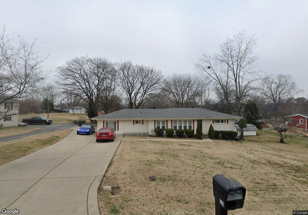
1110 Earls St Gallatin, TN 37066
Estimated Value: $296,000 - $354,000
--
Bed
2
Baths
1,580
Sq Ft
$206/Sq Ft
Est. Value
About This Home
This home is located at 1110 Earls St, Gallatin, TN 37066 and is currently estimated at $324,970, approximately $205 per square foot. 1110 Earls St is a home located in Sumner County with nearby schools including Guild Elementary School, Rucker Stewart Middle School, and Gallatin Senior High School.
Ownership History
Date
Name
Owned For
Owner Type
Purchase Details
Closed on
Dec 7, 2007
Sold by
Dobbs Michael D and Dobbs Patricia B
Bought by
Alston Jackie J and Alston Lisa
Current Estimated Value
Home Financials for this Owner
Home Financials are based on the most recent Mortgage that was taken out on this home.
Original Mortgage
$143,010
Outstanding Balance
$90,473
Interest Rate
6.29%
Mortgage Type
VA
Estimated Equity
$234,497
Purchase Details
Closed on
Nov 18, 2003
Sold by
Dobbs Patricia B
Bought by
Dobbs Michael D and Dobbs Patricia B
Home Financials for this Owner
Home Financials are based on the most recent Mortgage that was taken out on this home.
Original Mortgage
$98,000
Interest Rate
6.04%
Mortgage Type
Purchase Money Mortgage
Purchase Details
Closed on
Jan 2, 1998
Sold by
Dobbs Michael D
Bought by
Dobbs Patricia B
Purchase Details
Closed on
Mar 29, 1994
Sold by
Walker James P
Bought by
Dobbs Michael D
Create a Home Valuation Report for This Property
The Home Valuation Report is an in-depth analysis detailing your home's value as well as a comparison with similar homes in the area
Home Values in the Area
Average Home Value in this Area
Purchase History
| Date | Buyer | Sale Price | Title Company |
|---|---|---|---|
| Alston Jackie J | $140,000 | Cumberland Title | |
| Dobbs Michael D | -- | Cumberland Title Co | |
| Dobbs Patricia B | -- | -- | |
| Dobbs Michael D | $63,000 | -- |
Source: Public Records
Mortgage History
| Date | Status | Borrower | Loan Amount |
|---|---|---|---|
| Open | Alston Jackie J | $143,010 | |
| Previous Owner | Dobbs Michael D | $98,000 |
Source: Public Records
Tax History Compared to Growth
Tax History
| Year | Tax Paid | Tax Assessment Tax Assessment Total Assessment is a certain percentage of the fair market value that is determined by local assessors to be the total taxable value of land and additions on the property. | Land | Improvement |
|---|---|---|---|---|
| 2024 | $1,034 | $72,750 | $17,500 | $55,250 |
| 2023 | $1,040 | $34,075 | $8,750 | $25,325 |
| 2022 | $1,044 | $34,075 | $8,750 | $25,325 |
| 2021 | $1,044 | $34,075 | $8,750 | $25,325 |
| 2020 | $1,044 | $34,075 | $8,750 | $25,325 |
| 2019 | $1,044 | $0 | $0 | $0 |
| 2018 | $780 | $0 | $0 | $0 |
| 2017 | $780 | $0 | $0 | $0 |
| 2016 | $559 | $0 | $0 | $0 |
| 2015 | $780 | $0 | $0 | $0 |
| 2014 | $751 | $0 | $0 | $0 |
Source: Public Records
Map
Nearby Homes
- 126 Glenn Ave
- 124 Glenn Ave
- 211 Juanita Ave
- 227 Hale Ave
- 155 Hale Ave
- 919 Johnson St
- 113 Primrose Ln
- 200 Malvin St
- 119 Coles Ferry Rd
- 184 Primrose Ln
- 403 W Hite St
- 393 Ryan Ave
- 190 W Hite St
- 108 Ripplemead Ct
- 418 Malvin St
- 216 Daleview Ave
- 490 Ryan Ave
- 446 Malvin St
- 1008 Bales St
- 1340 Crescent Ridge Dr