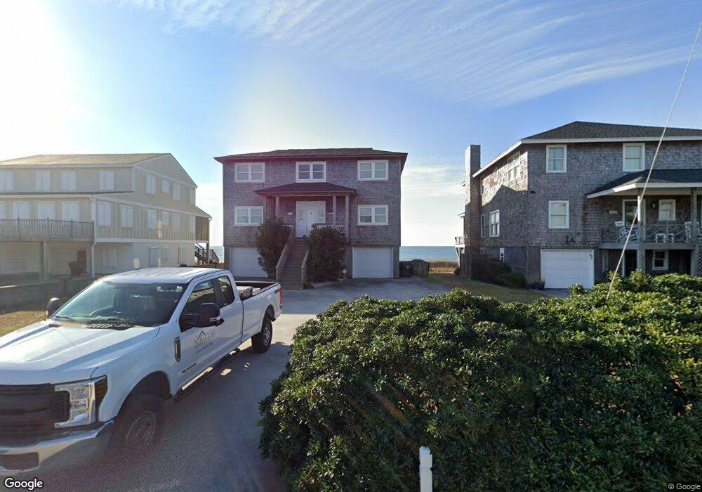
1111 Ocean Ridge Dr Atlantic Beach, NC 28512
Estimated Value: $1,591,000 - $3,013,000
5
Beds
4
Baths
2,560
Sq Ft
$903/Sq Ft
Est. Value
About This Home
This home is located at 1111 Ocean Ridge Dr, Atlantic Beach, NC 28512 and is currently estimated at $2,311,119, approximately $902 per square foot. 1111 Ocean Ridge Dr is a home located in Carteret County with nearby schools including Morehead City Primary School, Morehead Elementary School at Camp Glenn, and Morehead City Middle School.
Ownership History
Date
Name
Owned For
Owner Type
Purchase Details
Closed on
May 28, 2019
Sold by
Johnson Waddell Jane and Johnson Charles Marion
Bought by
1111 Ocean Ridge Drive Llc
Current Estimated Value
Purchase Details
Closed on
Dec 19, 2012
Sold by
Johnson Charles M
Bought by
Waddell Jane J and Johnson Charles Marion
Create a Home Valuation Report for This Property
The Home Valuation Report is an in-depth analysis detailing your home's value as well as a comparison with similar homes in the area
Home Values in the Area
Average Home Value in this Area
Purchase History
| Date | Buyer | Sale Price | Title Company |
|---|---|---|---|
| 1111 Ocean Ridge Drive Llc | -- | None Available | |
| Johnson Waddell Jane | -- | None Available | |
| Waddell Jane J | -- | None Available |
Source: Public Records
Tax History Compared to Growth
Tax History
| Year | Tax Paid | Tax Assessment Tax Assessment Total Assessment is a certain percentage of the fair market value that is determined by local assessors to be the total taxable value of land and additions on the property. | Land | Improvement |
|---|---|---|---|---|
| 2025 | $5,536 | $2,416,919 | $1,463,895 | $953,024 |
| 2024 | $5,115 | $1,475,472 | $1,238,760 | $236,712 |
| 2023 | $5,032 | $1,475,472 | $1,238,760 | $236,712 |
| 2022 | $4,884 | $1,475,472 | $1,238,760 | $236,712 |
| 2021 | $2,951 | $1,475,472 | $1,238,760 | $236,712 |
| 2020 | $4,884 | $1,475,472 | $1,238,760 | $236,712 |
| 2019 | $4,522 | $1,453,760 | $1,198,800 | $254,960 |
| 2017 | $4,522 | $1,453,760 | $1,198,800 | $254,960 |
| 2016 | $4,522 | $1,453,760 | $1,198,800 | $254,960 |
| 2015 | $4,376 | $1,453,760 | $1,198,800 | $254,960 |
| 2014 | $4,221 | $1,401,925 | $1,110,037 | $291,888 |
Source: Public Records
Map
Nearby Homes
- 123 & 125 Coral Bay Ct
- 413 W Fort MacOn Rd
- 2111 W Ft MacOn Rd Unit 251
- 221 Sound Side Dr
- 101 Bay Ridge Dr
- 113 Hoop Pole Creek Dr
- 108 Talford Dr
- 2305 W Fort MacOn Rd Unit 207
- 2306 W Ft MacOn Rd W Unit 308 H
- 2401 W Ft MacOn Rd Unit 220 Ocean Sands
- 145 Hoop Pole Creek Dr Unit B
- 2511 W Fort MacOn Rd Unit B310
- 2509 W Ft MacOn Rd W Unit 105 B
- 201 Hoop Pole Creek Dr
- 112 Lee Dr Unit A
- 2503 W Fort MacOn Rd Unit 108a
- 105 Beachwood Dr Unit 1C
- 107 Beachwood Dr Unit A2
- 107 Shady Ln
- 108 Pelican Dr Unit B
- 1109 Ocean Ridge Dr
- 1113 Ocean Ridge Dr
- 1107 Ocean Ridge Dr
- 1115 Ocean Ridge Dr
- 1105 Ocean Ridge Dr
- 1112 Ocean Ridge Dr
- 1110 Ocean Ridge Dr
- 1117 Ocean Ridge Dr
- 1103 Ocean Ridge Dr
- 1106 Ocean Ridge Dr
- 1101 Ocean Ridge Dr
- 1709 W Fort MacOn Rd
- 1104 Ocean Ridge Rd
- 1104 Ocean Ridge Rd Unit 461
- 1102 Ocean Ridge Dr
- 1015 Ocean Ridge Dr
- 2208 W Fort MacOn Rd Unit D14 Southwinds
- 1713 W Fort MacOn Rd
- 1607 W Fort MacOn Rd
- 101 Ocean Ridge Ct