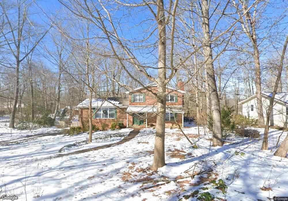
1112 Crown Point Rd W Unit 1 Signal Mountain, TN 37377
Estimated Value: $571,000 - $690,000
--
Bed
--
Bath
2,997
Sq Ft
$211/Sq Ft
Est. Value
About This Home
This home is located at 1112 Crown Point Rd W Unit 1, Signal Mountain, TN 37377 and is currently estimated at $631,882, approximately $210 per square foot. 1112 Crown Point Rd W Unit 1 is a home located in Hamilton County with nearby schools including Thrasher Elementary School, Signal Mountain Middle/High School, and Signal Mountain Christian School.
Ownership History
Date
Name
Owned For
Owner Type
Purchase Details
Closed on
Jul 21, 2022
Sold by
Griswold Douglas S and Griswold Rosemary L
Bought by
Griswold Family Trust
Current Estimated Value
Purchase Details
Closed on
Oct 2, 2020
Sold by
Conwell David Hulbert and Sander Conwell Eva
Bought by
Griswold Douglas S and Griswold Rosemary L
Purchase Details
Closed on
Aug 2, 1995
Bought by
Hulburt Conwell David
Create a Home Valuation Report for This Property
The Home Valuation Report is an in-depth analysis detailing your home's value as well as a comparison with similar homes in the area
Home Values in the Area
Average Home Value in this Area
Purchase History
| Date | Buyer | Sale Price | Title Company |
|---|---|---|---|
| Griswold Family Trust | -- | Baldassini James D | |
| Griswold Family Trust | -- | Baldassini James D | |
| Griswold Douglas S | $354,000 | None Available | |
| Hulburt Conwell David | $134,500 | -- |
Source: Public Records
Tax History Compared to Growth
Tax History
| Year | Tax Paid | Tax Assessment Tax Assessment Total Assessment is a certain percentage of the fair market value that is determined by local assessors to be the total taxable value of land and additions on the property. | Land | Improvement |
|---|---|---|---|---|
| 2024 | $1,997 | $89,275 | $0 | $0 |
| 2023 | $1,997 | $89,275 | $0 | $0 |
| 2022 | $1,997 | $89,275 | $0 | $0 |
| 2021 | $1,997 | $89,275 | $0 | $0 |
| 2020 | $1,873 | $67,750 | $0 | $0 |
| 2019 | $1,873 | $67,750 | $0 | $0 |
| 2018 | $1,873 | $67,750 | $0 | $0 |
| 2017 | $1,873 | $67,750 | $0 | $0 |
| 2016 | $1,635 | $0 | $0 | $0 |
| 2015 | $1,635 | $59,125 | $0 | $0 |
| 2014 | $1,635 | $0 | $0 | $0 |
Source: Public Records
Map
Nearby Homes
- 5734 U S 127
- 12 Mountain Orchard Path
- 0 Majestic Oaks Dr Unit 24033570
- 10 Acres Majestic Oaks Dr
- 714 Berry Spring Path
- 10 Majestic Oaks Dr
- 11 Saint Nicholas Way
- 837 Skyline Park Dr
- 0 Skyline Park Dr Unit 1525124
- 185 Woodcliff Cir
- 16 Northfield Rd
- 422 Timberlinks Dr
- 1702 James Blvd
- 848 Skyline Park Dr
- 1018 Ridgeway Ave
- 102 Sunnybrook Trail
- 25 Ridgerock Dr
- 1301 E Brow Rd
- 421 Timberlinks Dr
- 1305 E Brow Rd
- 1112 Crown Point Rd W
- 1114 Crown Point Rd W
- 1109 Glamis Cir
- 1109 Glamis Cir Unit 2
- 1113 Crown Point Rd W
- 1111 Crown Point Rd W
- 1108 Crown Point Rd W
- 1116 Crown Point Rd W
- 1116 Crown Point Rd W Unit 1
- 1116 Crown Point Rd W Unit W
- 1115 Crown Point Rd W
- 1107 Glamis Cir
- 1109 Crown Point Rd W
- 1112 Woodbine Way
- 1113 Glamis Cir
- 1110 Woodbine Way
- 1114 Woodbine Way
- 1106 Crown Point Rd W
- 1106 Crown Point Rd W Unit 1
- 1105 Glamis Cir