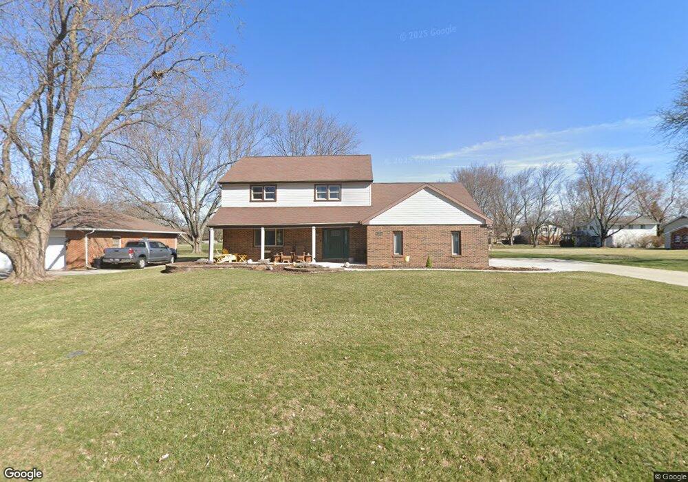
1112 Inverness Dr Findlay, OH 45840
Estimated Value: $297,000 - $383,000
3
Beds
4
Baths
2,078
Sq Ft
$160/Sq Ft
Est. Value
About This Home
This home is located at 1112 Inverness Dr, Findlay, OH 45840 and is currently estimated at $332,747, approximately $160 per square foot. 1112 Inverness Dr is a home located in Hancock County with nearby schools including Liberty-Benton Elementary School, Liberty-Benton Middle School, and Liberty-Benton High School.
Ownership History
Date
Name
Owned For
Owner Type
Purchase Details
Closed on
Jul 1, 2010
Sold by
Huber Michael Paul and Huber Kathleen Loretta
Bought by
Huber Kathleen L and Kathleen L Huber 2010 Trust
Current Estimated Value
Purchase Details
Closed on
May 1, 1987
Bought by
Huber Michael Paul and Kathleen Loret
Purchase Details
Closed on
Feb 15, 1983
Bought by
Lauger Larry D and Lauger Loralye M
Create a Home Valuation Report for This Property
The Home Valuation Report is an in-depth analysis detailing your home's value as well as a comparison with similar homes in the area
Home Values in the Area
Average Home Value in this Area
Purchase History
| Date | Buyer | Sale Price | Title Company |
|---|---|---|---|
| Huber Kathleen L | -- | None Available | |
| Huber Michael Paul | $125,900 | -- | |
| Lauger Larry D | $85,000 | -- |
Source: Public Records
Tax History Compared to Growth
Tax History
| Year | Tax Paid | Tax Assessment Tax Assessment Total Assessment is a certain percentage of the fair market value that is determined by local assessors to be the total taxable value of land and additions on the property. | Land | Improvement |
|---|---|---|---|---|
| 2024 | $3,120 | $83,920 | $12,400 | $71,520 |
| 2023 | $3,046 | $83,920 | $12,400 | $71,520 |
| 2022 | $3,016 | $83,920 | $12,400 | $71,520 |
| 2021 | $2,735 | $67,170 | $12,400 | $54,770 |
| 2020 | $2,758 | $67,170 | $12,400 | $54,770 |
| 2019 | $2,646 | $67,170 | $12,400 | $54,770 |
| 2018 | $2,084 | $58,400 | $10,780 | $47,620 |
| 2017 | $1,075 | $58,400 | $10,780 | $47,620 |
| 2016 | $2,091 | $58,400 | $10,780 | $47,620 |
| 2015 | $2,060 | $56,260 | $10,780 | $45,480 |
| 2014 | $2,119 | $57,350 | $10,780 | $46,570 |
| 2012 | $2,214 | $57,350 | $10,780 | $46,570 |
Source: Public Records
Map
Nearby Homes
- 3018 Gleneagle Dr
- 933 Laurel Ln
- 3106 Saddlebrook
- 1405 Cypress Lake
- 1310 Muirfield Dr
- 6535 Silver Lake Dr
- 925 W Melrose Ave
- 905 W Melrose Ave
- 615 Hillcrest Ave
- 3300 Crosshill Dr
- 506 Hillcrest Ave
- 643 Edith Ave
- 0 County Road 95 Unit 6097574
- 0 County Road 140
- 0 Township Highway 99
- 12325 Township Highway 99
- 126 Hillcrest Ave
- 0 County Road 223
- 0 Allen Township 142
- 304 Prentiss Ave
- 1118 Inverness Dr
- 1102 Inverness Dr
- 2906 Saint Andrews Dr
- 1115 Inverness Dr
- 1124 Inverness Dr
- 2912 Saint Andrews Dr
- 1107 Inverness Dr
- 1121 Inverness Dr
- 1101 Inverness Dr
- 1127 Inverness Dr
- 2918 Saint Andrews Dr
- 2901 Gleneagle Dr
- 2907 Gleneagle Dr
- 1112 W Bigelow Ave
- 1020 Inverness Dr
- 2907 Saint Andrews Dr
- 1106 W Bigelow Ave
- 1118 W Bigelow Ave
- 2911 Gleneagle Dr
- 2811 Saint Andrews Dr