
Seller's Agent in 2025
Michael Dorsey
Windermere North
(509) 688-3858
2 in this area
146 Total Sales
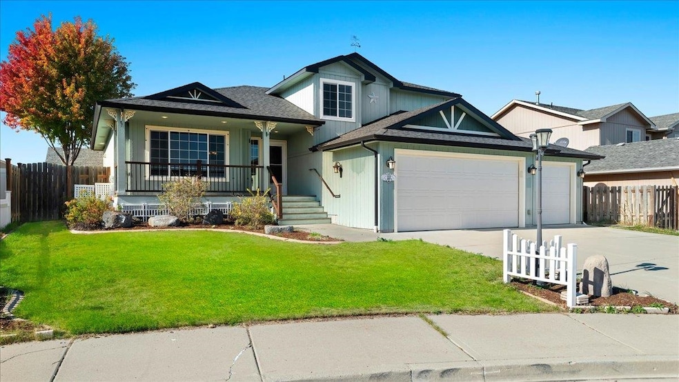


Airway Heights area 1 owner Condron built, 4 level home on a culdesac with a covered front porch! This 3+ bedroom home with 3 bathrooms and 2 family rooms offers great living spaces. With a quality and spacious kitchen that features a pantry and island with dining space that opens to a covered composite deck & stamped concrete patio surrounded by your fenced back yard – this presents good living spaces inside & out. 3 bedrooms upstairs featuring a nice sized 3⁄4 primary bath & walk in closet. The lower level is unfinished (framed with egress window) ideal for a 4th bedroom. With all new carpet, high efficiency gas furnace (with AC), this is a solid buy with a full 3 car garage. This 2300 sf home was just professionally cleaned, HVAC serviced, presents nicely & comes with all appliances including washer & dryer. Located close to North 40, Fairchild AFB, Quest Casino in a fast growing west plains established neighborhood.
Last Agent to Sell the Property
Windermere North License #106836 Listed on: 10/16/2025
| Date | Type | Sale Price | Title Company |
|---|---|---|---|
| Warranty Deed | $433,500 | Wfg National Title Insurance C | |
| Warranty Deed | $228,280 | First American Title Ins | |
| Quit Claim Deed | $39,000 | First American Title Ins Co |
| Date | Status | Loan Amount | Loan Type |
|---|---|---|---|
| Open | $425,648 | FHA | |
| Previous Owner | $182,400 | New Conventional | |
| Previous Owner | $182,350 | Construction |
| Date | Event | Price | List to Sale | Price per Sq Ft |
|---|---|---|---|---|
| 11/20/2025 11/20/25 | Sold | $433,500 | +2.0% | $187 / Sq Ft |
| 10/29/2025 10/29/25 | Pending | -- | -- | -- |
| 10/16/2025 10/16/25 | For Sale | $425,000 | -- | $183 / Sq Ft |
| Year | Tax Paid | Tax Assessment Tax Assessment Total Assessment is a certain percentage of the fair market value that is determined by local assessors to be the total taxable value of land and additions on the property. | Land | Improvement |
|---|---|---|---|---|
| 2025 | $4,119 | $409,000 | $85,000 | $324,000 |
| 2024 | $4,119 | $385,600 | $76,000 | $309,600 |
| 2023 | $3,285 | $394,700 | $76,000 | $318,700 |
| 2022 | $3,275 | $409,900 | $76,000 | $333,900 |
| 2021 | $3,130 | $286,500 | $40,000 | $246,500 |
| 2020 | $3,047 | $265,200 | $38,000 | $227,200 |
| 2019 | $2,749 | $243,800 | $38,000 | $205,800 |
| 2018 | $2,824 | $214,000 | $29,000 | $185,000 |
| 2017 | $2,555 | $207,100 | $29,000 | $178,100 |
| 2016 | $2,201 | $193,700 | $29,000 | $164,700 |
| 2015 | $2,189 | $187,500 | $29,000 | $158,500 |
| 2014 | -- | $185,000 | $29,000 | $156,000 |
| 2013 | -- | $0 | $0 | $0 |
Seller's Agent in 2025
Michael Dorsey
Windermere North
(509) 688-3858
2 in this area
146 Total Sales
Seller Co-Listing Agent in 2025
Dan Pasby
Windermere North
(509) 844-5696
1 in this area
68 Total Sales
Buyer's Agent in 2025
Christina Wyatt
Engel & Volkers Western Frontier
(509) 907-9005
2 in this area
85 Total Sales
Source: Spokane Association of REALTORS®
MLS Number: 202525621
APN: 25193.0815
Disclaimer: Certain information contained herein is derived from information provided by parties other than Homes.com. All information provided is deemed reliable, but is not guaranteed to be accurate and should be independently verified.
![]() Based on information submitted to the MLS GRID. All data is obtained from various sources and may not have been verified by broker or MLS GRID. Supplied Open House Information is subject to change without notice. All information should be independently reviewed and verified for accuracy. Properties may or may not be listed by the office/agent presenting the information. Some IDX listings have been excluded from this website. IDX information is provided exclusively for personal, non-commercial use, and may not be used for any purpose other than to identify prospective properties consumers may be interested in purchasing.Information is deemed reliable but not guaranteed.
Based on information submitted to the MLS GRID. All data is obtained from various sources and may not have been verified by broker or MLS GRID. Supplied Open House Information is subject to change without notice. All information should be independently reviewed and verified for accuracy. Properties may or may not be listed by the office/agent presenting the information. Some IDX listings have been excluded from this website. IDX information is provided exclusively for personal, non-commercial use, and may not be used for any purpose other than to identify prospective properties consumers may be interested in purchasing.Information is deemed reliable but not guaranteed.
Based on information submitted to the MLS GRID
Ask me questions while you tour the home.