Estimated Value: $388,000 - $446,000
3
Beds
3
Baths
1,536
Sq Ft
$264/Sq Ft
Est. Value
About This Home
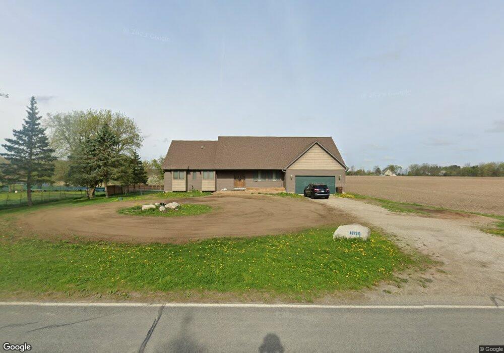
This home is located at 11120 S Wacousta Rd, Eagle, MI 48822 and is currently estimated at $405,855, approximately $264 per square foot. 11120 S Wacousta Rd is a home located in Clinton County with nearby schools including Wacousta Elementary School, Leon W. Hayes Middle School, and Grand Ledge High School.
Ownership History
Date
Name
Owned For
Owner Type
Purchase Details
Closed on
Sep 18, 2025
Sold by
Felts Sherry Lee
Bought by
Felts Sherry Lee
Current Estimated Value
Purchase Details
Closed on
Aug 15, 2025
Sold by
Burdick John O
Bought by
Burdick John O and Burdick John Oliver
Purchase Details
Closed on
Jan 4, 2010
Sold by
Bac Home Loans Servicing Lp
Bought by
Federal National Mortgage Association
Purchase Details
Closed on
Dec 9, 2009
Sold by
Austin Robert C
Bought by
Bac Home Loans Servicing Lp and Countrywide Home Loans Servicing Lp
Create a Home Valuation Report for This Property
The Home Valuation Report is an in-depth analysis detailing your home's value as well as a comparison with similar homes in the area
Home Values in the Area
Average Home Value in this Area
Purchase History
| Date | Buyer | Sale Price | Title Company |
|---|---|---|---|
| Felts Sherry Lee | -- | None Listed On Document | |
| Burdick John O | -- | Prestige Title | |
| Federal National Mortgage Association | -- | None Available | |
| Bac Home Loans Servicing Lp | $199,809 | None Available |
Source: Public Records
Tax History
| Year | Tax Paid | Tax Assessment Tax Assessment Total Assessment is a certain percentage of the fair market value that is determined by local assessors to be the total taxable value of land and additions on the property. | Land | Improvement |
|---|---|---|---|---|
| 2025 | $4,997 | $187,600 | $25,300 | $162,300 |
| 2024 | $17 | $176,650 | $23,050 | $153,600 |
| 2023 | $1,438 | $150,350 | $0 | $0 |
| 2022 | $4,007 | $135,850 | $18,200 | $117,650 |
| 2021 | $3,875 | $131,550 | $18,250 | $113,300 |
| 2020 | $3,620 | $125,900 | $17,250 | $108,650 |
| 2019 | $3,475 | $117,550 | $16,250 | $101,300 |
| 2018 | $2,911 | $106,750 | $15,400 | $91,350 |
| 2017 | $2,218 | $107,300 | $15,200 | $92,100 |
| 2016 | $2,218 | $83,800 | $14,350 | $69,450 |
| 2015 | $2,259 | $75,050 | $0 | $0 |
| 2011 | -- | $112,050 | $0 | $0 |
Source: Public Records
Map
Nearby Homes
- 11471 S Bauer Rd
- 8201 W Howe Rd
- 10880 S Francis Rd
- 11191 W Chadwick Rd
- 7713 Jon Scott Dr
- 12800 S Wright Rd
- 6260 W Chadwick Rd
- 11781 W Herbison Rd
- 11500 Eden Trail
- 4975 W Cutler Rd
- 6157 W Stoll Rd
- 7837 W Grand
- 13573 Hawaii Ave Unit 64
- 4083 W Herbison Rd
- 13748 Alaska Ave
- 11740 Kalamata Dr
- 00 Driftwood Dr
- 0 Driftwood Dr
- 3893 Sage Ln
- 3783 Wisteria Ln
- 11180 S Wacousta Rd
- 11163 S Wacousta Rd
- 11240 S Wacousta Rd
- 11245 S Wacousta Rd
- 8970 W Cutler Rd
- 9176 W Cutler Rd
- 10950 Wacousta Rd
- 8908 W Cutler Rd
- 11385 S Wacousta Rd
- 11375 S Wacousta Rd
- 9184 W Cutler Rd
- 11400 S Wacousta Rd
- 9200 W Cutler Rd
- 9249 W Cutler Rd
- 8860 W Cutler Rd
- 10906 Wacousta Rd
- 11420 S Wacousta Rd
- 9267 W Cutler Rd
- 9270 W Cutler Rd
Your Personal Tour Guide
Ask me questions while you tour the home.