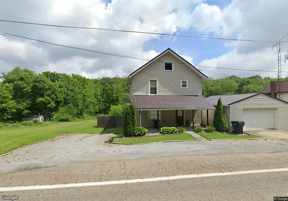
11121 State Route 644 Kensington, OH 44427
Estimated Value: $76,929 - $131,000
3
Beds
1
Bath
1,248
Sq Ft
$88/Sq Ft
Est. Value
About This Home
This home is located at 11121 State Route 644, Kensington, OH 44427 and is currently estimated at $110,232, approximately $88 per square foot. 11121 State Route 644 is a home located in Columbiana County with nearby schools including United Elementary School and United High School.
Ownership History
Date
Name
Owned For
Owner Type
Purchase Details
Closed on
Jan 28, 2016
Sold by
Minard Jason and Minard Sonya
Bought by
Cover Nathan S
Current Estimated Value
Home Financials for this Owner
Home Financials are based on the most recent Mortgage that was taken out on this home.
Original Mortgage
$70,951
Outstanding Balance
$56,652
Interest Rate
4%
Mortgage Type
New Conventional
Estimated Equity
$53,580
Purchase Details
Closed on
Mar 10, 2000
Sold by
Leishman L Irene
Bought by
Minard Jason L and Minard Trudy J
Home Financials for this Owner
Home Financials are based on the most recent Mortgage that was taken out on this home.
Original Mortgage
$31,500
Interest Rate
8.39%
Purchase Details
Closed on
Dec 29, 1998
Sold by
Leishman Robert E
Bought by
Leishman L Irene
Create a Home Valuation Report for This Property
The Home Valuation Report is an in-depth analysis detailing your home's value as well as a comparison with similar homes in the area
Home Values in the Area
Average Home Value in this Area
Purchase History
| Date | Buyer | Sale Price | Title Company |
|---|---|---|---|
| Cover Nathan S | -- | None Available | |
| Minard Jason L | $35,000 | -- | |
| Leishman L Irene | -- | -- |
Source: Public Records
Mortgage History
| Date | Status | Borrower | Loan Amount |
|---|---|---|---|
| Open | Cover Nathan S | $70,951 | |
| Previous Owner | Minard Jason L | $31,500 | |
| Closed | Minard Jason L | $3,500 |
Source: Public Records
Tax History Compared to Growth
Tax History
| Year | Tax Paid | Tax Assessment Tax Assessment Total Assessment is a certain percentage of the fair market value that is determined by local assessors to be the total taxable value of land and additions on the property. | Land | Improvement |
|---|---|---|---|---|
| 2024 | $639 | $18,490 | $3,190 | $15,300 |
| 2023 | $640 | $18,490 | $3,190 | $15,300 |
| 2022 | $583 | $18,490 | $3,190 | $15,300 |
| 2021 | $532 | $16,000 | $3,190 | $12,810 |
| 2020 | $532 | $16,000 | $3,190 | $12,810 |
| 2019 | $532 | $16,000 | $3,190 | $12,810 |
| 2018 | $496 | $14,570 | $2,910 | $11,660 |
| 2017 | $496 | $14,570 | $2,910 | $11,660 |
| 2016 | $524 | $14,460 | $3,050 | $11,410 |
| 2015 | $524 | $14,460 | $3,050 | $11,410 |
| 2014 | $541 | $14,460 | $3,050 | $11,410 |
Source: Public Records
Map
Nearby Homes
- 10143 Ohio 9
- 11281 State Route 9
- 0 Howard St
- 30382 State Route 30
- 11200 Watson Rd
- 11165 Lynchburg Rd
- 14639 Fink Rd
- 9135 Richey School Rd
- 15221 Emerick Rd
- 8004 Reef Rd NE
- 11153 Augusta Rd
- 26444 State Route 172
- 31842 Acker Rd
- 0 Sr 30 Hwy
- 0 Westward Way Unit 5149314
- 7716 N Ridge Place
- 11583 Bower Rd
- 24219 W Egypt Rd
- 6964 Lakeview Dr
- 5267 Apollo Rd NE Unit 32
- 11113 State Route 644
- 11127 State Route 644
- 11109 State Route 644
- 11064 State Route 644
- 29186 Maple St
- 11083 State Route 644
- 11061 State Route 644
- 29089 High St
- 11053 State Route 644
- 29075 High St
- 29085 Front St
- 11051 State Route 644
- 29063 Front St
- 29120 Maple St
- 29053 Front St
- 11037 State Route 644
- 29756 State Route 30
- 29025 Front St
- 29025 Front St
- 11036 Canal St