
Seller's Agent in 2025
Maura Neill
RE/MAX
(404) 919-5565
2 in this area
107 Total Sales
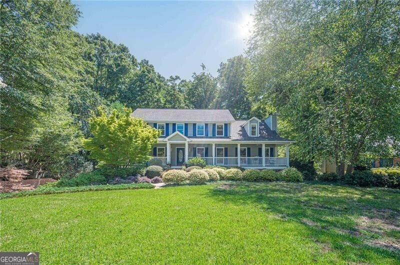
Nestled in a serene, wooded setting with the peaceful sound of a bubbling creek just beyond the backyard, this gracious traditional home offers everything you need to move right in and fall in love. With its inviting rocking chair front porch stretching across the entire front of the home, it's the kind of place where morning coffee tastes better and evenings invite sweet tea and conversation. This home is ready for the next owner to fall in love, to add their personal touches and make it their own. Step through the front door into a welcoming hardwood foyer, setting the tone for the abundant space throughout. To your left, the formal living room is the perfect canvas - ideal as a music room, home library, or quiet study. To the right, the formal dining room is ready to host holidays, dinner parties, or weeknight meals alike. At the heart of the home, the spacious kitchen delivers both charm and function with plentiful cabinetry, a center island, a built-in desk, and a pantry. You'll love the stainless steel appliances, including wall oven/microwave combo, new electric cooktop, and dishwasher, making it easy to settle in and start cooking. The sunny breakfast room, framed by a bay window, overlooks the private, wooded backyard -a perfect spot to birdwatch over brunch. The fireside family room is a cozy retreat with a wood-burning brick fireplace, raised hearth, and warm ambiance, inviting you to curl up with a good book or gather with loved ones. A main floor bedroom with a private entrance to the full tiled bath offers ideal space for guests, multigenerational living, or a private office. The main floor also features a separate laundry room, with storage and a washer and dryer that remain with the home. Upstairs, the oversized primary suite is a true sanctuary, complete with a sitting room and tranquil bay window overlooking the lush backyard. The expansive en suite bathroom features a vaulted ceiling, skylight, separate shower and water closet, soaking tub, make-up vanity area, double sinks, and two enormous walk-in closets - plenty of room to dream and design your ideal spa retreat. Two additional spacious bedrooms share a tiled hall bath and hall linen closet. The finished basement offers a world of potential - home theater, office, gym, game room, playroom - with a tiled half bath (plus closet and sump pump) and two sets of French doors opening to the lush backyard and covered patio below the main-level deck - perfect for al fresco dining, relaxing, or entertaining. A drive-under, side-entry 2-car garage includes even more space for storage, a workshop area, and a separate door to the backyard. With Hardiplank siding, abundant storage throughout, and beautiful setting, this warm, well-maintained home is ready for its next chapter - and its next lucky owner. Come make it yours!
Last Agent to Sell the Property
RE/MAX Around Atlanta License #296541 Listed on: 08/01/2025
| Date | Type | Sale Price | Title Company |
|---|---|---|---|
| Special Warranty Deed | $530,000 | None Listed On Document | |
| Special Warranty Deed | $530,000 | None Listed On Document | |
| Deed | $173,600 | -- |
| Date | Status | Loan Amount | Loan Type |
|---|---|---|---|
| Open | $503,500 | New Conventional | |
| Closed | $503,500 | New Conventional | |
| Closed | $0 | No Value Available |
| Date | Event | Price | Change | Sq Ft Price |
|---|---|---|---|---|
| 09/04/2025 09/04/25 | Sold | $530,000 | -5.4% | $219 / Sq Ft |
| 08/17/2025 08/17/25 | Pending | -- | -- | -- |
| 08/01/2025 08/01/25 | For Sale | $560,000 | -- | $231 / Sq Ft |
| Year | Tax Paid | Tax Assessment Tax Assessment Total Assessment is a certain percentage of the fair market value that is determined by local assessors to be the total taxable value of land and additions on the property. | Land | Improvement |
|---|---|---|---|---|
| 2024 | $1,703 | $201,300 | $44,000 | $157,300 |
| 2023 | $1,703 | $201,300 | $44,000 | $157,300 |
| 2022 | $1,059 | $125,196 | $28,000 | $97,196 |
| 2021 | $1,075 | $125,196 | $28,000 | $97,196 |
| 2020 | $1,075 | $125,196 | $28,000 | $97,196 |
| 2019 | $970 | $112,916 | $24,000 | $88,916 |
| 2018 | $970 | $112,916 | $24,000 | $88,916 |
| 2017 | $778 | $112,916 | $24,000 | $88,916 |
| 2016 | $684 | $99,268 | $24,000 | $75,268 |
| 2015 | $745 | $99,268 | $24,000 | $75,268 |
| 2014 | $737 | $95,096 | $0 | $0 |
Seller's Agent in 2025
Maura Neill
RE/MAX
(404) 919-5565
2 in this area
107 Total Sales
Buyer's Agent in 2025
Carly Harden
Ansley RE|Christie's Int'l RE
(770) 455-2193
14 in this area
42 Total Sales
Source: Georgia MLS
MLS Number: 10576177
APN: 19-0039-0-070-0
Disclaimer: Certain information contained herein is derived from information provided by parties other than Homes.com. All information provided is deemed reliable, but is not guaranteed to be accurate and should be independently verified.
![]() The data relating to real estate for sale on this web site comes in part from the Broker Reciprocity Program of Georgia MLS. Real estate listings held by brokerage firms other than Redfin are marked with the Broker Reciprocity logo and detailed information about them includes the name of the listing brokers. Information deemed reliable but not guaranteed. Copyright 2025 Georgia MLS. All rights reserved.
The data relating to real estate for sale on this web site comes in part from the Broker Reciprocity Program of Georgia MLS. Real estate listings held by brokerage firms other than Redfin are marked with the Broker Reciprocity logo and detailed information about them includes the name of the listing brokers. Information deemed reliable but not guaranteed. Copyright 2025 Georgia MLS. All rights reserved.