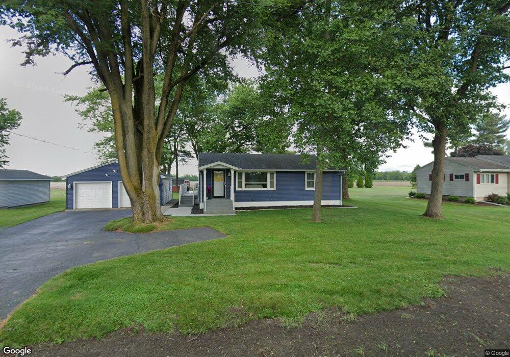
11152 S 1025 W Wanatah, IN 46390
Estimated Value: $237,527 - $266,000
3
Beds
2
Baths
1,008
Sq Ft
$248/Sq Ft
Est. Value
About This Home
This home is located at 11152 S 1025 W, Wanatah, IN 46390 and is currently estimated at $250,382, approximately $248 per square foot. 11152 S 1025 W is a home located in LaPorte County with nearby schools including South Central Elementary School and South Central Junior/Senior High School.
Ownership History
Date
Name
Owned For
Owner Type
Purchase Details
Closed on
Oct 14, 2019
Sold by
Krug David C
Bought by
Hawkins Kathryn I and Soller Kyle
Current Estimated Value
Home Financials for this Owner
Home Financials are based on the most recent Mortgage that was taken out on this home.
Original Mortgage
$185,000
Outstanding Balance
$161,736
Interest Rate
3.4%
Mortgage Type
New Conventional
Estimated Equity
$88,646
Purchase Details
Closed on
Jun 15, 2018
Sold by
Hartman Kathy Dawn and Froedge Patti
Bought by
Krug David C
Purchase Details
Closed on
Apr 12, 2007
Sold by
Hunsley Eileen M
Bought by
Hunsley Eileen M and Donald H Hunsley Family Trust
Purchase Details
Closed on
Nov 22, 1999
Sold by
Hunsley Donald H and Hunsley Eileen M
Bought by
Hunsley Donald H and Hunsley Eileen M
Create a Home Valuation Report for This Property
The Home Valuation Report is an in-depth analysis detailing your home's value as well as a comparison with similar homes in the area
Home Values in the Area
Average Home Value in this Area
Purchase History
| Date | Buyer | Sale Price | Title Company |
|---|---|---|---|
| Hawkins Kathryn I | -- | Chicago Title | |
| Krug David C | -- | Chicago Title | |
| Hunsley Eileen M | -- | None Available | |
| Hunsley Donald H | -- | None Available |
Source: Public Records
Mortgage History
| Date | Status | Borrower | Loan Amount |
|---|---|---|---|
| Open | Hawkins Kathryn I | $185,000 |
Source: Public Records
Tax History Compared to Growth
Tax History
| Year | Tax Paid | Tax Assessment Tax Assessment Total Assessment is a certain percentage of the fair market value that is determined by local assessors to be the total taxable value of land and additions on the property. | Land | Improvement |
|---|---|---|---|---|
| 2024 | $1,518 | $169,900 | $24,900 | $145,000 |
| 2023 | $1,439 | $168,000 | $24,900 | $143,100 |
| 2022 | $1,459 | $172,300 | $24,900 | $147,400 |
| 2021 | $1,459 | $161,800 | $24,900 | $136,900 |
| 2020 | $1,483 | $161,800 | $24,900 | $136,900 |
| 2019 | $858 | $107,100 | $21,500 | $85,600 |
| 2018 | $110 | $88,800 | $21,500 | $67,300 |
| 2017 | $109 | $87,000 | $21,500 | $65,500 |
| 2016 | $109 | $86,900 | $21,500 | $65,400 |
| 2014 | $68 | $83,200 | $23,400 | $59,800 |
Source: Public Records
Map
Nearby Homes
- 105 Earl St
- 627 Fieldcrest Cir
- 116 Sprunger Dr
- 305 N Ohio St
- 207 N Washington St
- 104 W Cross St
- 106 N Illinois St Unit 266
- 9552 S Bigelow Mill Rd
- 0 W Hwy 30 Unit GNR545374
- W 800 S V L
- 6465 W 1100 S
- 627 E 300 S
- 83 Kaper Ln
- 87 Kaper Ln
- 421 Amy Rose Ln
- 0 Porters Vale Blvd Unit GNR544918
- 0 St Road 2 Unit GNR544911
- 168 Jamestown Ave
- 0 Parcel B 325 E
- 0 Parcel A 325 E
- 11172 S 1025 W
- 11122 S 1025 W
- 11212 S 1025 W
- 11102 S 1025 W
- 11232 S 1025 W
- 11052 S 1025 W
- 11042 S 1025 W
- 11141 S 1025 W
- 11025 S 1025 W
- 11252 S 1025 W
- 11022 S 1025 W
- 11271 S 1025 W
- 11282 S 1025 W
- 9021 S 1025 W
- 11301 S 1025 W
- 11176 S Us Highway 421
- 11333 S 1025 W
- 11114 S Us Hwy
- 11114 S Us Highway 421
- 11114 U S 421