
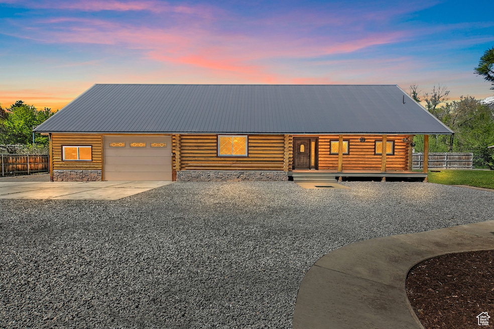

1118 N 750 W Provo, UT 84604
Rivergrove NeighborhoodEstimated payment $4,234/month
Total Views
69,713
3
Beds
1.5
Baths
1,697
Sq Ft
$424
Price per Sq Ft
Highlights
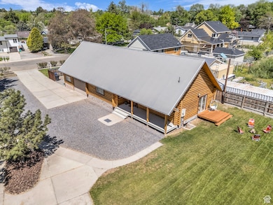
- RV or Boat Parking
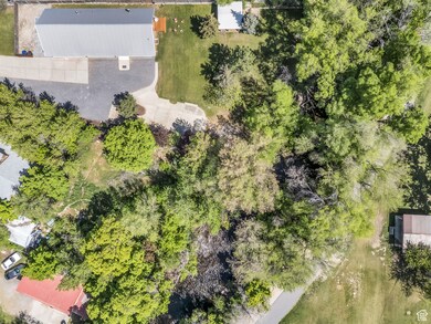
- 0.54 Acre Lot
- Mountain View
- Waterfront
- Fruit Trees
- Private Lot
About This Home
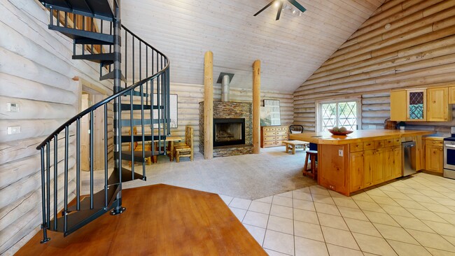
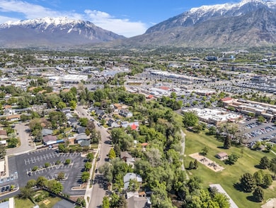
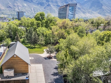
RARE RIVERFRONT LOG HOME ON HALF ACRE IN THE HEART OF PROVO! Own 141 feet of private Provo River frontage on a serene half-acre, just minutes from BYU, UVU, Utah Valley Hospital, excellent shopping and dining, scenic walking trails, and year-round outdoor recreation. This rustic-modern log home blends charm and function with cedar beams, a stone gas fireplace, jetted tub, updated stainless steel appliances (all appliances included), and a spiral staircase leading to a large loft that can be converted into two additional bedrooms and an additional bath-or used as a spacious family room, guest space, or both. The property also features an oversized 810-square-foot garage with a 9-foot door, large shed, RV parking, two laundry hookups, a reverse osmosis water system, a Rachio Bluetooth sprinkler system, Nest thermostat, and Google Fiber. Feel like you're on vacation every day-enjoy tubing, fishing, or skipping rocks from your own backyard. Whether you're looking for a full-time residence or a peaceful retreat, this rare Provo gem offers comfort, convenience, and natural beauty-and it won't last long. All information deemed reliable, but not guaranteed. Buyer and Buyer's Agent to verify all.
Listing Agent
Coldwell Banker Realty (Union Heights) License #9604125 Listed on: 05/08/2025
Home Details
Home Type
- Single Family
Est. Annual Taxes
- $2,741
Year Built
- Built in 1995
Lot Details
- 0.54 Acre Lot
- Waterfront
- Creek or Stream
- Partially Fenced Property
- Landscaped
- Private Lot
- Secluded Lot
- Fruit Trees
- Mature Trees
- Pine Trees
- Wooded Lot
- Property is zoned Single-Family
Parking
- 3 Car Attached Garage
- 20 Open Parking Spaces
- RV or Boat Parking
Home Design
- Cabin
- Pitched Roof
- Metal Roof
- Stone Siding
- Log Siding
Interior Spaces
- 1,697 Sq Ft Home
- 2-Story Property
- Vaulted Ceiling
- Ceiling Fan
- Self Contained Fireplace Unit Or Insert
- Gas Log Fireplace
- Double Pane Windows
- Blinds
- French Doors
- Sliding Doors
- Mountain Views
- Smart Thermostat
Kitchen
- Gas Oven
- Gas Range
- Free-Standing Range
- Microwave
Flooring
- Wood
- Carpet
- Tile
Bedrooms and Bathrooms
- 3 Bedrooms | 2 Main Level Bedrooms
- Primary Bedroom on Main
- Hydromassage or Jetted Bathtub
- Bathtub With Separate Shower Stall
Laundry
- Dryer
- Washer
Eco-Friendly Details
- Sprinkler System
Outdoor Features
- Open Patio
- Storage Shed
- Outbuilding
- Porch
Schools
- Westridge Elementary School
- Provo High School
Utilities
- Forced Air Heating and Cooling System
- Natural Gas Connected
Community Details
- No Home Owners Association
- Davies Subdivision
Listing and Financial Details
- Assessor Parcel Number 37-049-0002
Map
Create a Home Valuation Report for This Property
The Home Valuation Report is an in-depth analysis detailing your home's value as well as a comparison with similar homes in the area
Home Values in the Area
Average Home Value in this Area
Tax History
| Year | Tax Paid | Tax Assessment Tax Assessment Total Assessment is a certain percentage of the fair market value that is determined by local assessors to be the total taxable value of land and additions on the property. | Land | Improvement |
|---|---|---|---|---|
| 2024 | $2,741 | $269,775 | $0 | $0 |
| 2023 | $2,724 | $264,330 | $0 | $0 |
| 2022 | $2,529 | $247,500 | $0 | $0 |
| 2021 | $1,897 | $323,700 | $129,700 | $194,000 |
| 2020 | $1,840 | $294,300 | $117,900 | $176,400 |
| 2019 | $1,631 | $271,300 | $117,900 | $153,400 |
| 2018 | $1,438 | $242,600 | $109,200 | $133,400 |
| 2017 | $1,364 | $126,445 | $0 | $0 |
| 2016 | $1,302 | $112,530 | $0 | $0 |
| 2015 | $1,133 | $99,000 | $0 | $0 |
| 2014 | $977 | $88,990 | $0 | $0 |
Source: Public Records
Property History
| Date | Event | Price | Change | Sq Ft Price |
|---|---|---|---|---|
| 05/30/2025 05/30/25 | Pending | -- | -- | -- |
| 05/06/2025 05/06/25 | For Sale | $719,000 | -- | $424 / Sq Ft |
Source: UtahRealEstate.com
Purchase History
| Date | Type | Sale Price | Title Company |
|---|---|---|---|
| Warranty Deed | -- | Greenbrier Title | |
| Interfamily Deed Transfer | -- | Liberty Title & Escrow Co |
Source: Public Records
Mortgage History
| Date | Status | Loan Amount | Loan Type |
|---|---|---|---|
| Previous Owner | $104,000 | New Conventional | |
| Previous Owner | $196,500 | New Conventional | |
| Previous Owner | $206,400 | New Conventional |
Source: Public Records
About the Listing Agent
Lynn recognizes that every client is unique and strives to make each transaction as streamlined as possible. She thrives in finding solutions to problems which may arise and understands that it is of the utmost importance to be available for her clients.
Lynn began her career in real estate in Los Angeles in 1998. Initially working at a commercial real estate brokerage, then transitioning to working for a prominent developer in downtown Los Angeles.
Prior to working in real
Lynn's Other Listings
Source: UtahRealEstate.com
MLS Number: 2083492
APN: 37-049-0002
Disclaimer: Certain information contained herein is derived from information provided by parties other than Homes.com. All information provided is deemed reliable, but is not guaranteed to be accurate and should be independently verified.
![]() IDX information is provided exclusively for consumers’ personal, non-commercial use, that it may not be used for any purpose other than to identify prospective properties consumers may be interested in purchasing, and that the data is deemed reliable but is not guaranteed accurate by the MLS. Licensor is only providing the MLS Content and not other sources of data provided in the Product.
IDX information is provided exclusively for consumers’ personal, non-commercial use, that it may not be used for any purpose other than to identify prospective properties consumers may be interested in purchasing, and that the data is deemed reliable but is not guaranteed accurate by the MLS. Licensor is only providing the MLS Content and not other sources of data provided in the Product.
Based on information from the Wasatch Front Regional Multiple Listing Service, Inc.. All data, including all measurements and calculations of area, is obtained from various sources and has not been, and will not be, verified by broker or the MLS. All information should be independently reviewed and verified for accuracy. Properties may or may not be listed by the office/agent presenting the information.
Nearby Homes
- 1227 Riverside Ave Unit 50
- 1254 N 800 W
- 1260 N 800 W
- 1268 N 800 W
- 1303 Riverside Ave Unit 32
- 1320 N 800 W
- 1326 N 800 W
- 1330 N 800 W
- 1063 W 1100 N
- 556 W 800 N Unit 15
- 556 W 800 N Unit 18
- 845 N 950 W
- 770 W 700 N
- 861 W Columbia Ln Unit 21
- 1102 W 860 N
- 682 N 700 W
- 1130 W 1200 N
- 1559 Riverside Avenue Ave N Unit 2
- 595 N 600 W
- 1163 W 820 N