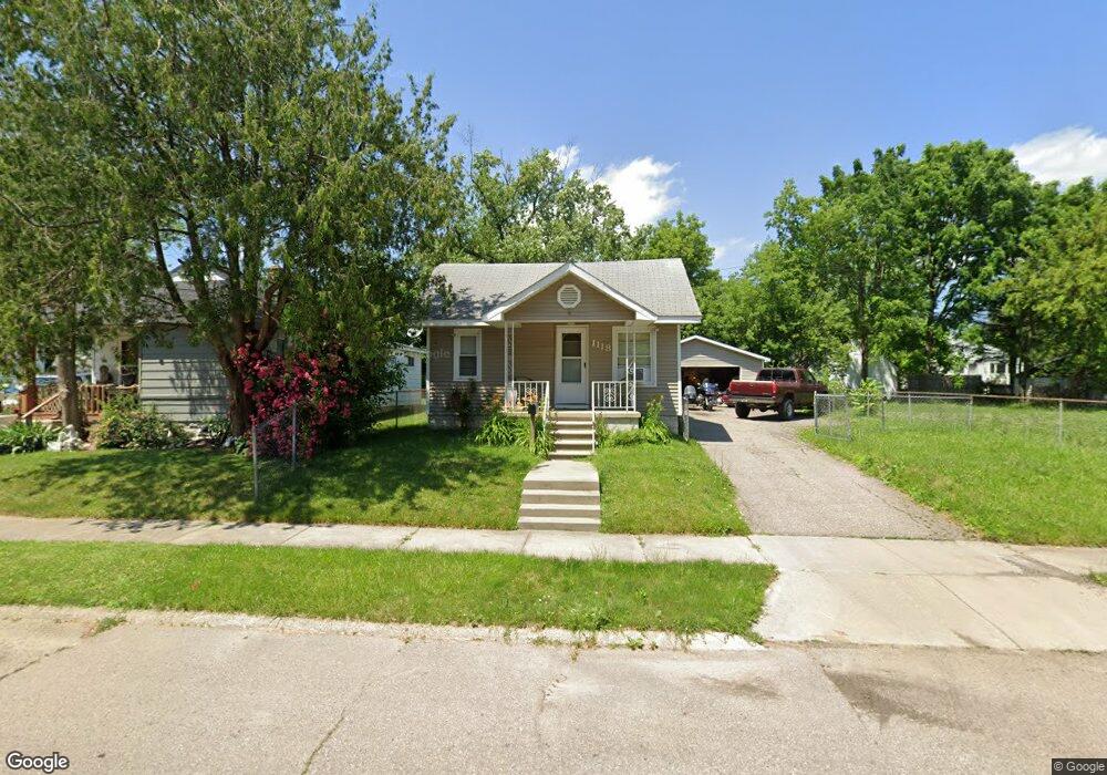
1118 Pinehurst Ave Flint, MI 48507
South Side NeighborhoodEstimated Value: $44,000 - $68,000
3
Beds
1
Bath
890
Sq Ft
$60/Sq Ft
Est. Value
About This Home
This home is located at 1118 Pinehurst Ave, Flint, MI 48507 and is currently estimated at $53,676, approximately $60 per square foot. 1118 Pinehurst Ave is a home located in Genesee County with nearby schools including Neithercut Elementary School, Flint Southwestern Classical Academy, and International Academy of Flint (K-12).
Ownership History
Date
Name
Owned For
Owner Type
Purchase Details
Closed on
Apr 9, 2021
Sold by
Martin Lynn A and Martin Nancy Lee
Bought by
Smith Scott M and Smith Raeann M
Current Estimated Value
Purchase Details
Closed on
Feb 4, 2009
Sold by
Federal Home Loan Mortgage Corp
Bought by
Martin Nancy Lee and Martin Lynn A
Purchase Details
Closed on
Jul 23, 2008
Sold by
Danko John M and Danko Melissa L
Bought by
Federal Home Loan Mortgage Corporation
Create a Home Valuation Report for This Property
The Home Valuation Report is an in-depth analysis detailing your home's value as well as a comparison with similar homes in the area
Home Values in the Area
Average Home Value in this Area
Purchase History
| Date | Buyer | Sale Price | Title Company |
|---|---|---|---|
| Smith Scott M | $17,500 | None Available | |
| Martin Nancy Lee | $16,200 | Warranty Title Agency Llc | |
| Federal Home Loan Mortgage Corporation | $68,772 | None Available |
Source: Public Records
Tax History
| Year | Tax Paid | Tax Assessment Tax Assessment Total Assessment is a certain percentage of the fair market value that is determined by local assessors to be the total taxable value of land and additions on the property. | Land | Improvement |
|---|---|---|---|---|
| 2025 | $1,090 | $21,500 | $0 | $0 |
| 2024 | $984 | $22,300 | $0 | $0 |
| 2023 | $965 | $18,000 | $0 | $0 |
| 2022 | $0 | $15,200 | $0 | $0 |
| 2021 | $1,005 | $13,600 | $0 | $0 |
| 2020 | $912 | $13,600 | $0 | $0 |
| 2019 | $920 | $14,100 | $0 | $0 |
| 2018 | $1,033 | $12,200 | $0 | $0 |
| 2017 | $1,005 | $0 | $0 | $0 |
| 2016 | $998 | $0 | $0 | $0 |
| 2015 | -- | $0 | $0 | $0 |
| 2014 | -- | $0 | $0 | $0 |
| 2012 | -- | $15,000 | $0 | $0 |
Source: Public Records
Map
Nearby Homes
- 1122 Markham St
- 1210 Pinehurst Ave
- 1318 Ingleside Ave
- 1234 Huron St
- 1310 Huron St
- 1310 Alvord Ave
- 912 Huron St
- 846 W Hemphill Rd
- 1627 Blackberry Ln
- 845 Alvord Ave
- 1028 Campbell St
- 1826 Greenbrook Ln
- 805 Alvord Ave
- 4502 Huckleberry Ln
- 1410 Berrywood Ln
- 806 Alvord Ave
- 1130 W Atherton Rd
- 1902 Crestbrook Ln
- 842 Leland St
- 717 Huron St
- 1110 Pinehurst Ave
- 1122 Pinehurst Ave
- 1105 Ingleside Ave
- 1115 Ingleside Ave
- 1130 Pinehurst Ave
- 1123 Ingleside Ave
- 1102 Pinehurst Ave
- 1109 Ingleside Ave
- 1046 Pinehurst Ave
- 1117 Pinehurst Ave
- 1129 Ingleside Ave
- 1113 Pinehurst Ave
- 1121 Pinehurst Ave
- 1105 Pinehurst Ave
- 1129 Pinehurst Ave
- 1043 Ingleside Ave
- 1042 Pinehurst Ave
- 1101 Pinehurst Ave
- 1202 Pinehurst Ave
- 1201 Ingleside Ave
Your Personal Tour Guide
Ask me questions while you tour the home.