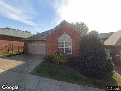
112 Avalon Path Georgetown, KY 40324
Northeast Georgetown NeighborhoodEstimated Value: $315,000 - $326,000
2
Beds
2
Baths
1,777
Sq Ft
$180/Sq Ft
Est. Value
About This Home
This home is located at 112 Avalon Path, Georgetown, KY 40324 and is currently estimated at $319,508, approximately $179 per square foot. 112 Avalon Path is a home located in Scott County with nearby schools including Anne Mason Elementary School, Creekside Elementary School, and Scott County Middle School.
Ownership History
Date
Name
Owned For
Owner Type
Purchase Details
Closed on
Sep 1, 2015
Sold by
Pumphrey Karla H and Pumphrey Paul J
Bought by
The Karla H Pumphrey Living Trust
Current Estimated Value
Purchase Details
Closed on
Aug 28, 2015
Sold by
Hassloch Milo A and Osburn Connie
Bought by
Pumphrey Karla H
Purchase Details
Closed on
Jul 21, 2006
Sold by
Myers Robert L and Myers Lee Ann
Bought by
Hassloch Hugo and Hassloch Bonnie R
Purchase Details
Closed on
Apr 25, 2006
Sold by
Byer Homes Ltd Trust
Bought by
Myers Robert L and Myers Lee Ann
Home Financials for this Owner
Home Financials are based on the most recent Mortgage that was taken out on this home.
Original Mortgage
$159,324
Interest Rate
6.33%
Mortgage Type
Construction
Create a Home Valuation Report for This Property
The Home Valuation Report is an in-depth analysis detailing your home's value as well as a comparison with similar homes in the area
Home Values in the Area
Average Home Value in this Area
Purchase History
| Date | Buyer | Sale Price | Title Company |
|---|---|---|---|
| The Karla H Pumphrey Living Trust | -- | Attorney | |
| Pumphrey Karla H | $92,250 | Attorney | |
| Hassloch Hugo | $210,325 | None Available | |
| Myers Robert L | $45,000 | None Available |
Source: Public Records
Mortgage History
| Date | Status | Borrower | Loan Amount |
|---|---|---|---|
| Open | Harney Danny R | $100,000 | |
| Previous Owner | Myers Robert L | $159,324 |
Source: Public Records
Tax History Compared to Growth
Tax History
| Year | Tax Paid | Tax Assessment Tax Assessment Total Assessment is a certain percentage of the fair market value that is determined by local assessors to be the total taxable value of land and additions on the property. | Land | Improvement |
|---|---|---|---|---|
| 2024 | $1,962 | $264,500 | $0 | $0 |
| 2023 | $1,897 | $255,600 | $40,000 | $215,600 |
| 2022 | $1,605 | $229,300 | $35,000 | $194,300 |
| 2021 | $1,695 | $220,400 | $35,000 | $185,400 |
| 2020 | $1,531 | $217,500 | $35,000 | $182,500 |
| 2019 | $1,555 | $217,500 | $0 | $0 |
| 2018 | $1,728 | $199,100 | $0 | $0 |
| 2017 | $1,736 | $199,100 | $0 | $0 |
| 2016 | $1,589 | $197,300 | $0 | $0 |
| 2015 | $1,579 | $197,300 | $0 | $0 |
| 2014 | $1,337 | $161,300 | $0 | $0 |
| 2011 | $101 | $163,300 | $0 | $0 |
Source: Public Records
Map
Nearby Homes
- 156 Camp Creek Way
- 124 Coachman Place
- 199 Pavilion Dr
- LOT 26 Lawson Dr
- 106 This Way Home Dr
- 109 High Hope Ln
- 1060 Degaris Mill Rd
- 110 Elm St
- 604 Poplar St
- 110 Blackberry Ln
- 108 Blackberry Ln
- 149 Blackberry Ln
- 153 Riviera Dr
- 508 Poplar St
- 111 Blackberry Ln
- 107 Blackberry Ln
- 117 Blackberry Ln
- 119 Blackberry Ln
- 121 Blackberry Ln
- 123 Blackberry Ln
- 112 Avalon Path
- 110 Avalon Path
- 114 Avalon Path
- 108 Avalon Path
- 112 Echo Path Unit 10
- 116 Avalon Path
- 113 Avalon Path
- 111 Avalon Path
- 110 Echo Path
- 106 Avalon Path Unit 10
- 104 Echo Path
- 109 Avalon Path
- 117 Avalon Path
- 107 Avalon Path
- 108 Echo Path
- 117 Echo Path
- 104 Avalon Path
- 115 Echo Path
- 119 Echo Path
- 113 Echo Path
