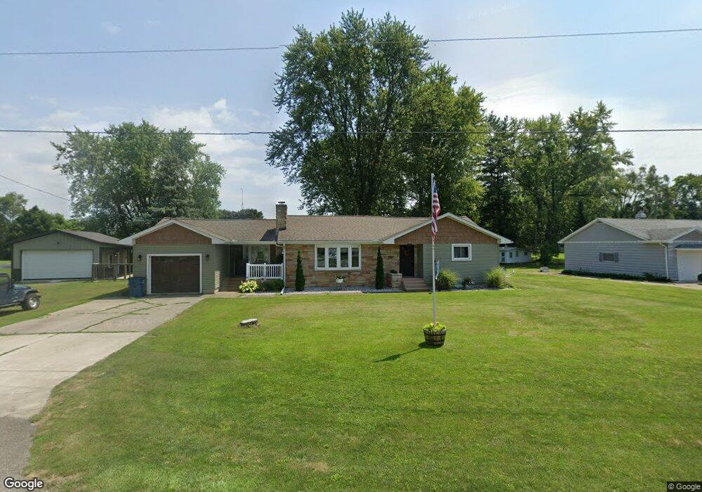
112 Forest St Napoleon, OH 43545
Estimated Value: $168,000 - $184,000
3
Beds
2
Baths
1,572
Sq Ft
$111/Sq Ft
Est. Value
About This Home
This home is located at 112 Forest St, Napoleon, OH 43545 and is currently estimated at $175,232, approximately $111 per square foot. 112 Forest St is a home located in Henry County with nearby schools including Napoleon Elementary School and Napoleon Junior/Senior High School.
Ownership History
Date
Name
Owned For
Owner Type
Purchase Details
Closed on
Aug 31, 2000
Sold by
Hull Bertia
Bought by
Waisner Chad C and Waisner Esther L
Current Estimated Value
Home Financials for this Owner
Home Financials are based on the most recent Mortgage that was taken out on this home.
Original Mortgage
$68,800
Outstanding Balance
$25,359
Interest Rate
8.26%
Mortgage Type
New Conventional
Estimated Equity
$149,873
Create a Home Valuation Report for This Property
The Home Valuation Report is an in-depth analysis detailing your home's value as well as a comparison with similar homes in the area
Home Values in the Area
Average Home Value in this Area
Purchase History
| Date | Buyer | Sale Price | Title Company |
|---|---|---|---|
| Waisner Chad C | $86,000 | -- |
Source: Public Records
Mortgage History
| Date | Status | Borrower | Loan Amount |
|---|---|---|---|
| Open | Waisner Chad C | $68,800 |
Source: Public Records
Tax History Compared to Growth
Tax History
| Year | Tax Paid | Tax Assessment Tax Assessment Total Assessment is a certain percentage of the fair market value that is determined by local assessors to be the total taxable value of land and additions on the property. | Land | Improvement |
|---|---|---|---|---|
| 2024 | $1,962 | $45,730 | $9,710 | $36,020 |
| 2023 | $1,962 | $45,730 | $9,710 | $36,020 |
| 2022 | $1,962 | $80,120 | $11,040 | $69,080 |
| 2021 | $1,960 | $40,060 | $5,520 | $34,540 |
| 2020 | $2,311 | $40,060 | $5,520 | $34,540 |
| 2019 | $2,384 | $35,240 | $5,260 | $29,980 |
| 2018 | $2,408 | $35,240 | $5,260 | $29,980 |
| 2017 | $2,347 | $35,240 | $5,260 | $29,980 |
| 2016 | $1,706 | $31,560 | $5,260 | $26,300 |
| 2015 | $1,679 | $31,560 | $5,260 | $26,300 |
| 2014 | $1,788 | $31,560 | $5,260 | $26,300 |
| 2013 | $1,788 | $31,560 | $5,260 | $26,300 |
Source: Public Records
Map
Nearby Homes
- 212 E High St
- 405 W High St
- 16052 State Route 424
- H011 County Road 17
- 75 Capri Dr
- 43 Oak Dr
- 6767 Independence Rd
- 00 County Road 14
- 0 Westmoreland Ave
- 29232 Coressel Rd
- 00 Westmoreland Ave
- 1374 Clairmont Ave
- 900 Welsted St
- 707 Park St
- 1113 Clairmont Ave
- 1314 Clairmont Ave
- 1214 Clairmont Ave
- 1354 Clairmont Ave
- 725 Sheffield Ave
- 29432 State Route 18