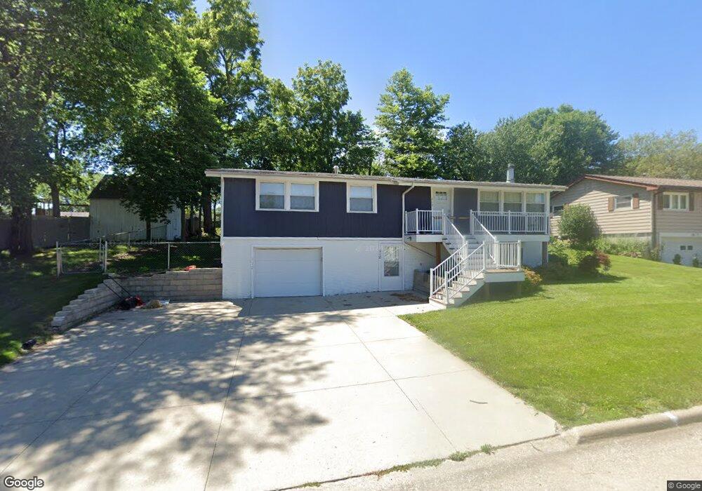
112 Foster St West Branch, IA 52358
Estimated Value: $235,000 - $267,907
4
Beds
2
Baths
1,152
Sq Ft
$219/Sq Ft
Est. Value
About This Home
This home is located at 112 Foster St, West Branch, IA 52358 and is currently estimated at $252,227, approximately $218 per square foot. 112 Foster St is a home located in Cedar County with nearby schools including Hoover Elementary School, West Branch Middle School, and West Branch High School.
Ownership History
Date
Name
Owned For
Owner Type
Purchase Details
Closed on
Nov 12, 2020
Sold by
Klein Glendon M and Klein Lindsay M
Bought by
Sheller Jane and Meyer Maureen Elizabeth
Current Estimated Value
Home Financials for this Owner
Home Financials are based on the most recent Mortgage that was taken out on this home.
Original Mortgage
$155,250
Outstanding Balance
$137,519
Interest Rate
2.8%
Mortgage Type
New Conventional
Estimated Equity
$114,708
Purchase Details
Closed on
Aug 4, 2015
Sold by
Prusha Michael J and Prusha Constance
Bought by
Klein Glendon and Shultz Jesse
Home Financials for this Owner
Home Financials are based on the most recent Mortgage that was taken out on this home.
Original Mortgage
$140,000
Interest Rate
4.03%
Mortgage Type
New Conventional
Create a Home Valuation Report for This Property
The Home Valuation Report is an in-depth analysis detailing your home's value as well as a comparison with similar homes in the area
Home Values in the Area
Average Home Value in this Area
Purchase History
| Date | Buyer | Sale Price | Title Company |
|---|---|---|---|
| Sheller Jane | $207,000 | None Listed On Document | |
| Klein Glendon | $114,000 | None Available |
Source: Public Records
Mortgage History
| Date | Status | Borrower | Loan Amount |
|---|---|---|---|
| Open | Sheller Jane | $155,250 | |
| Previous Owner | Klein Glendon | $140,000 | |
| Closed | Sheller Jane | $41,400 |
Source: Public Records
Tax History Compared to Growth
Tax History
| Year | Tax Paid | Tax Assessment Tax Assessment Total Assessment is a certain percentage of the fair market value that is determined by local assessors to be the total taxable value of land and additions on the property. | Land | Improvement |
|---|---|---|---|---|
| 2025 | $3,998 | $250,400 | $29,920 | $220,480 |
| 2024 | $3,998 | $245,550 | $29,920 | $215,630 |
| 2023 | $3,786 | $236,020 | $29,920 | $206,100 |
| 2022 | $3,528 | $191,410 | $28,160 | $163,250 |
| 2021 | $3,386 | $191,410 | $28,160 | $163,250 |
| 2020 | $3,282 | $167,360 | $24,640 | $142,720 |
| 2019 | $2,042 | $111,950 | $24,640 | $142,720 |
| 2018 | $1,998 | $111,950 | $0 | $0 |
| 2017 | $1,998 | $105,370 | $0 | $0 |
| 2016 | $2,298 | $129,970 | $0 | $0 |
| 2015 | $2,290 | $128,940 | $0 | $0 |
| 2014 | $2,290 | $128,940 | $0 | $0 |
Source: Public Records
Map
Nearby Homes
- 120 N Downey St
- 127 N Downey St
- 426 N 1st St
- 611 Riley Ln
- 173 Hilltop Dr
- 609 W Orange St
- 316 S Maple St
- 121 Northridge Dr Unit 121-139
- 360 Cookson Dr
- 314 Sycamore Dr
- 312 Sycamore Dr
- 316 Sycamore Dr
- 212 Dawson Dr
- 719 Sullivan St
- 521 N 4th St Unit Louise Court Condos
- 557 N 4th St
- Lot 17 Meadows Subdivision Part 5
- 3 Grant St Unit GR3
- 33 Lou Henry Ln Unit AM33
- 35 Lou Henry Ln Unit AM35