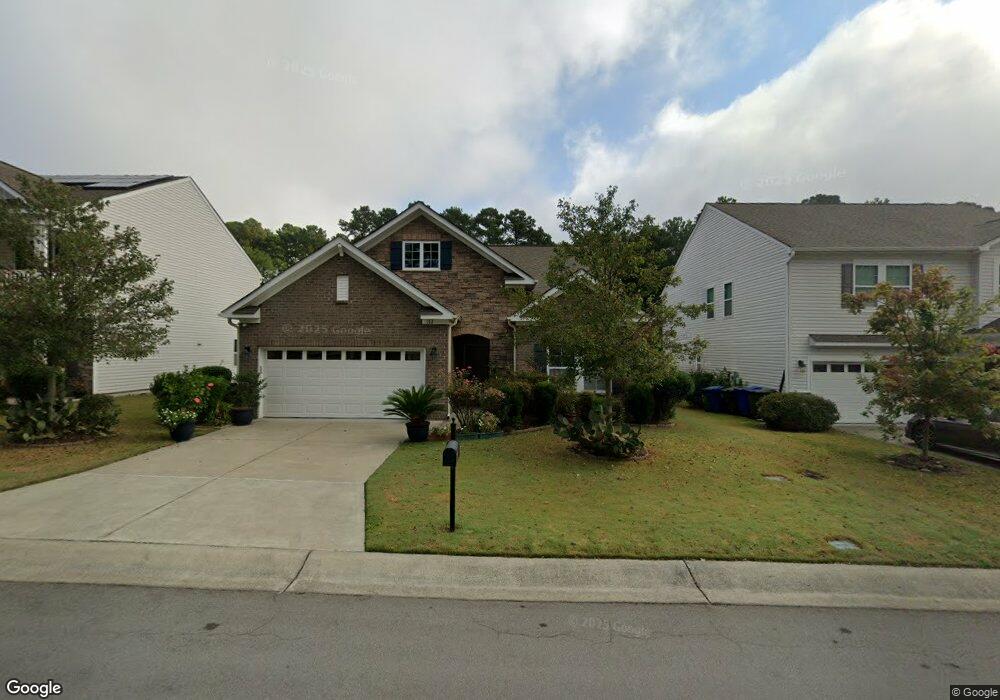
112 Foxborough Ln Durham, NC 27703
Eastern Durham NeighborhoodEstimated Value: $473,684 - $509,000
4
Beds
3
Baths
2,117
Sq Ft
$233/Sq Ft
Est. Value
About This Home
This home is located at 112 Foxborough Ln, Durham, NC 27703 and is currently estimated at $492,921, approximately $232 per square foot. 112 Foxborough Ln is a home located in Durham County with nearby schools including Spring Valley Elementary School, John W Neal Middle School, and Southern School of Energy & Sustainability.
Ownership History
Date
Name
Owned For
Owner Type
Purchase Details
Closed on
Sep 9, 2016
Sold by
Calatlantic Grp Inc
Bought by
Dejesus Franciso and Dejesus Anita
Current Estimated Value
Purchase Details
Closed on
Feb 12, 2016
Sold by
Gk Brightwood Lllp
Bought by
Calatlantic Grp Inc
Purchase Details
Closed on
Apr 20, 2010
Sold by
St Lawrence Homes Inc
Bought by
Rj Brightwood Llc
Create a Home Valuation Report for This Property
The Home Valuation Report is an in-depth analysis detailing your home's value as well as a comparison with similar homes in the area
Home Values in the Area
Average Home Value in this Area
Purchase History
| Date | Buyer | Sale Price | Title Company |
|---|---|---|---|
| Dejesus Franciso | $291,000 | -- | |
| Calatlantic Grp Inc | $708,000 | -- | |
| Rj Brightwood Llc | -- | None Available |
Source: Public Records
Tax History
| Year | Tax Paid | Tax Assessment Tax Assessment Total Assessment is a certain percentage of the fair market value that is determined by local assessors to be the total taxable value of land and additions on the property. | Land | Improvement |
|---|---|---|---|---|
| 2025 | $3,133 | $526,745 | $104,125 | $422,620 |
| 2024 | $3,818 | $291,452 | $53,595 | $237,857 |
| 2023 | $3,818 | $291,452 | $53,595 | $237,857 |
| 2022 | $3,730 | $291,452 | $53,595 | $237,857 |
| 2021 | $3,713 | $291,452 | $53,595 | $237,857 |
| 2020 | $3,625 | $291,452 | $53,595 | $237,857 |
| 2019 | $3,625 | $291,452 | $53,595 | $237,857 |
| 2018 | $3,138 | $231,312 | $47,640 | $183,672 |
| 2017 | $3,115 | $231,312 | $47,640 | $183,672 |
| 2016 | $620 | $47,640 | $47,640 | $0 |
| 2015 | $63 | $4,584 | $4,584 | $0 |
| 2014 | $63 | $4,584 | $4,584 | $0 |
Source: Public Records
Map
Nearby Homes
- 2208 Gilman St
- Landrum III Plan at Stella View - Summit Collection
- Mayflower III Plan at Stella View - Summit Collection
- Coleman Plan at Stella View - Ardmore Collection
- Tryon III Plan at Stella View - Summit Collection
- 108 Putters Ct
- 1204 Constellation Cir
- 1202 Constellation Cir
- 1200 Constellation Cir
- 1126 Constellation Cir
- 1009 Frisco Ct
- 807 Outlaw Ave
- 1114 Blackthorn Ln
- 807 Outlaw Ave Unit 19
- 1108 Constellation Cir
- 1114 Constellation Cir
- 1112 Constellation Cir
- 1050 Constellation Cir
- 1041 Constellation Cir
- 1035 Constellation Cir
- 114 Foxborough Ln
- 110 Foxborough Ln
- 116 Foxborough Ln
- 108 Foxborough Ln
- 111 Foxborough Ln
- 118 Foxborough Ln
- 113 Foxborough Ln
- 106 Foxborough Ln
- 109 Foxborough Ln
- 115 Foxborough Ln
- 122 Foxborough Ln
- 107 Foxborough Ln
- 117 Foxborough Ln
- 912 Poplar St
- 910 Poplar St
- 202 Foxborough Ln
- 914 Poplar St
- 105 Foxborough Ln
- 119 Foxborough Ln
- 121 Foxborough Ln
Your Personal Tour Guide
Ask me questions while you tour the home.