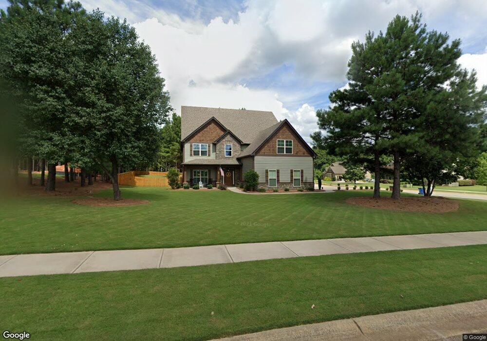
112 Kenmare Row Tyrone, GA 30290
Estimated Value: $775,756 - $891,000
About This Home
This home is located at 112 Kenmare Row, Tyrone, GA 30290 and is currently estimated at $818,189, approximately $197 per square foot. 112 Kenmare Row is a home located in Fayette County with nearby schools including Crabapple Lane Elementary School, Flat Rock Middle School, and Sandy Creek High School.
Ownership History
We collect this data history from publicly available records. To have your information removed, we recommend requesting removal directly through your county’s website.
Purchase Details
Home Financials for this Owner
Home Financials are based on the most recent Mortgage that was taken out on this home.Purchase Details
Home Financials for this Owner
Home Financials are based on the most recent Mortgage that was taken out on this home.Purchase Details
Home Values in the Area
Average Home Value in this Area
Purchase History
We collect this data history from publicly available records. To have your information removed, we recommend requesting removal directly through your county’s website.
| Date | Buyer | Sale Price | Title Company |
|---|---|---|---|
| $474,500 | -- | ||
| $409,900 | -- | ||
| $130,000 | -- |
Mortgage History
We collect this data history from publicly available records. To have your information removed, we recommend requesting removal directly through your county’s website.
| Date | Status | Borrower | Loan Amount |
|---|---|---|---|
| Open | $379,600 | ||
| Previous Owner | $327,920 |
Tax History
We collect this data history from publicly available records. To have your information removed, we recommend requesting removal directly through your county’s website.
| Year | Tax Paid | Tax Assessment Tax Assessment Total Assessment is a certain percentage of the fair market value that is determined by local assessors to be the total taxable value of land and additions on the property. | Land | Improvement |
|---|---|---|---|---|
| 2025 | $7,227 | $305,639 | $44,940 | $260,699 |
| 2024 | $7,037 | $285,644 | $42,000 | $243,644 |
| 2023 | $6,543 | $273,840 | $42,000 | $231,840 |
| 2022 | $5,388 | $238,640 | $42,000 | $196,640 |
| 2021 | $6,091 | $207,240 | $30,000 | $177,240 |
| 2020 | $6,056 | $196,400 | $30,000 | $166,400 |
| 2019 | $5,907 | $189,800 | $29,400 | $160,400 |
| 2018 | $5,832 | $183,000 | $30,000 | $153,000 |
| 2017 | $5,945 | $185,880 | $30,000 | $155,880 |
| 2016 | $5,335 | $163,440 | $22,800 | $140,640 |
| 2015 | $6,299 | $189,760 | $22,800 | $166,960 |
| 2014 | -- | $22,800 | $22,800 | $0 |
| 2013 | -- | $22,800 | $0 | $0 |
Map
- 113 Kenmare Row
- 137 Kenmare Row
- 110 Beresford Rd
- 135 Crimson Ridge
- 160 Kylemore Pass
- 190 Rockington Dr
- 101 Line Creek Way
- 240 Crestwood Rd
- 100 Clydesdale Ct
- 100 London Berry Ct
- 2080 Castle Lake Dr
- 80 Northwoods Rd
- 135 London Berry Ct
- 100 W Wind Ct
- 321 Cottonwood Cir
- 408 Cottonwood Cir
- 105 Brookgrove Ln
- 200 Chaparral Trace
- 115 Saint Andrews Walk
- 1103 Maybeck Way
- 112 Kenmare Row Unit 53
- 581 Mcdade St Unit 54
- 581 Mcdade St
- 149 Kenmare Row
- 119 Kenmare Row
- 114 Kenmare Row
- 588 Mcdade St Unit 27
- 588 Mcdade St
- 121 Kenmare Row Unit 30
- 121 Kenmare Row
- 583 Mcdade St
- 123 Kenmare Row Unit 29
- 123 Kenmare Row
- 125 Kenmare Row
- 125 Kenmare Row Unit 133
- 125 Kenmare Row Unit 134
- 110 Kenmare Row Unit 52
- 117 Kenmare Row Unit 32
- 127 Kenmare Row
- 127 Kenmare Row Unit 133
Ask me questions while you tour the home.