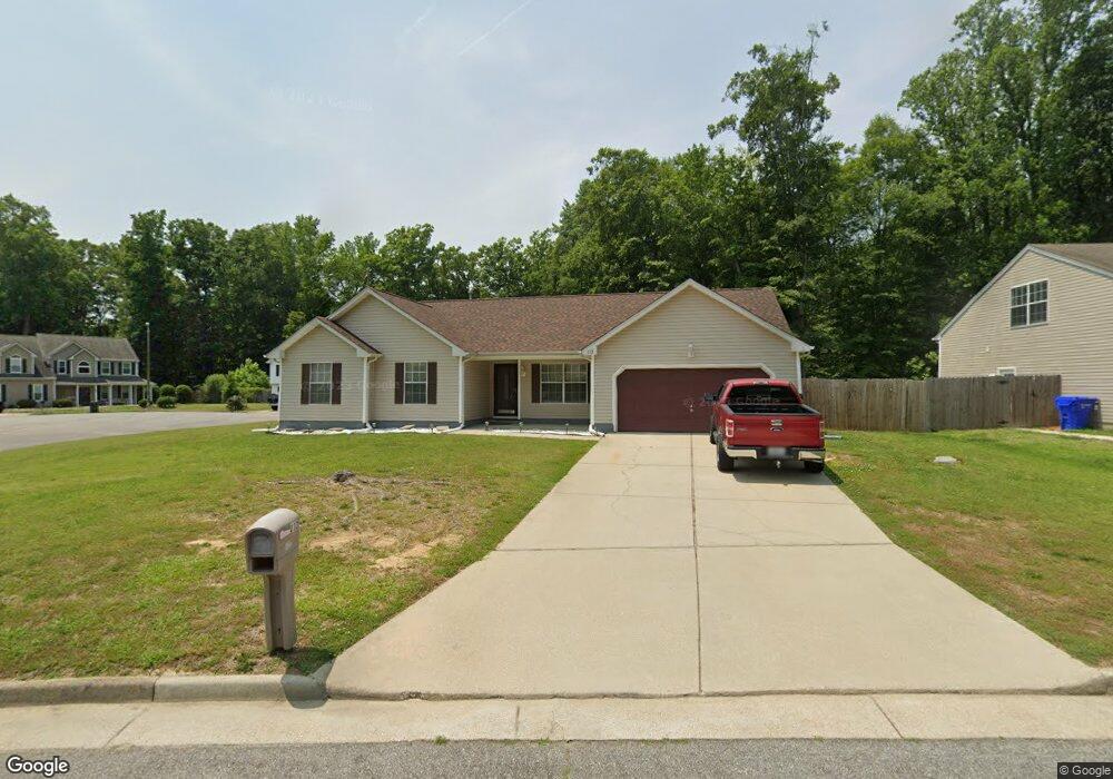
112 Misty Ridge Ln Suffolk, VA 23434
Holy Neck NeighborhoodEstimated Value: $365,079 - $376,000
3
Beds
2
Baths
1,629
Sq Ft
$228/Sq Ft
Est. Value
About This Home
This home is located at 112 Misty Ridge Ln, Suffolk, VA 23434 and is currently estimated at $370,770, approximately $227 per square foot. 112 Misty Ridge Ln is a home located in Suffolk City with nearby schools including Hillpoint Elementary School, King's Fork Middle School, and King's Fork High School.
Ownership History
Date
Name
Owned For
Owner Type
Purchase Details
Closed on
Sep 2, 2021
Sold by
Pedtke Allan W
Bought by
Mitchell Kenneth
Current Estimated Value
Home Financials for this Owner
Home Financials are based on the most recent Mortgage that was taken out on this home.
Original Mortgage
$305,000
Outstanding Balance
$278,343
Interest Rate
3%
Mortgage Type
VA
Estimated Equity
$92,427
Create a Home Valuation Report for This Property
The Home Valuation Report is an in-depth analysis detailing your home's value as well as a comparison with similar homes in the area
Home Values in the Area
Average Home Value in this Area
Purchase History
| Date | Buyer | Sale Price | Title Company |
|---|---|---|---|
| Mitchell Kenneth | $305,000 | Attorney |
Source: Public Records
Mortgage History
| Date | Status | Borrower | Loan Amount |
|---|---|---|---|
| Open | Mitchell Kenneth | $305,000 |
Source: Public Records
Tax History Compared to Growth
Tax History
| Year | Tax Paid | Tax Assessment Tax Assessment Total Assessment is a certain percentage of the fair market value that is determined by local assessors to be the total taxable value of land and additions on the property. | Land | Improvement |
|---|---|---|---|---|
| 2024 | $450 | $332,000 | $85,000 | $247,000 |
| 2023 | $393 | $323,700 | $85,000 | $238,700 |
| 2022 | $3,149 | $288,900 | $85,000 | $203,900 |
| 2021 | $2,703 | $243,500 | $65,500 | $178,000 |
| 2020 | $2,632 | $237,100 | $65,500 | $171,600 |
| 2019 | $2,632 | $237,100 | $65,500 | $171,600 |
| 2018 | $2,617 | $236,700 | $65,500 | $171,200 |
| 2017 | $2,533 | $236,700 | $65,500 | $171,200 |
| 2016 | $2,467 | $230,600 | $65,500 | $165,100 |
| 2015 | $1,197 | $218,300 | $65,500 | $152,800 |
| 2014 | $1,197 | $218,300 | $65,500 | $152,800 |
Source: Public Records
Map
Nearby Homes
- 310 Waterwood Way
- 220 Waterwood Way
- 210 Waterwood Way
- 200 Seasons Cir Unit 703
- 221 Waterwood Way
- 110 Jordan Ave
- 103 Jordan Ave
- 307 Shore Dr
- 311 Festival Ct
- 213 Fallawater Way
- 105 Dutchland Trail
- 1206 Peachtree Dr
- 1000 Regal Rd Unit A
- 236 Abingdon Cir
- 104 Benham Ct
- 106 Elmington Way
- 1100 Regal Rd Unit B
- 1301 Regal Rd Unit C
- 1301 Regal Rd Unit A
- 240 Fallawater Way
- 110 Misty Ridge Ln
- 302 Arbor Bluff Cove
- 108 Misty Ridge Ln
- 301 Arbor Bluff Cove
- 305 Arbor Bluff Cove
- 113 Misty Ridge Ln
- 303 Arbor Bluff Cove
- 111 Misty Ridge Ln
- 115 Misty Ridge Ln
- 109 Misty Ridge Ln
- 117 Misty Ridge Ln
- 116 Misty Ridge Ln
- 107 Misty Ridge Ln
- 105 Misty Ridge Ln
- 118 Misty Ridge Ln
- 128 Riverwood Trace
- 126 Riverwood Trace
- 309 Waterwood Way
- 130 Riverwood Trace
- 124 Riverwood Trace