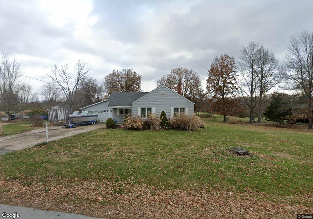
112 N Milspring Cir Godfrey, IL 62035
Estimated Value: $133,000 - $179,000
4
Beds
1
Bath
794
Sq Ft
$202/Sq Ft
Est. Value
About This Home
This home is located at 112 N Milspring Cir, Godfrey, IL 62035 and is currently estimated at $160,292, approximately $201 per square foot. 112 N Milspring Cir is a home located in Madison County with nearby schools including Lewis & Clark Elementary School, Alton Middle School, and Alton High School.
Ownership History
Date
Name
Owned For
Owner Type
Purchase Details
Closed on
Apr 9, 2012
Sold by
Brown Jeffrey P
Bought by
Nelson Ruth and Bertels Lisa A
Current Estimated Value
Purchase Details
Closed on
Jun 29, 2004
Sold by
Nelson Ruth and Nelson Clifford
Bought by
Nelson Ruth and Bertels Lisa A
Purchase Details
Closed on
Aug 29, 2003
Sold by
Cole Jeremy L and Cole Lori B
Bought by
Nelson Clifford and Nelson Ruth
Create a Home Valuation Report for This Property
The Home Valuation Report is an in-depth analysis detailing your home's value as well as a comparison with similar homes in the area
Home Values in the Area
Average Home Value in this Area
Purchase History
| Date | Buyer | Sale Price | Title Company |
|---|---|---|---|
| Nelson Ruth | -- | None Available | |
| Nelson Ruth | -- | -- | |
| Nelson Clifford | $88,000 | Community Title & Escrow |
Source: Public Records
Tax History Compared to Growth
Tax History
| Year | Tax Paid | Tax Assessment Tax Assessment Total Assessment is a certain percentage of the fair market value that is determined by local assessors to be the total taxable value of land and additions on the property. | Land | Improvement |
|---|---|---|---|---|
| 2024 | $3,482 | $51,650 | $16,270 | $35,380 |
| 2023 | $3,482 | $47,680 | $15,020 | $32,660 |
| 2022 | $3,326 | $43,610 | $13,740 | $29,870 |
| 2021 | $1,575 | $41,010 | $12,920 | $28,090 |
| 2020 | $1,582 | $40,120 | $12,640 | $27,480 |
| 2019 | $1,664 | $39,070 | $12,310 | $26,760 |
| 2018 | $1,664 | $37,410 | $11,790 | $25,620 |
| 2017 | $2,045 | $37,410 | $11,790 | $25,620 |
| 2016 | $1,986 | $37,410 | $11,790 | $25,620 |
| 2015 | $1,618 | $36,230 | $11,420 | $24,810 |
| 2014 | $1,618 | $36,230 | $11,420 | $24,810 |
| 2013 | $1,618 | $36,230 | $11,420 | $24,810 |
Source: Public Records
Map
Nearby Homes
- 5707 Humbert Rd
- 5667 Humbert Rd
- 5661 Humbert Rd
- 0 Humbert Rd Unit MIS25052876
- 123 Tolle Ln
- 421 Saint John Dr
- 00 Pine Ridge Lot#52 Dr
- 212 Pine Ridge Dr
- 223 Bachman Ln
- 5775 Roach Rd
- 4805 Wick Mor Dr
- 504 Elm St
- 709 Pardee Rd
- 709 Stamper Ln
- 607 Mulberry St
- 5310 Godfrey Rd Unit 12
- 5310 Godfrey Rd Unit 16
- 5310 Godfrey Rd Unit 2
- 5510 Lamotte Ln
- 4814 Azalea Place Unit 2
- 108 N Milspring Cir
- 200 N Milspring Cir
- 109 N Milspring Cir
- 5671 W Milspring Cir
- 202 N Milspring Cir
- 5672 W Milspring Cir
- 106 N Milspring Cir
- 5670 W Milspring Cir
- 204 N Milspring Cir
- 104 N Milspring Cir
- 5669 W Milspring Cir
- 205 N Milspring Cir
- 206 N Milspring Cir
- 5668 W Milspring Cir
- 5705 Humbert Rd
- 5674 E Milspring Cir
- 5667 W Milspring Cir
- 5711 Humbert Rd
- 102 N Milspring Cir
- 103 N Milspring Cir