

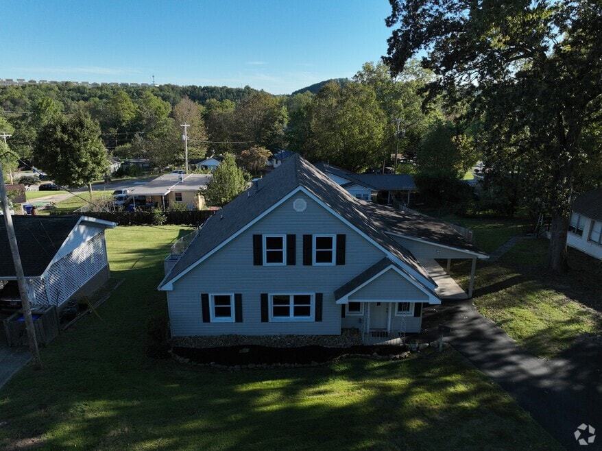


112 Nasson Ln Oak Ridge, TN 37830
Estimated payment $1,840/month
Total Views
94,271
4
Beds
2
Baths
2,064
Sq Ft
$157
Price per Sq Ft
Highlights
- City View
- Craftsman Architecture
- Fenced Yard
- Woodland Elementary School Rated A
- No HOA
- Cul-De-Sac
About This Home
Charming Opportunity at 112 Nasson Lane, Oak Ridge
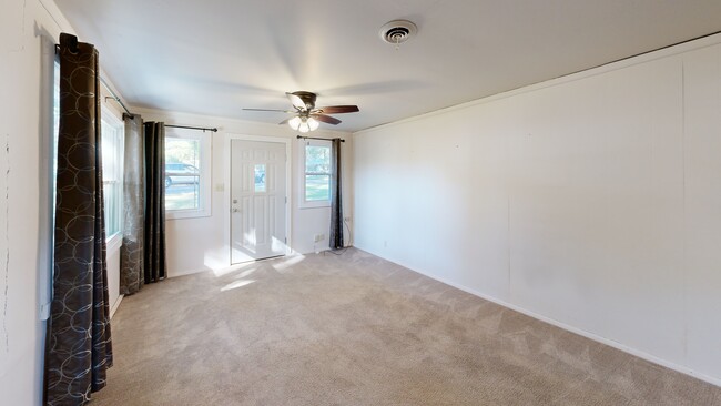
Discover the possibilities in this cozy 4-bedroom, 2-bath home in Oak Ridge. With classic bones and a welcoming layout, this property offers a canvas for your creative touch. Whether you're a first-time buyer, investor, or renovation enthusiast, you'll appreciate the potential to restore and personalize this space.
• Spacious rooms with natural light
• Generous fenced backyard & garden shed
• Attached 13' x 24' carport
• Conveniently located near:
- Woodland Elementary - 0.5 mile
-Jefferson Middle School - 2.4 miles
-Oak Ridge High School - 1.6 miles
-A.K. Bissell Park - 1.6 miles
-Melton Lake Greenway - 4.6 miles
- Walmart Supercenter - 0.7 miles
This home needs some TLC, but the charm is already there. Bring your vision and make 112 Nasson Lane your next project—or your forever home.
Call today to schedule a showing and explore the possibilities!
Home Details
Home Type
- Single Family
Est. Annual Taxes
- $1,619
Year Built
- Built in 1948
Lot Details
- 8,712 Sq Ft Lot
- Cul-De-Sac
- Fenced Yard
Home Design
- Craftsman Architecture
- Traditional Architecture
- Block Foundation
- Frame Construction
- Cement Siding
- Vinyl Siding
Interior Spaces
- 2,064 Sq Ft Home
- Combination Dining and Living Room
- City Views
- Dryer
Kitchen
- Range
- Microwave
- Dishwasher
Flooring
- Carpet
- Tile
- Vinyl
Bedrooms and Bathrooms
- 4 Bedrooms
- 2 Full Bathrooms
Parking
- 2 Carport Spaces
- On-Street Parking
Outdoor Features
- Patio
- Outdoor Storage
Schools
- Woodland Elementary School
- Jefferson Middle School
- Oak Ridge High School
Utilities
- Central Heating and Cooling System
- Internet Available
Community Details
- No Home Owners Association
Listing and Financial Details
- Assessor Parcel Number 100P C 039.00
- Tax Block 0K14
3D Interior and Exterior Tours
Floorplans
Map
Create a Home Valuation Report for This Property
The Home Valuation Report is an in-depth analysis detailing your home's value as well as a comparison with similar homes in the area
Home Values in the Area
Average Home Value in this Area
Tax History
| Year | Tax Paid | Tax Assessment Tax Assessment Total Assessment is a certain percentage of the fair market value that is determined by local assessors to be the total taxable value of land and additions on the property. | Land | Improvement |
|---|---|---|---|---|
| 2024 | $834 | $33,950 | $5,000 | $28,950 |
| 2023 | $834 | $33,950 | $0 | $0 |
| 2022 | $1,619 | $33,950 | $5,000 | $28,950 |
| 2021 | $1,619 | $33,950 | $5,000 | $28,950 |
| 2020 | $1,394 | $33,950 | $5,000 | $28,950 |
| 2019 | $1,427 | $27,150 | $4,000 | $23,150 |
| 2018 | $1,394 | $27,150 | $4,000 | $23,150 |
| 2017 | $1,388 | $27,150 | $4,000 | $23,150 |
| 2016 | $1,398 | $27,150 | $4,000 | $23,150 |
| 2015 | -- | $27,325 | $4,000 | $23,325 |
| 2014 | -- | $27,325 | $4,000 | $23,325 |
| 2013 | -- | $26,300 | $0 | $0 |
Source: Public Records
Property History
| Date | Event | Price | List to Sale | Price per Sq Ft |
|---|---|---|---|---|
| 10/10/2025 10/10/25 | For Sale | $325,000 | -- | $157 / Sq Ft |
Source: East Tennessee REALTORS® MLS
Purchase History
| Date | Type | Sale Price | Title Company |
|---|---|---|---|
| Deed | -- | -- | |
| Deed | -- | -- |
Source: Public Records
Mortgage History
| Date | Status | Loan Amount | Loan Type |
|---|---|---|---|
| Closed | $107,100 | No Value Available |
Source: Public Records
About the Listing Agent
Originally from the picturesque state of Vermont, Karen moved to beautiful East Tennessee in 2016, bringing with her a lifelong passion for real estate. After a fulfilling 34-year career in physical therapy, Karen and her partner Neil decided it was time for a new adventure. In 2022, they embraced their dream and became realtors in the stunning landscapes of East Tennessee.
Together, they formed Agents 24-7, a name that reflects their unwavering commitment and dedication to their
Karen's Other Listings
Source: East Tennessee REALTORS® MLS
MLS Number: 1318266
APN: 100P-C-039.00
Disclaimer: Certain information contained herein is derived from information provided by parties other than Homes.com. All information provided is deemed reliable, but is not guaranteed to be accurate and should be independently verified.
![]() IDX information is provided exclusively for personal, non-commercial use, and may not be used for any purpose other than to identify prospective properties consumers may be interested in purchasing. Information is deemed reliable but not guaranteed.
IDX information is provided exclusively for personal, non-commercial use, and may not be used for any purpose other than to identify prospective properties consumers may be interested in purchasing. Information is deemed reliable but not guaranteed.
Listing Information presented by local MLS brokerage: Ten-X, LLC dba Homes.com, local broker - Arlene Richardson - 888-952-6393.
Nearby Homes
- 109 Nasson Ln
- 191 Manhattan Ave
- 207 Manhattan Ave
- 101 Hendrix Dr
- 100 Harper Ln
- 121 Goucher Cir
- 116 W Gettysburg Ave
- 113 High Point Ln
- 110 Wolf Creek Way
- 103 Wolf Creek Way
- 160 High Point Ln
- 162 High Point Ln
- 105 Hampshire Cir
- 118 Venus Rd
- 107 Crystal Cove Ln
- 100 Viola Rd
- 109 Eastridge Dr
- 106 Paoli Ln
- 109 E Pasadena Rd
- 172 Crossroads Blvd
- 100 Lisa's Way
- 105 Inn Ln
- 790 Emory Valley Rd
- 300 S Tulane Ave
- 301 Briarcliff Ave
- 112 Bennett Ln
- 82 E Tennessee Ave
- 157 Wade Ln
- 241 Waddell Cir
- 208 E Tennessee Ave
- 239 Waddell Cir
- 239 Waddell Cir
- 239 Waddell Cir
- 355 W Outer Dr
- 379 W Outer Dr Unit 385
- 100 Teejay Dr
- 307 Florida Ave
- 101 Virginia Rd
- 318 E Fairview Rd Unit 318
- 150 Outer Dr