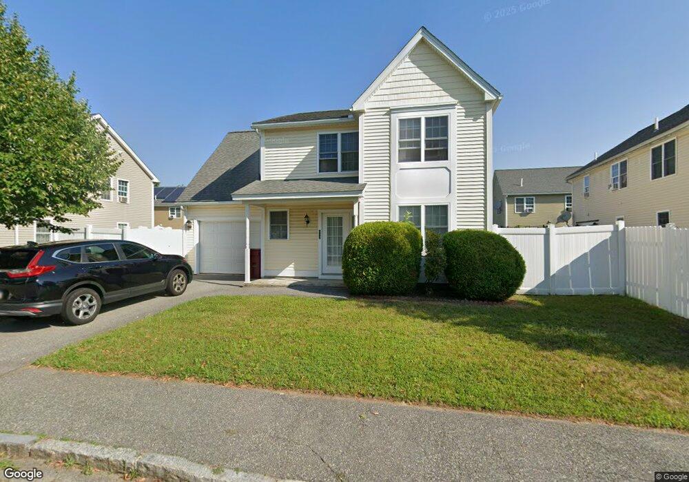
112 Rivers Edge Rd Lowell, MA 01852
Sacred Heart NeighborhoodEstimated Value: $471,000 - $537,000
3
Beds
2
Baths
1,344
Sq Ft
$370/Sq Ft
Est. Value
About This Home
This home is located at 112 Rivers Edge Rd, Lowell, MA 01852 and is currently estimated at $497,792, approximately $370 per square foot. 112 Rivers Edge Rd is a home located in Middlesex County with nearby schools including Abraham Lincoln Elementary School, Moody Elementary School, and Greenhalge Elementary School.
Ownership History
Date
Name
Owned For
Owner Type
Purchase Details
Closed on
Jan 11, 2008
Sold by
Residents First Dev Co
Bought by
Zou Jingyi and Yang Ping
Current Estimated Value
Home Financials for this Owner
Home Financials are based on the most recent Mortgage that was taken out on this home.
Original Mortgage
$100,000
Outstanding Balance
$63,286
Interest Rate
6.21%
Mortgage Type
Purchase Money Mortgage
Estimated Equity
$434,506
Create a Home Valuation Report for This Property
The Home Valuation Report is an in-depth analysis detailing your home's value as well as a comparison with similar homes in the area
Home Values in the Area
Average Home Value in this Area
Purchase History
| Date | Buyer | Sale Price | Title Company |
|---|---|---|---|
| Zou Jingyi | $259,900 | -- | |
| Zou Jingyi | $259,900 | -- |
Source: Public Records
Mortgage History
| Date | Status | Borrower | Loan Amount |
|---|---|---|---|
| Open | Zou Jingyi | $100,000 | |
| Closed | Zou Jingyi | $100,000 |
Source: Public Records
Tax History
| Year | Tax Paid | Tax Assessment Tax Assessment Total Assessment is a certain percentage of the fair market value that is determined by local assessors to be the total taxable value of land and additions on the property. | Land | Improvement |
|---|---|---|---|---|
| 2025 | $4,812 | $419,200 | $140,500 | $278,700 |
| 2024 | $4,877 | $409,500 | $131,300 | $278,200 |
| 2023 | $4,956 | $399,000 | $114,200 | $284,800 |
| 2022 | $4,519 | $356,100 | $103,800 | $252,300 |
| 2021 | $4,568 | $339,400 | $90,300 | $249,100 |
| 2020 | $3,655 | $273,600 | $85,900 | $187,700 |
| 2019 | $3,506 | $249,700 | $79,500 | $170,200 |
| 2018 | $3,505 | $243,600 | $75,700 | $167,900 |
| 2017 | $3,426 | $229,600 | $68,800 | $160,800 |
| 2016 | $3,376 | $222,700 | $60,100 | $162,600 |
| 2015 | $3,206 | $207,100 | $60,100 | $147,000 |
| 2013 | $2,997 | $199,700 | $67,200 | $132,500 |
Source: Public Records
Map
Nearby Homes
- 1514 Gorham St Unit 4
- 1400 Gorham St Unit 42
- 1400 Gorham St Unit 32
- 1400 Gorham St Unit 46
- 74 Carlisle St
- 7 Gorham St Unit 54
- 7 Gorham St Unit 36
- 29 Gorham St
- 53 Gorham St
- 106 Lundberg St Unit 6
- 20 Woodland Dr Unit 330
- 20 Woodland Dr Unit 379
- 20 Woodland Dr Unit 376
- 80 Swan St Unit 223
- 14 Warnock St
- 18 Clancy St
- 1204 Lawrence St
- 36 Crowley St
- 4 Thomas William Way
- 34 Manning Rd
- 106 Rivers Edge Rd Unit 108
- 77 Nelson Ave Unit 79
- 41 Murray Ln Unit 43
- 31 Murray Ln
- 23 Murray Ln
- 105 Rivers Edge Rd
- 3 Murray Ln
- 15 Murray Ln
- 93 Nelson Ave
- 137 Adie Way
- 97 Rivers Edge Rd
- 59 Nelson Ave
- 36 Murray Ln
- 140 Adie Way
- 28 Murray Ln Unit 30
- 10 Ecklund Dr
- 24 Murray Ln
- 133 Adie Way
- 62 Nelson Ave
- 9 Adie Way
Your Personal Tour Guide
Ask me questions while you tour the home.