Estimated Value: $129,000 - $149,000
4
Beds
2
Baths
1,896
Sq Ft
$74/Sq Ft
Est. Value
About This Home
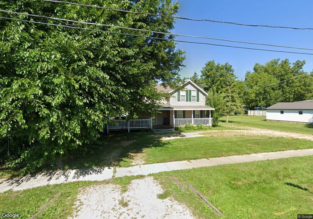
This home is located at 112 S Davis Ave, Amboy, IL 61310 and is currently estimated at $141,043, approximately $74 per square foot. 112 S Davis Ave is a home located in Lee County with nearby schools including Amboy Central Elementary School, Amboy Junior High School, and Amboy High School.
Ownership History
Date
Name
Owned For
Owner Type
Purchase Details
Closed on
Oct 27, 2006
Sold by
Craig James E
Bought by
Watley John M and Watley Kimberly
Current Estimated Value
Home Financials for this Owner
Home Financials are based on the most recent Mortgage that was taken out on this home.
Original Mortgage
$71,400
Outstanding Balance
$41,753
Interest Rate
6.38%
Mortgage Type
New Conventional
Estimated Equity
$99,290
Purchase Details
Closed on
Apr 25, 2006
Sold by
Child Dennis L and Child Karla K
Bought by
Craig James E
Purchase Details
Closed on
Feb 9, 2006
Sold by
Selden Don Marie
Bought by
Craig James E
Create a Home Valuation Report for This Property
The Home Valuation Report is an in-depth analysis detailing your home's value as well as a comparison with similar homes in the area
Home Values in the Area
Average Home Value in this Area
Purchase History
| Date | Buyer | Sale Price | Title Company |
|---|---|---|---|
| Watley John M | $68,000 | None Available | |
| Craig James E | $35,000 | None Available | |
| Craig James E | -- | None Available |
Source: Public Records
Mortgage History
| Date | Status | Borrower | Loan Amount |
|---|---|---|---|
| Open | Watley John M | $71,400 |
Source: Public Records
Tax History
| Year | Tax Paid | Tax Assessment Tax Assessment Total Assessment is a certain percentage of the fair market value that is determined by local assessors to be the total taxable value of land and additions on the property. | Land | Improvement |
|---|---|---|---|---|
| 2024 | $2,350 | $33,494 | $5,433 | $28,061 |
| 2023 | $1,927 | $29,125 | $4,724 | $24,401 |
| 2022 | $1,927 | $26,720 | $4,334 | $22,386 |
| 2021 | $2,035 | $27,777 | $4,176 | $23,601 |
| 2020 | $1,997 | $26,968 | $4,054 | $22,914 |
| 2019 | $1,991 | $26,183 | $3,936 | $22,247 |
| 2018 | $1,893 | $24,937 | $3,749 | $21,188 |
| 2017 | $2,219 | $30,393 | $6,019 | $24,374 |
| 2016 | $2,204 | $30,393 | $6,019 | $24,374 |
| 2015 | $2,191 | $30,393 | $6,019 | $24,374 |
| 2014 | $2,363 | $30,393 | $6,019 | $24,374 |
| 2013 | $21 | $31,206 | $4,322 | $26,884 |
Source: Public Records
Map
Nearby Homes
- 206 S Boyd Ave
- 129 W Main St
- 1 E Main St
- 133 N East Ave
- 222 N Davis Ave
- 1801 Lee Center Rd
- 13/93 Woodhaven Dr
- 2/141&142 Woodhaven Dr
- 17/100 Woodhaven Dr
- 8/110 Woodhaven Dr
- 2/131 Woodhaven Dr
- 4/2 Woodhaven Dr
- 28/38 Woodhaven Dr
- 2/292 Woodhaven Dr
- 9/46 Woodhaven Dr
- 5/356 Woodhaven Dr E
- 21/197 Woodhaven Dr E
- 13/86 Woodhaven Dr E
- 4/211 Woodhaven Dr E
- 4/86 Woodhaven Dr E
- 116 S Davis Ave
- 105 S Davis Ave
- 106 S Davis Ave
- 121 S Boyd Ave
- 126 S Davis Ave
- 130 S Davis Ave
- 123 W Pearl St
- 139 W Pleasant St
- 201 S Boyd Ave
- 126 S Boyd Ave
- 24 S Davis Ave
- 23 S Davis Ave
- 205 S Boyd Ave
- 205 S Boyd Ave Unit 3
- 205 S Boyd Ave Unit 1
- 97 S Boyd Ave
- 134 S Davis Ave
- 134 S Davis Ave
- 133 W Pleasant St
- 210 W Pearl St
Your Personal Tour Guide
Ask me questions while you tour the home.