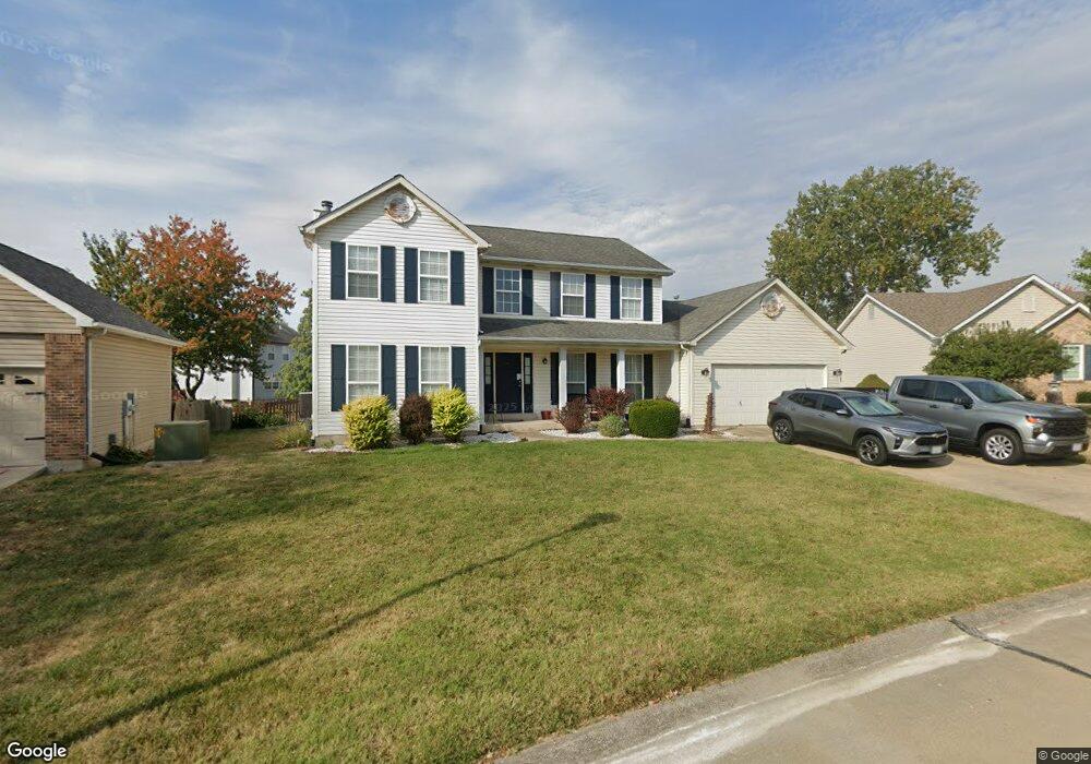
112 Spangle Way Ct O Fallon, MO 63366
Estimated Value: $415,606 - $455,000
4
Beds
3
Baths
2,554
Sq Ft
$170/Sq Ft
Est. Value
About This Home
This home is located at 112 Spangle Way Ct, O Fallon, MO 63366 and is currently estimated at $434,152, approximately $169 per square foot. 112 Spangle Way Ct is a home located in St. Charles County with nearby schools including Rock Creek Elementary School, Fort Zumwalt West Middle School, and Fort Zumwalt West High School.
Ownership History
Date
Name
Owned For
Owner Type
Purchase Details
Closed on
Mar 23, 2004
Sold by
Bibb Christopher Allen
Bought by
Revocab Bibb Christopher Allen and Revocab Christopher Allen Bibb
Current Estimated Value
Purchase Details
Closed on
Jul 2, 2001
Sold by
Bibb Ana M
Bought by
Bibb Christopher A
Home Financials for this Owner
Home Financials are based on the most recent Mortgage that was taken out on this home.
Original Mortgage
$144,000
Interest Rate
7.2%
Mortgage Type
Balloon
Create a Home Valuation Report for This Property
The Home Valuation Report is an in-depth analysis detailing your home's value as well as a comparison with similar homes in the area
Home Values in the Area
Average Home Value in this Area
Purchase History
| Date | Buyer | Sale Price | Title Company |
|---|---|---|---|
| Revocab Bibb Christopher Allen | -- | -- | |
| Bibb Christopher A | -- | -- |
Source: Public Records
Mortgage History
| Date | Status | Borrower | Loan Amount |
|---|---|---|---|
| Closed | Bibb Christopher A | $144,000 |
Source: Public Records
Tax History
| Year | Tax Paid | Tax Assessment Tax Assessment Total Assessment is a certain percentage of the fair market value that is determined by local assessors to be the total taxable value of land and additions on the property. | Land | Improvement |
|---|---|---|---|---|
| 2025 | $4,234 | $70,930 | -- | -- |
| 2023 | $4,236 | $64,063 | $0 | $0 |
| 2022 | $4,364 | $61,462 | $0 | $0 |
| 2021 | $4,367 | $61,462 | $0 | $0 |
| 2020 | $3,747 | $51,011 | $0 | $0 |
| 2019 | $3,756 | $51,011 | $0 | $0 |
| 2018 | $3,536 | $45,843 | $0 | $0 |
| 2017 | $3,494 | $45,843 | $0 | $0 |
| 2016 | $3,172 | $41,446 | $0 | $0 |
| 2015 | $2,949 | $41,446 | $0 | $0 |
| 2014 | $2,796 | $38,644 | $0 | $0 |
Source: Public Records
Map
Nearby Homes
- 14 Spangle Way Dr
- 20 Cherokee Sunset Ct Ct
- 109 Sterling Crossing Dr
- 3 Pinehurst Forest Ct
- 1455 Norwood Hills Dr
- 1234 Pinehurst Club Ct
- 2325 Sundance Dr
- 8 Winter Forest Ct
- 962 Midpoint Dr
- 10 Southern Hills Ct
- 1117 Turtle Creek Dr
- 11 Southern Hills Ct
- 217 Roaring River Dr
- 140 Weatherby Landing Dr
- 76 Brook Hollow Ct
- 6 Sage Meadows Ct
- 604 Sunward Dr
- 128 Royal Troon Dr
- New Build Berkshire II "D" @ Inverness
- New Build Berkshire "A" @ Inverness
- 110 Spangle Way Ct
- 114 Spangle Way Ct
- 5 Town Cryer Ct
- 1418 Presidents Landing Dr
- 1424 Presidents Landing Dr
- 7 Town Cryer Ct
- 1412 Presidents Landing Dr
- 108 Spangle Way Ct
- 116 Spangle Way Ct
- 113 Spangle Way Ct
- 3 Town Cryer Ct
- 1406 Presidents Landing Dr
- 117 Spangle Way Ct
- 106 Spangle Way Ct
- 6 Town Cryer Ct
- 118 Spangle Way Ct
- 119 Spangle Way Ct
- 740 Fife And Drum Dr
- 1400 Presidents Landing Dr
- 4 Town Cryer Ct
Your Personal Tour Guide
Ask me questions while you tour the home.