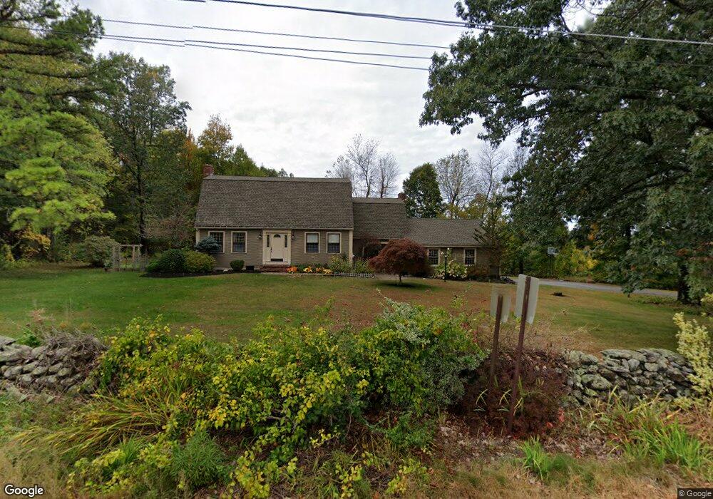
112 Tuttle Rd Sterling, MA 01564
Estimated Value: $609,861 - $702,000
4
Beds
3
Baths
2,312
Sq Ft
$279/Sq Ft
Est. Value
About This Home
This home is located at 112 Tuttle Rd, Sterling, MA 01564 and is currently estimated at $644,465, approximately $278 per square foot. 112 Tuttle Rd is a home located in Worcester County with nearby schools including Wachusett Regional High School.
Ownership History
Date
Name
Owned For
Owner Type
Purchase Details
Closed on
Jan 10, 2008
Sold by
Meunier Deborah Ann and Grinkis Matthew
Bought by
Meunier Deborah Ann
Current Estimated Value
Purchase Details
Closed on
Jun 15, 2005
Sold by
Meunier Jane E and Meunier Ralph E
Bought by
Meunier Deborah Ann and Grinkis Matthew
Home Financials for this Owner
Home Financials are based on the most recent Mortgage that was taken out on this home.
Original Mortgage
$210,000
Interest Rate
5.78%
Mortgage Type
Purchase Money Mortgage
Create a Home Valuation Report for This Property
The Home Valuation Report is an in-depth analysis detailing your home's value as well as a comparison with similar homes in the area
Home Values in the Area
Average Home Value in this Area
Purchase History
| Date | Buyer | Sale Price | Title Company |
|---|---|---|---|
| Meunier Deborah Ann | -- | -- | |
| Meunier Deborah Ann | $450,000 | -- |
Source: Public Records
Mortgage History
| Date | Status | Borrower | Loan Amount |
|---|---|---|---|
| Previous Owner | Meunier Deborah Ann | $210,000 |
Source: Public Records
Tax History
| Year | Tax Paid | Tax Assessment Tax Assessment Total Assessment is a certain percentage of the fair market value that is determined by local assessors to be the total taxable value of land and additions on the property. | Land | Improvement |
|---|---|---|---|---|
| 2025 | $7,221 | $560,600 | $155,800 | $404,800 |
| 2024 | $7,045 | $529,300 | $150,600 | $378,700 |
| 2023 | $6,654 | $465,300 | $142,800 | $322,500 |
| 2022 | $6,062 | $397,500 | $132,200 | $265,300 |
| 2021 | $6,127 | $370,900 | $129,800 | $241,100 |
| 2020 | $6,406 | $381,100 | $141,600 | $239,500 |
| 2019 | $5,537 | $357,400 | $141,600 | $215,800 |
| 2018 | $27,151 | $341,200 | $129,900 | $211,300 |
| 2017 | $5,853 | $324,600 | $119,200 | $205,400 |
| 2016 | $5,776 | $315,100 | $119,200 | $195,900 |
| 2015 | $5,778 | $334,200 | $131,400 | $202,800 |
| 2014 | $5,565 | $328,700 | $131,400 | $197,300 |
Source: Public Records
Map
Nearby Homes
- 90 Tuttle Rd
- 134 Leominster Rd
- 6A Patriots Way Unit 37
- 5 Pine Woods Ln
- 45 Neylon St
- 779 Willard St
- 96 Clinton Rd
- 2 Turtle Ln Unit 2
- 103 Keeneland Cir
- 121 &125 Flanagan Hill Rd
- 675 Willard St
- 23 Lantern Ln
- 4 Jewett Rd Unit B
- 4 Jewett Rd Unit A
- 40 Biscayne St
- 386 Redemption Rock Trail
- 193 Bayberry Hill Ln
- 186 Justice Hill Rd Unit Oakmont
- 186 Justice Hill Rd Unit Mod Farm
- 223 Worcester Rd
Your Personal Tour Guide
Ask me questions while you tour the home.