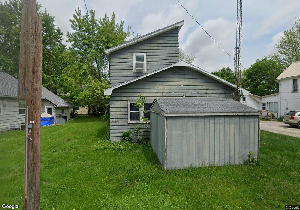
112 W Harmon St Oakwood, OH 45873
Estimated Value: $76,697 - $149,000
3
Beds
1
Bath
1,726
Sq Ft
$65/Sq Ft
Est. Value
About This Home
This home is located at 112 W Harmon St, Oakwood, OH 45873 and is currently estimated at $112,924, approximately $65 per square foot. 112 W Harmon St is a home with nearby schools including Paulding High School.
Ownership History
Date
Name
Owned For
Owner Type
Purchase Details
Closed on
Sep 5, 2007
Sold by
Federal Home Loan Mortgage Corporation
Bought by
Dotson Michael T
Current Estimated Value
Purchase Details
Closed on
Mar 28, 2007
Sold by
Kohart Scott A and Chase Home Finance Llc
Bought by
Federal Home Loan Mortgage Corporation
Purchase Details
Closed on
May 1, 2006
Sold by
Kohart Christine A
Bought by
Kohart Scott A
Purchase Details
Closed on
Oct 7, 2003
Sold by
Herr Thomas J
Bought by
Dotson Michael T
Purchase Details
Closed on
Jan 1, 1990
Bought by
Dotson Michael T
Create a Home Valuation Report for This Property
The Home Valuation Report is an in-depth analysis detailing your home's value as well as a comparison with similar homes in the area
Home Values in the Area
Average Home Value in this Area
Purchase History
| Date | Buyer | Sale Price | Title Company |
|---|---|---|---|
| Dotson Michael T | -- | None Available | |
| Federal Home Loan Mortgage Corporation | $20,000 | None Available | |
| Kohart Scott A | -- | None Available | |
| Dotson Michael T | $30,000 | -- | |
| Dotson Michael T | -- | -- |
Source: Public Records
Tax History Compared to Growth
Tax History
| Year | Tax Paid | Tax Assessment Tax Assessment Total Assessment is a certain percentage of the fair market value that is determined by local assessors to be the total taxable value of land and additions on the property. | Land | Improvement |
|---|---|---|---|---|
| 2024 | $3,272 | $17,020 | $1,510 | $15,510 |
| 2023 | $3,272 | $17,020 | $1,510 | $15,510 |
| 2022 | $761 | $17,020 | $1,510 | $15,510 |
| 2021 | $649 | $13,310 | $1,440 | $11,870 |
| 2020 | $665 | $13,310 | $1,440 | $11,870 |
| 2019 | $670 | $11,520 | $1,440 | $10,080 |
| 2018 | $597 | $11,520 | $1,440 | $10,080 |
| 2017 | $612 | $11,520 | $1,440 | $10,080 |
| 2016 | $597 | $11,520 | $1,440 | $10,080 |
| 2015 | $612 | $11,980 | $1,440 | $10,540 |
| 2014 | $586 | $11,980 | $1,440 | $10,540 |
| 2013 | $658 | $12,540 | $1,440 | $11,100 |
Source: Public Records
Map
Nearby Homes
- 104 Jackson St
- 307 Main St
- 23479 Road 104
- 9150 State Route 66
- 23423 Township Rd E
- 12288 Road 179
- 0 Road E
- 301 W Forrest St
- 402 S 5th St
- 202 S 5th St
- 305 S Main St
- 406 N Main St
- 204 E Sugar St
- 203 E Ash St
- 24220 County Road 196
- 14326 Road 171
- 14354 Road 171
- 14363 County Road 171
- 301 E Wayne St
- 100 N Maple St