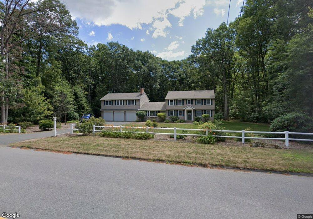
112 W Mountain Rd West Simsbury, CT 06092
Estimated Value: $594,000 - $696,000
4
Beds
3
Baths
2,292
Sq Ft
$276/Sq Ft
Est. Value
About This Home
This home is located at 112 W Mountain Rd, West Simsbury, CT 06092 and is currently estimated at $632,441, approximately $275 per square foot. 112 W Mountain Rd is a home located in Hartford County with nearby schools including Tootin' Hills School, Henry James Memorial School, and Simsbury High School.
Ownership History
Date
Name
Owned For
Owner Type
Purchase Details
Closed on
Jun 29, 2021
Sold by
Dumont Melissa H
Bought by
Dumont Pierre P
Current Estimated Value
Purchase Details
Closed on
May 1, 2003
Sold by
Vernali Russell V and Vernali Diane M
Bought by
Dumont Pierre P and Dumont Melissa H
Home Financials for this Owner
Home Financials are based on the most recent Mortgage that was taken out on this home.
Original Mortgage
$252,000
Interest Rate
5.82%
Purchase Details
Closed on
Mar 2, 1992
Sold by
Visonic Ltd
Bought by
Vernali Russell and Vernali Diane
Purchase Details
Closed on
Jul 10, 1990
Sold by
Gwinnell Harry
Bought by
Visonic Ltd
Create a Home Valuation Report for This Property
The Home Valuation Report is an in-depth analysis detailing your home's value as well as a comparison with similar homes in the area
Home Values in the Area
Average Home Value in this Area
Purchase History
| Date | Buyer | Sale Price | Title Company |
|---|---|---|---|
| Dumont Pierre P | -- | None Available | |
| Dumont Pierre P | $315,000 | -- | |
| Vernali Russell | $205,000 | -- | |
| Visonic Ltd | $210,000 | -- |
Source: Public Records
Mortgage History
| Date | Status | Borrower | Loan Amount |
|---|---|---|---|
| Previous Owner | Visonic Ltd | $191,200 | |
| Previous Owner | Visonic Ltd | $252,000 | |
| Previous Owner | Visonic Ltd | $150,000 | |
| Previous Owner | Visonic Ltd | $162,000 |
Source: Public Records
Tax History Compared to Growth
Tax History
| Year | Tax Paid | Tax Assessment Tax Assessment Total Assessment is a certain percentage of the fair market value that is determined by local assessors to be the total taxable value of land and additions on the property. | Land | Improvement |
|---|---|---|---|---|
| 2025 | $10,715 | $313,670 | $87,500 | $226,170 |
| 2024 | $10,448 | $313,670 | $87,500 | $226,170 |
| 2023 | $9,981 | $313,670 | $87,500 | $226,170 |
| 2022 | $9,550 | $247,220 | $79,380 | $167,840 |
| 2021 | $9,550 | $247,220 | $79,380 | $167,840 |
| 2020 | $9,169 | $247,220 | $79,380 | $167,840 |
| 2019 | $9,226 | $247,220 | $79,380 | $167,840 |
| 2018 | $9,293 | $247,220 | $79,380 | $167,840 |
| 2017 | $9,039 | $233,200 | $79,380 | $153,820 |
| 2016 | $8,656 | $233,200 | $79,380 | $153,820 |
| 2015 | $8,656 | $233,200 | $79,380 | $153,820 |
| 2014 | $8,661 | $233,200 | $79,380 | $153,820 |
Source: Public Records
Map
Nearby Homes
- 10 Sachems Trail
- 8 Quorn Hunt Rd
- 143 N Mountain Rd
- 23 Red Fox Run
- 18 Meadowlark Rd
- 15 Red Fox Run
- 21 Christmas Tree Hill
- 47 Long View Dr
- 121 Gracey Rd
- 269 W Mountain Rd
- 301 Bushy Hill Rd
- 42 Garrett Rd
- 265 E Hill Rd
- 395 Bushy Hill Rd
- 6 Highwood Rd
- 391 Cherry Brook Rd
- 16 Stratton Forest Way
- 152 E Hill Rd
- 8 Crane Place
- 10 Mountain Spring Rd
- 116 W Mountain Rd
- 7 Nimrod Rd
- 111 W Mountain Rd
- 115 W Mountain Rd
- 107 W Mountain Rd
- 122 W Mountain Rd
- 11 Nimrod Rd
- 121 W Mountain Rd
- 126 W Mountain Rd
- 102 W Mountain Rd
- 123 W Mountain Rd
- 8 Nimrod Rd
- 67 Quorn Hunt Rd
- 2 Sachems Trail
- 31 Tootin Hill Rd
- 31 Tootin Hill Rd Unit RD
- 4 Sachems Trail
- 129 W Mountain Rd
- 6 Sachems Trail
- 63 Quorn Hunt Rd