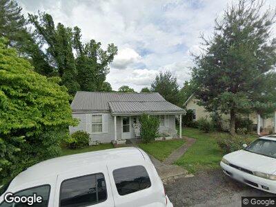
1120 Browns Alley Bristol, VA 24201
Estimated Value: $74,000 - $135,000
2
Beds
1
Bath
752
Sq Ft
$143/Sq Ft
Est. Value
About This Home
This home is located at 1120 Browns Alley, Bristol, VA 24201 and is currently estimated at $107,901, approximately $143 per square foot. 1120 Browns Alley is a home located in Bristol City with nearby schools including Virginia High School, Brookside Academy, and St. Anne Catholic School.
Ownership History
Date
Name
Owned For
Owner Type
Purchase Details
Closed on
Jan 2, 2024
Sold by
Hodge Hubert Scott
Bought by
Lanier Amber
Current Estimated Value
Home Financials for this Owner
Home Financials are based on the most recent Mortgage that was taken out on this home.
Original Mortgage
$112,917
Outstanding Balance
$111,998
Interest Rate
6.61%
Mortgage Type
FHA
Estimated Equity
-$2,993
Purchase Details
Closed on
Nov 9, 2018
Sold by
Reeves Dunham Hodge Patricia
Bought by
Hodge Hubert Scott
Create a Home Valuation Report for This Property
The Home Valuation Report is an in-depth analysis detailing your home's value as well as a comparison with similar homes in the area
Home Values in the Area
Average Home Value in this Area
Purchase History
| Date | Buyer | Sale Price | Title Company |
|---|---|---|---|
| Lanier Amber | $115,000 | None Listed On Document | |
| Hodge Hubert Scott | -- | None Available |
Source: Public Records
Mortgage History
| Date | Status | Borrower | Loan Amount |
|---|---|---|---|
| Open | Lanier Amber | $112,917 | |
| Previous Owner | Hodge Hubert S | $50,000 |
Source: Public Records
Tax History Compared to Growth
Tax History
| Year | Tax Paid | Tax Assessment Tax Assessment Total Assessment is a certain percentage of the fair market value that is determined by local assessors to be the total taxable value of land and additions on the property. | Land | Improvement |
|---|---|---|---|---|
| 2024 | $356 | $31,800 | $10,000 | $21,800 |
| 2023 | $372 | $31,800 | $10,000 | $21,800 |
| 2022 | $356 | $31,800 | $10,000 | $21,800 |
| 2021 | $356 | $31,800 | $10,000 | $21,800 |
| 2020 | $328 | $28,000 | $10,000 | $18,000 |
| 2019 | $328 | $28,000 | $10,000 | $18,000 |
| 2018 | $164 | $28,000 | $10,000 | $18,000 |
| 2016 | -- | $31,600 | $0 | $0 |
| 2015 | -- | $0 | $0 | $0 |
| 2014 | -- | $0 | $0 | $0 |
Source: Public Records
Map
Nearby Homes
- 707 Portsmouth Ave
- 324 Reservoir St
- 124 E Mary St
- 1000 Vermont Ave
- 740 Fairview St
- 1015 Massachusetts Ave
- 226 Delaney St
- 1002 Massachusetts Ave
- 934 Massachusetts Ave
- 716 Goodson St
- 415 Taylor St
- 0 Massachusetts Ave
- TBD Massachusetts Ave
- 421 Carolina Ave
- 204 Elizabeth St
- 403 Washington St
- 228 Taylor St
- 1404 New Hampshire Ave
- 115 Esther St
- 540 Madison St
- 1120 Browns Alley
- 1116 Corporation St
- 1124 Corporation St
- 1122 Browns Alley
- 1145 Browns Alley
- 640 Dixie St
- 1128 Corporation St
- 634 Dixie St
- 621 Suffolk Ave
- 705 Suffolk Ave
- 628 Dixie St
- 617 Suffolk Ave
- 615 Suffolk Ave
- 700 Dixie St
- 622 Dixie St
- 704 Dixie St
- 713 Suffolk Ave
- 607 Suffolk Ave
- 713 Suffolk Ave
- 708 Dixie St